more stats
2,467 ft
Distance
-133 ft
Descent
00:05:44
Avg time
-133 ft
Altitude change
1,240 ft
Altitude min
1,373 ft
Altitude max
1,373 ft
Altitude start
1,240 ft
Altitude end
-5.4%
Grade
-11.6%
Grade max
-0.6%
Grade min
1,965 ft
Distance down
499 ft
Distance flat
00:05:44
Avg time

Miki's Magic Details

  • Activities
    • Mountain Bike
    • E-Bike
    • Winter Fat Bike
  • Riding Area
    Alice Lake & Highlands
    Squamish, British Columbia
  • Difficulty Rating
  • Voted Difficulty
    Blue (1 vote)
  • Local Popularity
    100 in Mountain Biking [+]
    • 100 in E-Biking
  • Global Ranking
    #289 in Mountain Biking [+]
    • #1643 in E-Biking
  • Trail Type
    Machine Groomed
  • Bike Type
    DH, AM, DJ, Fat
  • Direction
    Downhill Only
    Popular Direction Shown
  • Physical Rating
    Moderate
  • Trail Visibility
    Always easy to follow
  • eBike Allowed
    Yes up to Class 1
  • TTFs on Trail
    Berm, Bridge, Drop, Jump, Gap Jump, Pump Track, Roller Coaster
  • Ride in Rain
    Yes
  • Year Opened
    2020

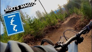
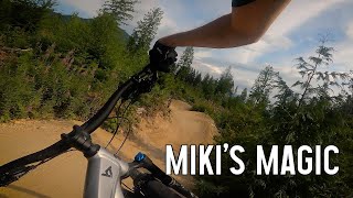
Mikayla Martin Memorial Trail.

Miki’s Magic, built in honour of the incredible Mikayla Martin, was a true community effort. We’re thankful we were able to contribute to this legacy.

Dream Wizards, SORCA Trail Crew, and a host of amazing volunteers brought this project to life. It was great to see so many of Mikayla’s lifelong friends come out and contribute to this trail, creating something that celebrates the fun, care and passion she brought to life.

Trail Supporters
Local Trail Association
Traditionally Indigenous Territory

Recent Activity on Trail

Past Week
  • 39 rides
  • 14 miles average
6 Months
  • 572 rides
  • 13 miles avg distance
All
  • 4,835 rides
  • Last: Jun 22, 2026
c1c2c3c4
January
February
March
April
May
June
July
August
September
October
November
December
Status:
on Jun 20, 2026
Dry
Avg: 4.76 (62 votes)
Your vote: 0

view (31,601)
close
3D
Trail Conditions
  • Unknown
  • Snow Groomed
  • Snow Packed
  • Snow Covered
  • Snow Cover Partial
  • Freeze/thaw Cycle
  • Icy
  • Prevalent Mud
  • Wet
  • Variable
  • Ideal
  • Dry
  • Very Dry
Trail Flow (Ridden Direction)
Trailforks scans users ridelogs to determine the most popular direction each trail is ridden. A good flowing trail network will have most trails flowing in a single direction according to their intension.
The colour categories are based on what percentage of riders are riding a trail in its intended direction.
  • > 96%
  • > 90%
  • > 80%
  • > 70%
  • > 50%
  • < 50%
  • bi-directional trail
  • no data
Trail Last Ridden
Trailforks scans ridelogs to determine the last time a trail was ridden.
  • < 2 days
  • < 1 week
  • < 2 weeks
  • < 1 month
  • < 6 months
  • > 6 months
Trail Ridden Direction
The intended direction a trail should be ridden.
  • Downhill Only
  • Downhill Primary
  • Both Directions
  • Uphill Primary
  • Uphill Only
  • One Direction
Contribute Details
Colors indicate trail is missing specified detail.
  • Description
  • Photos
  • Description & Photos
  • Videos
Trail Popularity ?
Trailforks scans ridelogs to determine which trails are ridden the most in the last 9 months. Trails are compared with nearby trails in the same city region with a possible 25 colour shades. Think of this as a heatmap, more rides = more kinetic energy = warmer colors.
  • most popular
  • popular
  • less popular
  • not popular
ATV/ORV/OHV Filter
Max Vehicle Width
inches
US Cell Coverage
Legend
cell carrier legend

Radar Time
Activity Recordings
Trailforks uses anonymized public activity data. ?
Activity Recordings
Trailforks uses anonymized public activity data. ?
Personal Heatmap
Activity Types
all / none
Options
2
Date range month
Winter Trails
Warning A routing network for winter maps does not exist. Selecting trails using the winter trails layer has been disabled.
Missing Trails
Most Popular
Least Popular
Trails are colored based on popularity. The more popular a trail is, the more red. Less popular trails trend towards green.
Jump Magnitude Heatmap
Heatmap of where riders jump on trails. Zoom in to see individual jumps, click circles to view jump details.
BC Backroad Status

Service Road Atlas is a free to use, community-driven service for viewing and creating reports on the numerous back-country service roads around B.C. and Alberta.

map legend
Slope Aspect
Direction the slope faces
Flat N NE E SE S SW W NW
Trails Deemphasized
Trails are shown in grey.
disable
Only show trails with no bike usage.
Enable
Suggested Layers
Based on selected activity type

    Save the current map location and zoom level as your default home location whenever this page is loaded.

    Save
        Directions to miki-s-magic trailhead (49.790650, -123.094700)

        Photos

        65 more »
        105 |
        Jun 14, 2024 @ 10:25pm
        Jun 14, 2024
        85 |
        Jun 14, 2024 @ 10:20pm
        Jun 14, 2024
        77 |
        Jun 14, 2024 @ 10:20pm
        Jun 14, 2024
        79 |
        Jun 14, 2024 @ 10:18pm
        Jun 14, 2024

        Videos

        25 more »
        youtuber MIKI'S MAGIC | Blue trail | Squamish - Alice Lake
        0:40 | 122 | Dec 16, 2023 , Squamish
        youtuber Miki's Magic - Squamish MTB
        0:47 | 640 | Jul 8, 2021 , Squamish
        youtuber Miki's Magic | The Best BEGINNER Jump Trail in...
        0:49 | 635 | Aug 18, 2023 , Squamish
        youtuber New Miki's Magic in Squamish, BC
        4:15 | 527 | Jun 19, 2023 , Squamish

        Routes with this trail

        5.0 12 miles 2,018 ft 9
        Second year of the Spring Tune up Charity SORCA event
        5.0 9 miles 1,346 ft 8
        Intro to Squamish - Alice Lake
        17 miles 2,644 ft 17 Loop
        Canada’s ultimate enduro throwdown. Every spring, riders roll into Squamish to rip some of the best...

        10 Reviews & Comments


        We hope you've been enjoying Trailforks!

        Create a FREE account to view trail comments and much more.

        Frequently Asked Questions About Miki's Magic

        Where is Miki's Magic located?
        Miki's Magic is located in Alice Lake & Highlands, Squamish, British Columbia, Canada. It is part of the Alice Lake & Highlands trail network. The trailhead is located at coordinates 49.79065, -123.0947.
        How hard is Miki's Magic?
        Miki's Magic is rated as Blue difficulty. The physical rating is Moderate. The average grade is 5.4%.
        What is the elevation gain for Miki's Magic?
        The trail has 41 m of elevation descent. The elevation ranges from 378 m to 418 m.
        Is Miki's Magic a point to point trail?
        Yes, Miki's Magic is a point to point trail. The direction is Downhill Only. The trail type is machine groomed.

        Hit the Trail

        Open in App

        Get this trail on your phone instantly.
        open trail in app

        Download Trail

        Save to wishlist, Garmin & download.
        save the trail

        Find Related Routes

        Find routes and users activities that include this trail.
        find routes for this trail

        You must enter a description before submitting.