more stats
1.2 miles
Distance
106 ft
Climb
-5 ft
Descent
01:45:14
Avg time
101 ft
Altitude change
4,923 ft
Altitude min
5,024 ft
Altitude max
4,923 ft
Altitude start
5,023 ft
Altitude end
1.6%
Grade
-1.8%
Grade max
9%
Grade min
3,819 ft
Distance climb
676 ft
Distance down
1,739 ft
Distance flat
01:45:14
Avg time

Minnewanka Details

  • Activities
    • Mountain Bike
    • Winter Fat Bike
    • Hike
    • Trail Running
  • Riding Area
    Banff National Park
    Banff, Alberta
  • Difficulty Rating
  • Voted Difficulty
    Blue (2 votes)
  • Local Popularity
    65 in Mountain Biking [+]
    • 65 in Trail Running
    • 75 in Hiking
  • Global Ranking
    #37672 in Mountain Biking [+]
    • #48551 in Trail Running
    • #9866 in Hiking
  • Trail Type
    Singletrack
  • Bike Type
    AM, XC, Fat
  • Climb Difficulty
    Green
  • Physical Rating
    Moderate
  • Season
    Sept 15 - July 10
  • Dogs Allowed
    Yes
  • eBike Allowed
  • Land Owner

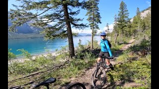
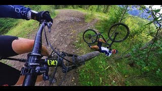
Out and back trail along Minnewanka lake. Usually opens up early in the season for riding. The hardest climb is near the beginning, the rest is up and down along the lake shore. The riding is not super-technical, but it is singletrack with roots and rocks. It's also fun in the winter, where you can ride on the frozen lake [studded tires recommended - make sure it's frozen - ride at your own risk].

Note that Minnewanka is one of the most popular trails in Banff. There can be HUGE crowds of hikers on weekends. Start and finish early on the weekends, or ride on weekdays to avoid the masses. If you are riding the trail, don't stop for a rest on the narrow exposed sections - keep moving until you can find a spot to stop where others can pass you.

Seasonal Restriction for bicycle is in effect from July 10 - September 15.

Access Info

Public Transit - Route 6

From the Minnewanka parking lot, the trail starts at the northeast end past the picnic tables.

Disclaimer

Seasonal Closure to bikes is from July 10 - September 15

Recent Activity on Trail

Past Week
  • 2 rides
  • 17 miles average
6 Months
  • 4 rides
  • 13 miles avg distance
All
  • 180 rides
  • Last: Jun 17, 2026
c1c2c3c4
January
February
March
April
May
June
July
August
September
October
November
December
update trails status or condition

Minnewanka Trail Reports

statusdatedescription
Jun 15, 2026 @ 8:41am (America/Edmonton)
Jun 15, 2026
Closed until further notice.
Feb 1, 2026 @ 12:39pm (America/Edmonton)
Feb 1, 2026
Hard pack snow/ice/dirt with annoying frozen footprints all the way to LM8, then rode great shoreline ice the rest of the way to the Warden’s...
Nov 9, 2025 @ 4:35pm (America/Edmonton)
Nov 9, 2025
tree down can ride ova
Nov 9, 2025 @ 4:12pm (America/Edmonton)
Nov 9, 2025
2 trees down
Nov 9, 2025 @ 3:58pm (America/Edmonton)
Nov 9, 2025
tree down
more »
Status:
on Jun 15, 2026
Avg: 4.09 (16 votes)
Your vote: 0

view (1,578)
close
3D
Trail Conditions
  • Unknown
  • Snow Groomed
  • Snow Packed
  • Snow Covered
  • Snow Cover Partial
  • Freeze/thaw Cycle
  • Icy
  • Prevalent Mud
  • Wet
  • Variable
  • Ideal
  • Dry
  • Very Dry
Trail Flow (Ridden Direction)
Trailforks scans users ridelogs to determine the most popular direction each trail is ridden. A good flowing trail network will have most trails flowing in a single direction according to their intension.
The colour categories are based on what percentage of riders are riding a trail in its intended direction.
  • > 96%
  • > 90%
  • > 80%
  • > 70%
  • > 50%
  • < 50%
  • bi-directional trail
  • no data
Trail Last Ridden
Trailforks scans ridelogs to determine the last time a trail was ridden.
  • < 2 days
  • < 1 week
  • < 2 weeks
  • < 1 month
  • < 6 months
  • > 6 months
Trail Ridden Direction
The intended direction a trail should be ridden.
  • Downhill Only
  • Downhill Primary
  • Both Directions
  • Uphill Primary
  • Uphill Only
  • One Direction
Contribute Details
Colors indicate trail is missing specified detail.
  • Description
  • Photos
  • Description & Photos
  • Videos
Trail Popularity ?
Trailforks scans ridelogs to determine which trails are ridden the most in the last 9 months. Trails are compared with nearby trails in the same city region with a possible 25 colour shades. Think of this as a heatmap, more rides = more kinetic energy = warmer colors.
  • most popular
  • popular
  • less popular
  • not popular
ATV/ORV/OHV Filter
Max Vehicle Width
inches
US Cell Coverage
Legend
cell carrier legend

Radar Time
Activity Recordings
Trailforks uses anonymized public activity data. ?
Activity Recordings
Trailforks uses anonymized public activity data. ?
Personal Heatmap
Activity Types
all / none
Options
2
Date range month
Winter Trails
Warning A routing network for winter maps does not exist. Selecting trails using the winter trails layer has been disabled.
Missing Trails
Most Popular
Least Popular
Trails are colored based on popularity. The more popular a trail is, the more red. Less popular trails trend towards green.
Jump Magnitude Heatmap
Heatmap of where riders jump on trails. Zoom in to see individual jumps, click circles to view jump details.
BC Backroad Status

Service Road Atlas is a free to use, community-driven service for viewing and creating reports on the numerous back-country service roads around B.C. and Alberta.

map legend
Slope Aspect
Direction the slope faces
Flat N NE E SE S SW W NW
Trails Deemphasized
Trails are shown in grey.
disable
Only show trails with no bike usage.
Enable
Suggested Layers
Based on selected activity type

    Save the current map location and zoom level as your default home location whenever this page is loaded.

    Save
        Directions to minnewanka trailhead (51.247730, -115.500600)

        Photos

        103 more »
        670 |
        Oct 27, 2017 @ 12:30pm
        Oct 27, 2017
        634 |
        Oct 14, 2014 @ 1:34pm
        Oct 14, 2014
        933 |
        Oct 27, 2012 @ 1:05am
        Oct 27, 2012
        753 |
        Aug 20, 2013 @ 8:25am
        Aug 20, 2013

        Videos

        6 more »
        The BEST View Ever! - Lake Minnewanka (In...
        50:42 | 68 | Sep 1, 2025 , Banff
        Places 2 MTB:  Lake Minnewanka Trail
        14:21 | 349 | Mar 19, 2023 , Banff
        Minnawanka Bankhead Mountain Bike
        6:38 | 969 | Sep 19, 2019 , Banff
        Motorboat Cruisin’
        0:00 | 19 | Aug 20, 2022 , Banff

        Routes with this trail

        1.0 162 miles 19,314 ft 106 Loop
        Think you've got what it takes to tackle this monster ride? This is the ultimate link-up of single track...

        15 Reviews & Comments


        We hope you've been enjoying Trailforks!

        Create a FREE account to view trail comments and much more.

        • By dannyTF Pro & contributors
        • #5946 - 35,557 views

        Frequently Asked Questions About Minnewanka

        Where is Minnewanka located?
        Minnewanka is located in Banff National Park, Banff, Alberta, Canada. It is part of the Banff National Park trail network. The trailhead is located at coordinates 51.24773, -115.5006.
        How hard is Minnewanka?
        Minnewanka is rated as Blue difficulty. The physical rating is Moderate. The average grade is 0.1%. The climb difficulty is rated Green.
        What is the elevation gain for Minnewanka?
        Minnewanka has 142 m of elevation gain. The trail has 121 m of elevation descent. The elevation ranges from 1,500 m to 1,568 m.
        How long is Minnewanka?
        Minnewanka is 15.0 km long. The trail type is singletrack.

        Hit the Trail

        Open in App

        Get this trail on your phone instantly.
        open trail in app

        Download Trail

        Save to wishlist, Garmin & download.
        save the trail

        Find Related Routes

        Find routes and users activities that include this trail.
        find routes for this trail

        You must enter a description before submitting.