more stats
4,386 ft
Distance
19 ft
Climb
-983 ft
Descent
00:09:23
Avg time
-964 ft
Altitude change
3,763 ft
Altitude min
4,728 ft
Altitude max
4,727 ft
Altitude start
3,763 ft
Altitude end
-22%
Grade
-55.1%
Grade max
14.4%
Grade min
207 ft
Distance climb
3,724 ft
Distance down
456 ft
Distance flat
00:09:23
Avg time

Miss Fire Details

  • Activities
    • Mountain Bike
  • Riding Area
    Whistler Mountain Bike Park
    Whistler, British Columbia
  • Difficulty Rating
  • Voted Difficulty
    Black Diamond (7 votes)
  • Local Popularity
    35 in Mountain Biking
  • Global Ranking
    #34641 in Mountain Biking
  • Trail Type
    Singletrack
  • Bike Type
    DH, AM
  • Direction
    Downhill Only
    Popular Direction Shown
  • eBike Allowed
  • TTFs on Trail
    Bridge

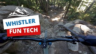
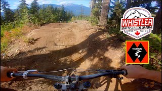
Some fine technical that winds through the depths of the upper Creekside forest. Connect Miss Fire with Top of the World, Delayed Fuse and BC's for the ultimate technical Peak to Creek ride.

Access Info

Access from Top of the World or from Garbanzo across the Hwy 86 bridge - trail begins off of Midgard.

Bike Park

Recent Activity on Trail

Past Week
  • 7 rides
  • 18 miles average
6 Months
  • 7 rides
  • 18 miles avg distance
All
  • 736 rides
  • Last: Jun 23, 2026
c1c2c3c4
January
February
March
April
May
June
July
August
September
October
November
December
update trails status or condition

Miss Fire Trail Reports

statusdatedescription
Oct 18, 2025 @ 11:49pm (America/Vancouver)
Oct 18, 2025
Closed for the season, see you in 2026
Sep 11, 2025 @ 10:09am (America/Vancouver)
Sep 11, 2025
Amazing shape!
Aug 31, 2025 @ 3:14pm
Aug 31, 2025
Construction
Aug 25, 2025 @ 3:48pm
Aug 25, 2025
Open, Mid guard is still closed for trail work.
Aug 18, 2025 @ 6:03pm
Aug 18, 2025
Trail’s currently closed unfortunately.
more »
Status:
on Oct 18, 2025
Avg: 4.79 (41 votes)
Your vote: 0

view (4,295)
close
3D
Trail Conditions
  • Unknown
  • Snow Groomed
  • Snow Packed
  • Snow Covered
  • Snow Cover Partial
  • Freeze/thaw Cycle
  • Icy
  • Prevalent Mud
  • Wet
  • Variable
  • Ideal
  • Dry
  • Very Dry
Trail Flow (Ridden Direction)
Trailforks scans users ridelogs to determine the most popular direction each trail is ridden. A good flowing trail network will have most trails flowing in a single direction according to their intension.
The colour categories are based on what percentage of riders are riding a trail in its intended direction.
  • > 96%
  • > 90%
  • > 80%
  • > 70%
  • > 50%
  • < 50%
  • bi-directional trail
  • no data
Trail Last Ridden
Trailforks scans ridelogs to determine the last time a trail was ridden.
  • < 2 days
  • < 1 week
  • < 2 weeks
  • < 1 month
  • < 6 months
  • > 6 months
Trail Ridden Direction
The intended direction a trail should be ridden.
  • Downhill Only
  • Downhill Primary
  • Both Directions
  • Uphill Primary
  • Uphill Only
  • One Direction
Contribute Details
Colors indicate trail is missing specified detail.
  • Description
  • Photos
  • Description & Photos
  • Videos
Trail Popularity ?
Trailforks scans ridelogs to determine which trails are ridden the most in the last 9 months. Trails are compared with nearby trails in the same city region with a possible 25 colour shades. Think of this as a heatmap, more rides = more kinetic energy = warmer colors.
  • most popular
  • popular
  • less popular
  • not popular
ATV/ORV/OHV Filter
Max Vehicle Width
inches
US Cell Coverage
Legend
cell carrier legend

Radar Time
Activity Recordings
Trailforks uses anonymized public activity data. ?
Activity Recordings
Trailforks uses anonymized public activity data. ?
Personal Heatmap
Activity Types
all / none
Options
2
Date range month
Winter Trails
Warning A routing network for winter maps does not exist. Selecting trails using the winter trails layer has been disabled.
Missing Trails
Most Popular
Least Popular
Trails are colored based on popularity. The more popular a trail is, the more red. Less popular trails trend towards green.
Jump Magnitude Heatmap
Heatmap of where riders jump on trails. Zoom in to see individual jumps, click circles to view jump details.
BC Backroad Status

Service Road Atlas is a free to use, community-driven service for viewing and creating reports on the numerous back-country service roads around B.C. and Alberta.

map legend
Slope Aspect
Direction the slope faces
Flat N NE E SE S SW W NW
Trails Deemphasized
Trails are shown in grey.
disable
Only show trails with no bike usage.
Enable
Suggested Layers
Based on selected activity type

    Save the current map location and zoom level as your default home location whenever this page is loaded.

    Save
        Directions to miss-fire trailhead (50.076680, -122.962080)

        Photos

        21 more »
        42 |
        Sep 11, 2025 @ 5:32pm
        Sep 11, 2025
        92 |
        Jul 17, 2024 @ 3:50pm
        Jul 17, 2024
        91 |
        Jul 17, 2024 @ 3:50pm
        Jul 17, 2024
        90 |
        Jul 17, 2024 @ 3:50pm
        Jul 17, 2024

        Videos

        17 more »
        youtuber BRITISH COLUMBIA Healthy Mix of Flow, Tech...
        11:22 | 256 | Dec 1, 2023 , Whistler
        CREEKSIDE CARDIO- Missfire, Delayed Fuse,...
        16:30 | 179 | Nov 3, 2024 , Whistler
        youtuber My favourite trails in Whistler Bike Park
        16:53 | 200 | Jul 15, 2024 , Whistler
        youtuber Most INSANE Moments of 2023! (Pt. 4) -...
        8:19 | 182 | Jan 7, 2024 , Whistler

        Trail Lists

        Routes with this trail

        4.0 24 miles 10,095 ft 29
        The course route for the 2023 Canadian Open Enduro 9:00 am – 3:30 pm 8:30 am – 4:30 pm 5:30pm-6:30pm...
        5.0 4 miles 223 ft 3
        Creekside Pull from Garbo
        7 miles 187 ft 4
        A ride that utilizes the entire Top of the World trail instead of breaking off at .

        18 Reviews & Comments


        We hope you've been enjoying Trailforks!

        Create a FREE account to view trail comments and much more.

        • By spokeydokeTF Pro WBP & contributors
        • #192963 - 7,321 views

        Frequently Asked Questions About Miss Fire

        Where is Miss Fire located?
        Miss Fire is located in Whistler Mountain Bike Park, Whistler, British Columbia, Canada. It is part of the Whistler Mountain Bike Park trail network. The trailhead is located at coordinates 50.07668, -122.96208.
        How hard is Miss Fire?
        Miss Fire is rated as Double Black Diamond difficulty. The average grade is 22%.
        What is the elevation gain for Miss Fire?
        Miss Fire has 19 ft of elevation gain. The trail has 983 ft of elevation descent. The elevation ranges from 3,763 ft to 4,728 ft.
        Is Miss Fire a point to point trail?
        Yes, Miss Fire is a point to point trail. The direction is Downhill Only. The trail type is singletrack.

        Hit the Trail

        Open in App

        Get this trail on your phone instantly.
        open trail in app

        Download Trail

        Save to wishlist, Garmin & download.
        save the trail

        Find Related Routes

        Find routes and users activities that include this trail.
        find routes for this trail

        You must enter a description before submitting.