more stats
1,575 ft
Distance
38 ft
Climb
-173 ft
Descent
00:07:23
Avg time
-135 ft
Altitude change
1,387 ft
Altitude min
1,560 ft
Altitude max
1,522 ft
Altitude start
1,388 ft
Altitude end
-8.6%
Grade
-34.4%
Grade max
26.8%
Grade min
400 ft
Distance climb
1,175 ft
Distance down
00:07:23
Avg time

The Mistress Details

  • Activities
    • Dirtbike/Moto
    • Mountain Bike
    • Hike
    • Trail Running
    • Observed Trials
  • Riding Area
    Eagle Mountain
    Coquitlam, British Columbia
  • Difficulty Rating
  • Local Popularity
    55 in Mountain Biking [+]
    • 55 in Trail Running
    • 55 in Hiking
    • 65 in Dirtbiking
    • 5 in Observed Trials
  • Global Ranking
    #98186 in Mountain Biking [+]
    • #98409 in Trail Running
    • #102129 in Hiking
    • #2072 in Dirtbiking
    • #191 in Observed Trials
  • Trail Type
    Singletrack
  • Dogs Allowed
    Yes

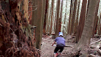
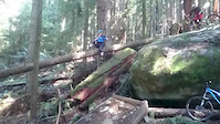
This trail is no longer recognized as a mountain bike trail. Most of the historic technical features, including the long log ride, have now been incorporated into the new trail Marvin.

This trail is unsanctioned.

Recent Activity on Trail

Past Week
  • 1 rides
  • 11 miles average
6 Months
  • 10 rides
  • 9 miles avg distance
All
  • 128 rides
  • Last: Jun 17, 2026
c1c2c3c4
January
February
March
April
May
June
July
August
September
October
November
December
update trails status or condition

The Mistress Trail Reports

statusdatedescription
Jun 17, 2026 @ 3:17pm (America/Vancouver)
Jun 17, 2026
Oct 25, 2024 @ 5:34pm
Oct 25, 2024
some water channeling besides the Marvin log ride, and some more below the tombstone drop. other than that, the trail looks like it did before...
Oct 25, 2024 @ 12:09pm
Oct 25, 2024
reporter "Mistress has significant erosion once if intersects Marvin, checked it yesterday" per Brad's report.
Apr 10, 2024 @ 4:17pm
Apr 10, 2024
Oct 5, 2023 @ 7:47pm
Oct 5, 2023
reporter
more »
Status:
on Jun 17, 2026
Dry
Avg: 3.9 (15 votes)
Your vote: 0

view (1,036)
close
3D
Trail Conditions
  • Unknown
  • Snow Groomed
  • Snow Packed
  • Snow Covered
  • Snow Cover Partial
  • Freeze/thaw Cycle
  • Icy
  • Prevalent Mud
  • Wet
  • Variable
  • Ideal
  • Dry
  • Very Dry
Trail Flow (Ridden Direction)
Trailforks scans users ridelogs to determine the most popular direction each trail is ridden. A good flowing trail network will have most trails flowing in a single direction according to their intension.
The colour categories are based on what percentage of riders are riding a trail in its intended direction.
  • > 96%
  • > 90%
  • > 80%
  • > 70%
  • > 50%
  • < 50%
  • bi-directional trail
  • no data
Trail Last Ridden
Trailforks scans ridelogs to determine the last time a trail was ridden.
  • < 2 days
  • < 1 week
  • < 2 weeks
  • < 1 month
  • < 6 months
  • > 6 months
Trail Ridden Direction
The intended direction a trail should be ridden.
  • Downhill Only
  • Downhill Primary
  • Both Directions
  • Uphill Primary
  • Uphill Only
  • One Direction
Contribute Details
Colors indicate trail is missing specified detail.
  • Description
  • Photos
  • Description & Photos
  • Videos
Trail Popularity ?
Trailforks scans ridelogs to determine which trails are ridden the most in the last 9 months. Trails are compared with nearby trails in the same city region with a possible 25 colour shades. Think of this as a heatmap, more rides = more kinetic energy = warmer colors.
  • most popular
  • popular
  • less popular
  • not popular
ATV/ORV/OHV Filter
Max Vehicle Width
inches
US Cell Coverage
Legend
cell carrier legend

Radar Time
Activity Recordings
Trailforks uses anonymized public activity data. ?
Activity Recordings
Trailforks uses anonymized public activity data. ?
Personal Heatmap
Activity Types
all / none
Options
2
Date range month
Winter Trails
Warning A routing network for winter maps does not exist. Selecting trails using the winter trails layer has been disabled.
Missing Trails
Most Popular
Least Popular
Trails are colored based on popularity. The more popular a trail is, the more red. Less popular trails trend towards green.
Jump Magnitude Heatmap
Heatmap of where riders jump on trails. Zoom in to see individual jumps, click circles to view jump details.
BC Backroad Status

Service Road Atlas is a free to use, community-driven service for viewing and creating reports on the numerous back-country service roads around B.C. and Alberta.

map legend
Slope Aspect
Direction the slope faces
Flat N NE E SE S SW W NW
Trails Deemphasized
Trails are shown in grey.
disable
Only show trails with no bike usage.
Enable
Suggested Layers
Based on selected activity type

    Save the current map location and zoom level as your default home location whenever this page is loaded.

    Save
        Directions to mistress trailhead (49.319400, -122.832730)

        Photos

        37 more »
        639 |
        Apr 1, 2014 @ 11:47am
        Apr 1, 2014
        597 |
        Apr 1, 2014 @ 11:47am
        Apr 1, 2014
        235 |
        Dec 26, 2019 @ 10:42am
        Dec 26, 2019
        206 |
        Dec 26, 2019 @ 10:42am
        Dec 26, 2019

        Videos

        2 more »
        The Mistress
        0:42 | 1824 | Apr 17, 2016 , Coquitlam
        Rock Drop
        0:06 | 1213 | Apr 2, 2016 , Coquitlam

        Routes with this trail

        10 miles 3,012 ft 56 Loop
        A route that starts from the aspenwood parking lot and takes you through the majority of the black trails...

        3 Reviews & Comments


        We hope you've been enjoying Trailforks!

        Create a FREE account to view trail comments and much more.

        • #819 - 6,570 views

        Frequently Asked Questions About The Mistress

        Where is The Mistress located?
        The Mistress is located in Eagle Mountain, Coquitlam, British Columbia, Canada. It is part of the Eagle Mountain trail network. The trailhead is located at coordinates 49.3194, -122.83273.
        How hard is The Mistress?
        The Mistress is rated as Black Diamond difficulty. The average grade is 7.1%.
        What is the elevation gain for The Mistress?
        The Mistress has 12 m of elevation gain. The trail has 46 m of elevation descent. The elevation ranges from 430 m to 476 m.
        Is The Mistress a point to point trail?
        Yes, The Mistress is a point to point trail. The direction is Downhill Only. The trail type is singletrack.

        Hit the Trail

        Open in App

        Get this trail on your phone instantly.
        open trail in app

        Download Trail

        Save to wishlist, Garmin & download.
        save the trail

        Find Related Routes

        Find routes and users activities that include this trail.
        find routes for this trail

        You must enter a description before submitting.