more stats
1.1 miles
Distance
-441 ft
Descent
00:05:13
Avg time
-443 ft
Altitude change
3,499 ft
Altitude min
3,942 ft
Altitude max
3,942 ft
Altitude start
3,501 ft
Altitude end
-7.7%
Grade
-48.6%
Grade max
0.2%
Grade min
1 mile
Distance down
279 ft
Distance flat
00:05:13
Avg time

Mo Z Details

  • Activities
    • Mountain Bike
    • Hike
    • Trail Running
  • Riding Area
    Pattee Canyon
    Missoula, Montana
  • Difficulty Rating
  • Local Popularity
    100 in Mountain Biking [+]
    • 100 in Trail Running
    • 100 in Hiking
  • Global Ranking
    #44045 in Mountain Biking [+]
    • #1545 in Trail Running
    • #3475 in Hiking
  • Trail Type
    Singletrack
  • Bike Type
    XC
  • Direction
    Downhill Primary
    Popular Direction Shown
  • Physical Rating
    Moderate
  • Dogs Allowed
    Yes
  • Land Owner
    USFS

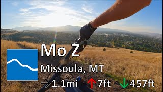
This trail focuses on FLOW. There are a few switchbacks but for the most part they are bermed and wide enough to keep your speed. This is the primary route to use to get to the upper Pattee Creek trails higher up in the canyon.

Local Trail Association
Traditionally Indigenous Territory

Recent Activity on Trail

Past Week
  • 3 rides
  • 29 miles average
6 Months
  • 103 rides
  • 15 miles avg distance
All
  • 1,051 rides
  • Last: Jun 27, 2026
c1c2c3c4
January
February
March
April
May
June
July
August
September
October
November
December
update trails status or condition

Mo Z Trail Reports

statusdatedescription
May 2, 2026 @ 1:26pm (America/Denver)
May 2, 2026
Mar 27, 2026 @ 2:22pm (America/Denver)
Mar 27, 2026
About as good as Moz gets! Dry in the center with weeping moisture on edges and in berms. (No mud). Dare I say hero dirt?
Mar 1, 2026 @ 9:21am (America/Denver)
Mar 1, 2026
Rideable but probably not good trail stewardship due to moisture. Minor erosion (trail braiding, small ruts developing)
Feb 7, 2026 @ 11:53am (America/Denver)
Feb 7, 2026
A bit wet in some to the switchback corners.
Dec 14, 2025 @ 2:39pm (America/Denver)
Dec 14, 2025
more »
Status:
on May 2, 2026
Ideal
Avg: 3.89 (13 votes)
Your vote: 0

view (9,702)
close
3D
Trail Conditions
  • Unknown
  • Snow Groomed
  • Snow Packed
  • Snow Covered
  • Snow Cover Partial
  • Freeze/thaw Cycle
  • Icy
  • Prevalent Mud
  • Wet
  • Variable
  • Ideal
  • Dry
  • Very Dry
Trail Flow (Ridden Direction)
Trailforks scans users ridelogs to determine the most popular direction each trail is ridden. A good flowing trail network will have most trails flowing in a single direction according to their intension.
The colour categories are based on what percentage of riders are riding a trail in its intended direction.
  • > 96%
  • > 90%
  • > 80%
  • > 70%
  • > 50%
  • < 50%
  • bi-directional trail
  • no data
Trail Last Ridden
Trailforks scans ridelogs to determine the last time a trail was ridden.
  • < 2 days
  • < 1 week
  • < 2 weeks
  • < 1 month
  • < 6 months
  • > 6 months
Trail Ridden Direction
The intended direction a trail should be ridden.
  • Downhill Only
  • Downhill Primary
  • Both Directions
  • Uphill Primary
  • Uphill Only
  • One Direction
Contribute Details
Colors indicate trail is missing specified detail.
  • Description
  • Photos
  • Description & Photos
  • Videos
Trail Popularity ?
Trailforks scans ridelogs to determine which trails are ridden the most in the last 9 months. Trails are compared with nearby trails in the same city region with a possible 25 colour shades. Think of this as a heatmap, more rides = more kinetic energy = warmer colors.
  • most popular
  • popular
  • less popular
  • not popular
ATV/ORV/OHV Filter
Max Vehicle Width
inches
US Cell Coverage
Legend
cell carrier legend

Radar Time
Activity Recordings
Trailforks uses anonymized public activity data. ?
Activity Recordings
Trailforks uses anonymized public activity data. ?
Personal Heatmap
Activity Types
all / none
Options
2
Date range month
Winter Trails
Warning A routing network for winter maps does not exist. Selecting trails using the winter trails layer has been disabled.
Missing Trails
Most Popular
Least Popular
Trails are colored based on popularity. The more popular a trail is, the more red. Less popular trails trend towards green.
Jump Magnitude Heatmap
Heatmap of where riders jump on trails. Zoom in to see individual jumps, click circles to view jump details.
BC Backroad Status

Service Road Atlas is a free to use, community-driven service for viewing and creating reports on the numerous back-country service roads around B.C. and Alberta.

map legend
Slope Aspect
Direction the slope faces
Flat N NE E SE S SW W NW
Trails Deemphasized
Trails are shown in grey.
disable
Only show trails with no bike usage.
Enable
Suggested Layers
Based on selected activity type

    Save the current map location and zoom level as your default home location whenever this page is loaded.

    Save
        Directions to mo-z trailhead (46.834480, -113.980130)

        Photos

        8 more »
        133 |
        Jun 11, 2023 @ 3:09pm
        Jun 11, 2023
        125 |
        Jun 11, 2023 @ 3:08pm
        Jun 11, 2023
        96 |
        Jun 11, 2023 @ 3:08pm
        Jun 11, 2023
        245 |
        Oct 13, 2019 @ 12:45am
        Oct 13, 2019

        Videos

        2 more »
        youtuber Mo Z - Pattee Canyon - Missoula, MT
        5:04 | 289 | Oct 12, 2022 , Missoula
        Mountain Bike Ride on Mt. Sentinel In Missoula...
        511 | May 19, 2019 , Missoula

        Routes with this trail

        3.8 16 miles 1,571 ft 8 Loop
        The classic Missoula ride around Mount Sentinel. The route is typically ridden clockwise to end on the MoZ...
        3.0 9 miles 1,646 ft 15 Out & Back
        This is a good intermediate intro ride for the lower Pattee Canyon. It's not super long on mileage, but...
        11 miles 1,977 ft 7 Loop
        This route provides a way to link the Barmeyer and Moz trails into a loop with two good climbs and fun...

        3 Reviews & Comments


        We hope you've been enjoying Trailforks!

        Create a FREE account to view trail comments and much more.

        • By DbpooleTF Pro & contributors
        • #31483 - 7,708 views

        Frequently Asked Questions About Mo Z

        Where is Mo Z located?
        Mo Z is located in Pattee Canyon, Missoula, Montana, United States. It is part of the Pattee Canyon trail network. The trailhead is located at coordinates 46.83448, -113.98013.
        How hard is Mo Z?
        Mo Z is rated as Green difficulty. The physical rating is Moderate. The average grade is 7.7%.
        What is the elevation gain for Mo Z?
        The trail has 441 ft of elevation descent. The elevation ranges from 3,499 ft to 3,942 ft.
        Is Mo Z a point to point trail?
        Mo Z is not a point to point trail. The direction is Downhill Primary. The trail type is singletrack.

        Hit the Trail

        Open in App

        Get this trail on your phone instantly.
        open trail in app

        Download Trail

        Save to wishlist, Garmin & download.
        save the trail

        Find Related Routes

        Find routes and users activities that include this trail.
        find routes for this trail

        You must enter a description before submitting.