more stats
10.2 miles
Distance
1,005 ft
Climb
-1,556 ft
Descent
01:42:22
Avg time
-552 ft
Altitude change
10,842 ft
Altitude min
11,965 ft
Altitude max
11,393 ft
Altitude start
10,843 ft
Altitude end
-1%
Grade
-52.1%
Grade max
37.1%
Grade min
4 miles
Distance climb
5 miles
Distance down
4,232 ft
Distance flat
01:42:22
Avg time

Trail Details

  • Activities
    • Mountain Bike
    • E-Bike
    • Horse
    • Hike
    • Trail Running
    • Dirtbike/Moto
  • Riding Area
    Salida
    , Colorado
  • Ref Number
    #9531
  • AKA
    CO18 - Marshall Pass to Monarch Pass Segment 15 - US-50 to Marshall Pass TH
  • Difficulty Rating
  • Voted Difficulty
    Blue (3 votes)
  • Local Popularity
    85 in Mountain Biking [+]
    • 95 in E-Biking
    • 45 in Trail Running
    • 70 in Hiking
    • 95 in Dirtbiking
    • 5 in Horseback
  • Global Ranking
    #11077 in Mountain Biking [+]
    • #8035 in E-Biking
    • #60971 in Trail Running
    • #1888 in Hiking
    • #866 in Horseback
  • Hiking SAC Scale
    T2 Mountain Hiking
  • Trail Type
    Singletrack
  • Bike Type
    AM, XC
  • Direction
    Downhill Primary
    Popular Direction Shown
  • Climb Difficulty
    Blue
  • Physical Rating
    Hard
  • Season
    July - Oct
  • Alpine Trail
    Yes
  • Dogs Allowed
    Yes
  • eBike Allowed
    Yes up to Class 1
  • Land Owner
    USFS

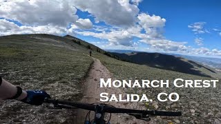
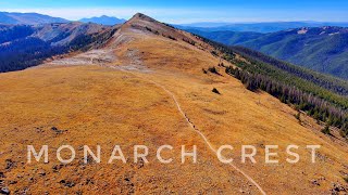
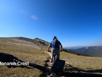
Monarch Crest is an epic High Country ride Super popular and for good reason. After you climb the dirt road and do a short climb, the views are amazing, and then more amazing as you navigate between small peaks. The views are 360 and you can see down multiple valleys. After you top out, the descent towards Green Creek is fast and furious. Lots of roots, and super fun.

Trail Supporters
Local Trail Association
Traditionally Indigenous Territory

Recent Activity on Trail

Past Week
  • 2 rides
  • 17 miles average
6 Months
  • 7 rides
  • 15 miles avg distance
All
  • 428 rides
  • Last: Jun 20, 2026
c1c2c3c4
January
February
March
April
May
June
July
August
September
October
November
December
update trails status or condition

CDT CT - Monarch... Trail Reports

statusdatedescription
Oct 9, 2024 @ 8:38am
Oct 9, 2024
Mostly dry, few puddles there and there
Aug 18, 2024 @ 11:48am
Aug 18, 2024
Nice and dry
Aug 18, 2024 @ 9:10am
Aug 18, 2024
Jun 24, 2024 @ 5:58pm
Jun 24, 2024
4 snow banks, just stay on top of the trail, don’t go around. 3 big trees down on downhill just before greens.
Sep 28, 2023 @ 3:24pm
Sep 28, 2023
more »
Status:
on Oct 9, 2024
Variable
Avg: 4.54 (31 votes)
Your vote: 0

view (2,988)
close
3D
Trail Conditions
  • Unknown
  • Snow Groomed
  • Snow Packed
  • Snow Covered
  • Snow Cover Partial
  • Freeze/thaw Cycle
  • Icy
  • Prevalent Mud
  • Wet
  • Variable
  • Ideal
  • Dry
  • Very Dry
Trail Flow (Ridden Direction)
Trailforks scans users ridelogs to determine the most popular direction each trail is ridden. A good flowing trail network will have most trails flowing in a single direction according to their intension.
The colour categories are based on what percentage of riders are riding a trail in its intended direction.
  • > 96%
  • > 90%
  • > 80%
  • > 70%
  • > 50%
  • < 50%
  • bi-directional trail
  • no data
Trail Last Ridden
Trailforks scans ridelogs to determine the last time a trail was ridden.
  • < 2 days
  • < 1 week
  • < 2 weeks
  • < 1 month
  • < 6 months
  • > 6 months
Trail Ridden Direction
The intended direction a trail should be ridden.
  • Downhill Only
  • Downhill Primary
  • Both Directions
  • Uphill Primary
  • Uphill Only
  • One Direction
Contribute Details
Colors indicate trail is missing specified detail.
  • Description
  • Photos
  • Description & Photos
  • Videos
Trail Popularity ?
Trailforks scans ridelogs to determine which trails are ridden the most in the last 9 months. Trails are compared with nearby trails in the same city region with a possible 25 colour shades. Think of this as a heatmap, more rides = more kinetic energy = warmer colors.
  • most popular
  • popular
  • less popular
  • not popular
ATV/ORV/OHV Filter
Max Vehicle Width
inches
US Cell Coverage
Legend
cell carrier legend

Radar Time
Activity Recordings
Trailforks uses anonymized public activity data. ?
Activity Recordings
Trailforks uses anonymized public activity data. ?
Personal Heatmap
Activity Types
all / none
Options
2
Date range month
Winter Trails
Warning A routing network for winter maps does not exist. Selecting trails using the winter trails layer has been disabled.
Missing Trails
Most Popular
Least Popular
Trails are colored based on popularity. The more popular a trail is, the more red. Less popular trails trend towards green.
Jump Magnitude Heatmap
Heatmap of where riders jump on trails. Zoom in to see individual jumps, click circles to view jump details.
BC Backroad Status

Service Road Atlas is a free to use, community-driven service for viewing and creating reports on the numerous back-country service roads around B.C. and Alberta.

map legend
Slope Aspect
Direction the slope faces
Flat N NE E SE S SW W NW
Trails Deemphasized
Trails are shown in grey.
disable
Only show trails with no bike usage.
Enable
Suggested Layers
Based on selected activity type

    Save the current map location and zoom level as your default home location whenever this page is loaded.

    Save
        Directions to cdt-ct-monarch-crest-trail trailhead (38.492780, -106.320240)

        Photos

        122 more »
        805 |
        Feb 28, 2012 @ 5:18pm
        Feb 28, 2012
        877 |
        May 28, 2013 @ 1:41pm
        May 28, 2013
        90 |
        Sep 26, 2025 @ 3:53pm
        Sep 26, 2025
        57 |
        Sep 26, 2025 @ 3:53pm
        Sep 26, 2025

        Videos

        20 more »
        youtuber This ride didn't go as planned...
        11:57 | 714 | Aug 23, 2018 , Salida
        Riding Monarch Crest Trail. Salida, CO
        6:51 | 506 | Jul 26, 2022 , Salida
        Add this Trail to your bucket list this Summer...
        17:51 | 487 | Apr 3, 2022 , Salida
        #MTB2K21 Day 6 - Monarch Starvation
        5:08 | 259 | Dec 19, 2021 , Salida

        Trail Lists

        Routes with this trail

        4.2 35 miles 2,660 ft 5 Point to Point
        The typical Monarch Crest route, starting from the ski area, traversing to Marshall Pass.
        5.0 45 miles 4,565 ft 6 Shuttled
        This route takes the standard Monarch Crest shuttle route but adds more to it by going all the way into...
        5.0 16 miles 802 ft 4 Point to Point
        Ride Monarch Crest Trail to Greens Creek

        1 Review & Comments


        We hope you've been enjoying Trailforks!

        Create a FREE account to view trail comments and much more.

        • By toddTF Pro Trailforks & contributors
        • #13954 - 21,694 views

        Frequently Asked Questions About CDT CT - Monarch Crest Trail

        Where is CDT CT - Monarch Crest Trail located?
        CDT CT - Monarch Crest Trail is located in Salida, Colorado, United States. It is part of the Salida trail network. The trailhead is located at coordinates 38.49278, -106.32024.
        How hard is CDT CT - Monarch Crest Trail?
        CDT CT - Monarch Crest Trail is rated as Blue difficulty. The physical rating is Hard. The average grade is 1%. The climb difficulty is rated Blue.
        What is the elevation gain for CDT CT - Monarch Crest Trail?
        CDT CT - Monarch Crest Trail has 1,005 ft of elevation gain. The trail has 1,556 ft of elevation descent. The elevation ranges from 10,842 ft to 11,965 ft.
        Is CDT CT - Monarch Crest Trail a point to point trail?
        CDT CT - Monarch Crest Trail is not a point to point trail. The direction is Downhill Primary. The trail type is singletrack.

        Hit the Trail

        Open in App

        Get this trail on your phone instantly.
        open trail in app

        Download Trail

        Save to wishlist, Garmin & download.
        save the trail

        Find Related Routes

        Find routes and users activities that include this trail.
        find routes for this trail

        You must enter a description before submitting.