more stats
3.1 miles
Distance
445 ft
Climb
-461 ft
Descent
00:57:25
Avg time
-16 ft
Altitude change
861 ft
Altitude min
1,126 ft
Altitude max
1,126 ft
Altitude start
1,109 ft
Altitude end
-0.1%
Grade
-31.6%
Grade max
34.3%
Grade min
1 mile
Distance climb
1 mile
Distance down
1,841 ft
Distance flat
00:57:25
Avg time

Montezuma Falls Upper Details

  • Activities
    • Mountain Bike
    • E-Bike
    • Gravel Bike
    • Adaptive Bike
    • Hike
    • Trail Running
  • Riding Area
  • Difficulty Rating
  • Local Popularity
    100 in Mountain Biking [+]
    • 100 in E-Biking
    • 100 in Trail Running
    • 85 in Hiking
  • Global Ranking
    #48638 in Mountain Biking [+]
    • #7087 in E-Biking
    • #4063 in Trail Running
    • #50989 in Hiking
  • Hiking SAC Scale
    T1 Hiking
  • Trail Type
    Gravel Path
  • Bike Type
    AM, XC, Adaptive MTB, Gravel
  • Direction
    Both Directions
  • Climb Difficulty
    Green
  • Physical Rating
    Easy
  • Trail Visibility
    Always easy to follow
  • Family Friendly
    Yes
  • Dogs Allowed
    Yes
  • eBike Allowed
    Yes up to Class 1

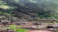
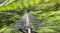
Montezuma Falls are Tasmania's tallest waterfall.This is a must-do trail if you are visiting the West Coast with the family. This shared trail meanders through cool temperate rainforst via an old mining tramway. The trail head and carpark are well maintained and there are toilet and picnic facilities. This is a beautiful easy introduction to 'adventure' mountain biking for the beginner and family orientated bike rides, with a gentle downhill gradient to reach the falls through some beautiful forests. Once at the falls, you will be impressed with the cascade falling from the sky like a silver ribbon down the mountain. For those up for a bit more adventure and with a lot more skills, you can carry on over the singel-file suspension bridge (not for the fainthearted) and tackle the blue Montezuma Falls Lower trail that carries on down to the Murchison Highway at Melba Flats via a 4WD road.

Access Info

Trail head well signposted from the Murchison Highway (A10) on the southwest side of Rosebery. Follow the sealed/gravel road uphill about 8km to the carpark and trail head.

Traditionally Indigenous Territory

Recent Activity on Trail

Past Week
  • 0 rides
  •  
6 Months
  • 3 rides
  • 12.0 km avg distance
All
  • 21 rides
  • Last: Jun 8, 2026
c1c2c3c4
January
February
March
April
May
June
July
August
September
October
November
December
update trails status or condition

Montezuma Falls... Trail Reports

statusdatedescription
Oct 6, 2025 @ 8:37pm (Australia/Hobart)
Oct 6, 2025
Trail was very wet, but it’s been raining for weeks so not surprising. Two issues: Approx 3km from start there has been a (recent?) landslide....
Feb 1, 2023 @ 10:57pm
Feb 1, 2023
Very muddy and wet but great fun
Mar 19, 2022 @ 4:22pm
Mar 19, 2022
Great easy ride in and back out. A few wet spots but not really muddy.
Oct 23, 2021 @ 6:10pm
Oct 23, 2021
Hard base with shallow running water in many places. Few short muddy sections. We were lucky with sun and no rain, but still chilly. Prepare for...
Nov 5, 2020 @ 3:04am
Nov 5, 2020
more »
Status:
on Oct 6, 2025
Wet
Avg: 4.11 (2 votes)
Your vote: 0

view (300)
close
3D
Trail Conditions
  • Unknown
  • Snow Groomed
  • Snow Packed
  • Snow Covered
  • Snow Cover Partial
  • Freeze/thaw Cycle
  • Icy
  • Prevalent Mud
  • Wet
  • Variable
  • Ideal
  • Dry
  • Very Dry
Trail Flow (Ridden Direction)
Trailforks scans users ridelogs to determine the most popular direction each trail is ridden. A good flowing trail network will have most trails flowing in a single direction according to their intension.
The colour categories are based on what percentage of riders are riding a trail in its intended direction.
  • > 96%
  • > 90%
  • > 80%
  • > 70%
  • > 50%
  • < 50%
  • bi-directional trail
  • no data
Trail Last Ridden
Trailforks scans ridelogs to determine the last time a trail was ridden.
  • < 2 days
  • < 1 week
  • < 2 weeks
  • < 1 month
  • < 6 months
  • > 6 months
Trail Ridden Direction
The intended direction a trail should be ridden.
  • Downhill Only
  • Downhill Primary
  • Both Directions
  • Uphill Primary
  • Uphill Only
  • One Direction
Contribute Details
Colors indicate trail is missing specified detail.
  • Description
  • Photos
  • Description & Photos
  • Videos
Trail Popularity ?
Trailforks scans ridelogs to determine which trails are ridden the most in the last 9 months. Trails are compared with nearby trails in the same city region with a possible 25 colour shades. Think of this as a heatmap, more rides = more kinetic energy = warmer colors.
  • most popular
  • popular
  • less popular
  • not popular
ATV/ORV/OHV Filter
Max Vehicle Width
inches
US Cell Coverage
Legend
cell carrier legend

Radar Time
Activity Recordings
Trailforks uses anonymized public activity data. ?
Activity Recordings
Trailforks uses anonymized public activity data. ?
Personal Heatmap
Activity Types
all / none
Options
2
Date range month
Winter Trails
Warning A routing network for winter maps does not exist. Selecting trails using the winter trails layer has been disabled.
Missing Trails
Most Popular
Least Popular
Trails are colored based on popularity. The more popular a trail is, the more red. Less popular trails trend towards green.
Jump Magnitude Heatmap
Heatmap of where riders jump on trails. Zoom in to see individual jumps, click circles to view jump details.
BC Backroad Status

Service Road Atlas is a free to use, community-driven service for viewing and creating reports on the numerous back-country service roads around B.C. and Alberta.

map legend
Slope Aspect
Direction the slope faces
Flat N NE E SE S SW W NW
Trails Deemphasized
Trails are shown in grey.
disable
Only show trails with no bike usage.
Enable
Suggested Layers
Based on selected activity type

    Save the current map location and zoom level as your default home location whenever this page is loaded.

    Save
        Directions to montezuma-falls-upper trailhead (-41.837970, 145.476440)

        Photos

        17 more »
        38 |
        Feb 1, 2023 @ 10:48pm
        Feb 1, 2023
        38 |
        Feb 1, 2023 @ 10:48pm
        Feb 1, 2023
        47 |
        Feb 1, 2023 @ 10:48pm
        Feb 1, 2023
        52 |
        Feb 1, 2023 @ 10:48pm
        Feb 1, 2023

        Videos

        2 more »
        0:17 | 32 | Feb 1, 2023 , Rosebery
        0:17 | 34 | Feb 1, 2023 , Rosebery

        Reviews / Comments

        No reviews yet, be the first to write a review or ask a question.
        Use trail reports to comment on trail conditions.


        We hope you've been enjoying Trailforks!

        Create a FREE account to view trail comments and much more.

        • By IbodenTF Pro & contributors
        • #342321 - 1,471 views

        Frequently Asked Questions About Montezuma Falls Upper

        Where is Montezuma Falls Upper located?
        Montezuma Falls Upper is located in Rosebery, Australia. It is part of the Rosebery trail network. The trailhead is located at coordinates -41.83797, 145.47644.
        How hard is Montezuma Falls Upper?
        Montezuma Falls Upper is rated as Green difficulty. The physical rating is Easy. The average grade is 0.1%. The climb difficulty is rated Green.
        What is the elevation gain for Montezuma Falls Upper?
        Montezuma Falls Upper has 136 m of elevation gain. The trail has 141 m of elevation descent. The elevation ranges from 262 m to 343 m.
        Is Montezuma Falls Upper a point to point trail?
        Montezuma Falls Upper is not a point to point trail. The direction is Both Directions. The trail type is gravel path.

        Hit the Trail

        Open in App

        Get this trail on your phone instantly.
        open trail in app

        Download Trail

        Save to wishlist, Garmin & download.
        save the trail

        Find Related Routes

        Find routes and users activities that include this trail.
        find routes for this trail

        You must enter a description before submitting.