more stats
1.6 miles
Distance
33 ft
Climb
-860 ft
Descent
00:18:32
Avg time
-826 ft
Altitude change
4,099 ft
Altitude min
4,928 ft
Altitude max
4,926 ft
Altitude start
4,098 ft
Altitude end
-9.7%
Grade
-45.2%
Grade max
12.5%
Grade min
1,014 ft
Distance climb
1 mile
Distance down
528 ft
Distance flat
00:18:32
Avg time

Monticola Details

  • Activities
    • Mountain Bike
    • E-Bike
  • Riding Area
    Neptune Creek
    Rossland, British Columbia
  • Difficulty Rating
  • Local Popularity
    90 in Mountain Biking [+]
    • 85 in E-Biking
  • Global Ranking
    #20036 in Mountain Biking [+]
    • #4969 in E-Biking
  • Trail Type
    Singletrack
  • Bike Type
    AM, XC
  • Direction
    Downhill Only
    Popular Direction Shown
  • Physical Rating
    Moderate
  • Season
    June - Oct
  • Dogs Allowed
    Yes
  • eBike Allowed
    Yes up to Class 1
  • TTFs on Trail
    Bridge, Rock Face
  • Ride in Rain
    Yes
  • OSM Way

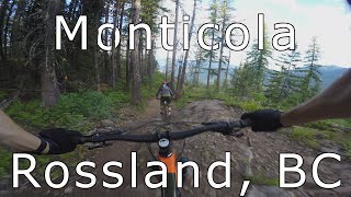
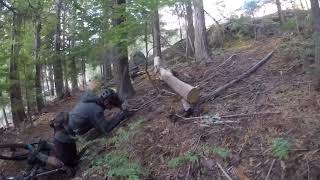
A local favorite, and for good reason. The words fast and flowy may be overused but certainly would't be out of place for this gem. The trail is very buff, manicured, and has many options for all levels of riders including swoopy corners, grade reversals and many pump-able features.

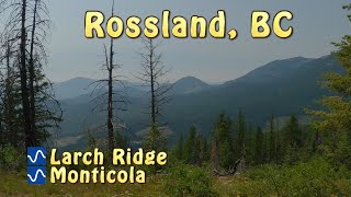
Typically ridden as a loop, starting with Larch Ridge, followed by COG and then back up to the parking area. Alternatively, it can be ridden as a shuttle, with drop-off at the start of Larch Ridge, and pick-up at the bottom of Monticola/COG.

Access Info

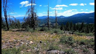
Accessed via Larch Ridge.

Local Trail Association

Recent Activity on Trail

Past Week
  • 6 rides
  • 17.9 km average
6 Months
  • 27 rides
  • 16.1 km avg distance
All
  • 562 rides
  • Last: Jun 29, 2026
c1c2c3c4
January
February
March
April
May
June
July
August
September
October
November
December
update trails status or condition

Monticola Trail Reports

statusdatedescription
Jun 29, 2026 @ 12:52pm (America/Vancouver)
20 hours
Tree down shortly after the rocky sections at the top
Jun 25, 2026 @ 4:29pm (America/Vancouver)
Jun 25, 2026
freshly raked and cut out by the trail crew today..thanks... perfect conditions
Jun 8, 2026 @ 2:31pm (America/Vancouver)
Jun 8, 2026
Unbelievably great work has been done to repair the trail thread on Monticola (especially the Cola Coaster section). Kudos to the Trailcrew.
Jun 5, 2026 @ 7:05am (America/Vancouver)
Jun 5, 2026
reporter We spent the whole week focused on reopening the lower (Cola-coaster) section of Monticola, which after clearing hundreds of trees and ~ 50...
Jun 1, 2026 @ 9:27am (America/Vancouver)
Jun 1, 2026
Few trees down after the last wind storm
more »
Status:
on Jun 29, 2026
Wet
Avg: 4.51 (35 votes)
Your vote: 0

view (3,052)
close
3D
Trail Conditions
  • Unknown
  • Snow Groomed
  • Snow Packed
  • Snow Covered
  • Snow Cover Partial
  • Freeze/thaw Cycle
  • Icy
  • Prevalent Mud
  • Wet
  • Variable
  • Ideal
  • Dry
  • Very Dry
Trail Flow (Ridden Direction)
Trailforks scans users ridelogs to determine the most popular direction each trail is ridden. A good flowing trail network will have most trails flowing in a single direction according to their intension.
The colour categories are based on what percentage of riders are riding a trail in its intended direction.
  • > 96%
  • > 90%
  • > 80%
  • > 70%
  • > 50%
  • < 50%
  • bi-directional trail
  • no data
Trail Last Ridden
Trailforks scans ridelogs to determine the last time a trail was ridden.
  • < 2 days
  • < 1 week
  • < 2 weeks
  • < 1 month
  • < 6 months
  • > 6 months
Trail Ridden Direction
The intended direction a trail should be ridden.
  • Downhill Only
  • Downhill Primary
  • Both Directions
  • Uphill Primary
  • Uphill Only
  • One Direction
Contribute Details
Colors indicate trail is missing specified detail.
  • Description
  • Photos
  • Description & Photos
  • Videos
Trail Popularity ?
Trailforks scans ridelogs to determine which trails are ridden the most in the last 9 months. Trails are compared with nearby trails in the same city region with a possible 25 colour shades. Think of this as a heatmap, more rides = more kinetic energy = warmer colors.
  • most popular
  • popular
  • less popular
  • not popular
ATV/ORV/OHV Filter
Max Vehicle Width
inches
US Cell Coverage
Legend
cell carrier legend

Radar Time
Activity Recordings
Trailforks uses anonymized public activity data. ?
Activity Recordings
Trailforks uses anonymized public activity data. ?
Personal Heatmap
Activity Types
all / none
Options
2
Date range month
Winter Trails
Warning A routing network for winter maps does not exist. Selecting trails using the winter trails layer has been disabled.
Missing Trails
Most Popular
Least Popular
Trails are colored based on popularity. The more popular a trail is, the more red. Less popular trails trend towards green.
Jump Magnitude Heatmap
Heatmap of where riders jump on trails. Zoom in to see individual jumps, click circles to view jump details.
BC Backroad Status

Service Road Atlas is a free to use, community-driven service for viewing and creating reports on the numerous back-country service roads around B.C. and Alberta.

map legend
Slope Aspect
Direction the slope faces
Flat N NE E SE S SW W NW
Trails Deemphasized
Trails are shown in grey.
disable
Only show trails with no bike usage.
Enable
Suggested Layers
Based on selected activity type

    Save the current map location and zoom level as your default home location whenever this page is loaded.

    Save
        Directions to monticola trailhead (49.159600, -117.821440)

        Photos

        28 more »
        1,404 |
        Aug 3, 2014 @ 7:49pm
        Aug 3, 2014
        56 |
        Sep 25, 2024 @ 1:27pm
        Sep 25, 2024
        63 |
        Sep 25, 2024 @ 1:27pm
        Sep 25, 2024
        58 |
        Sep 25, 2024 @ 1:24pm
        Sep 25, 2024

        Videos

        6 more »
        youtuber Monticola - Rossland, BC
        8:36 | 973 | Jul 24, 2020 , Rossland
        Rossland  BC. Larch/Moniticola/COG/ Mxiɬp...
        40:07 | 78 | Aug 18, 2025 , Rossland
        youtuber Larch Ridge and Monticola
        11:52 | 163 | Aug 13, 2024 , Rossland
        Rossland 2019 - Monticola Chest Cam
        2:36 | 485 | Dec 4, 2019 , Rossland

        Trail Lists

        Routes with this trail

        4.7 5 miles 1,054 ft 8 Loop
        begins the loop, starting from Highway 3B, 12 km north of Rossland. The first 2.4 km, is great x-country...
        5 miles 1,044 ft 3 Loop
        Perhaps Rossland's best introduction to the riding to expect here. Only a blue level of difficulty, but...
        36 miles 6,268 ft 58 Shuttled
        Combo of the best climbs and descents in the areas.

        9 Reviews & Comments


        We hope you've been enjoying Trailforks!

        Create a FREE account to view trail comments and much more.

        • By canadakaTF Pro Trailforks & contributors
        • #2185 - 13,444 views

        Frequently Asked Questions About Monticola

        Where is Monticola located?
        Monticola is located in Neptune Creek, Rossland, British Columbia, Canada. It is part of the Neptune Creek trail network. The trailhead is located at coordinates 49.1596, -117.82144.
        How hard is Monticola?
        Monticola is rated as Blue difficulty. The physical rating is Moderate. The average grade is 9.7%.
        What is the elevation gain for Monticola?
        Monticola has 10 m of elevation gain. The trail has 262 m of elevation descent. The elevation ranges from 1,249 m to 1,502 m.
        Is Monticola a point to point trail?
        Yes, Monticola is a point to point trail. The direction is Downhill Only. The trail type is singletrack.

        Hit the Trail

        Open in App

        Get this trail on your phone instantly.
        open trail in app

        Download Trail

        Save to wishlist, Garmin & download.
        save the trail

        Find Related Routes

        Find routes and users activities that include this trail.
        find routes for this trail

        You must enter a description before submitting.