more stats
3.2 miles
Distance
626 ft
Climb
-572 ft
Descent
00:24:49
Avg time
49 ft
Altitude change
1,401 ft
Altitude min
1,773 ft
Altitude max
1,494 ft
Altitude start
1,542 ft
Altitude end
0.3%
Grade
-38.5%
Grade max
36.8%
Grade min
1 mile
Distance climb
1 mile
Distance down
2,228 ft
Distance flat
00:24:49
Avg time

Moon Curser Details

  • Activities
    • Mountain Bike
    • E-Bike
    • Gravel Bike
    • Hike
    • Trail Running
  • Riding Area
    Osoyoos
    , British Columbia
  • Difficulty Rating
  • Local Popularity
    55 in Mountain Biking [+]
    • 80 in E-Biking
    • 5 in Trail Running
    • 5 in Hiking
  • Global Ranking
    #28333 in Mountain Biking [+]
    • #55201 in E-Biking
    • #282783 in Trail Running
    • #324950 in Hiking
  • Hiking SAC Scale
    T1 Hiking
  • Trail Type
    Singletrack
  • Bike Type
    AM, XC, CX, Gravel
  • Direction
    Both Directions
  • Climb Difficulty
    Blue
  • Physical Rating
    Hard
  • Trail Visibility
    Sometimes hard to follow
  • Season
    All year, snow permitting
  • Dogs Allowed
    Yes
  • eBike Allowed
    Yes up to Class 1
  • Ride in Rain
    Yes

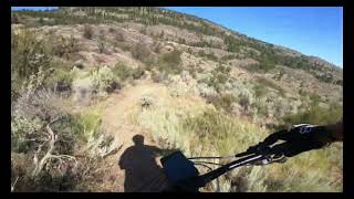
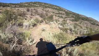
Old school narrow XC trail that affords excellent views of Lake Osoyoos and the town. Mostly non technical, it has some sustained climbs to get that heart pumping Meandering through the sage and antelope, this trail has little shade and is best ridden in Spring, Fall and even the Winter between snow falls. Trail is amazing for Summer night rides but not recommended in the hot hot heat of the day.

Excellent as a there and back but more fun riding Northward. Awesome for trail running and hiking! Bikers please give right of way. The very South end of the trail can be a bit difficult to follow.

Access Info

Access from the parking area near the Osoyoos Gun Range on the North end or off Fairwinds Drive on the South end. Link the Upside Down trail for even more fun

This trail is unsanctioned.

Disclaimer

Unsanctioned, ride at your own risk

Recent Activity on Trail

Past Week
  • 0 rides
  •  
6 Months
  • 1 rides
  • 15 miles avg distance
All
  • 15 rides
  • Last: Apr 22, 2026
c1c2c3c4
January
February
March
April
May
June
July
August
September
October
November
December
update trails status or condition

Moon Curser Trail Reports

statusdatedescription
Dec 3, 2025 @ 4:44pm (America/Vancouver)
Dec 3, 2025
reporter Snow here and there but will hopefully melt soon. Some overgrowth cleared on the South end, more to do. Who's ready for winter riding??
Aug 28, 2025 @ 3:55pm
Aug 28, 2025
Trail Is running pretty good on the northern section - southern section is quite overgrown in spots
Mar 31, 2025 @ 9:33am
Mar 31, 2025
reporter Dry but with some wet spots from spring run off. The trail barely exists past the Cattle trough marked with a Star of TF. Best if ridden as a...
Jan 18, 2025 @ 11:58am
Jan 18, 2025
There is no trail south of the syndicate trail. I made the mistake of traveling from the fairwinds side, and I was completely lost couldn’t find...
Oct 1, 2024 @ 4:59pm
Oct 1, 2024
it's hard to find and stay on the trail but I feel like it could be really fun if more people rode it. really promising, I hope to come back and...
more »
Status:
on Dec 3, 2025
Variable
Avg: 3.99 (5 votes)
Your vote: 0

view (32)
close
3D
Trail Conditions
  • Unknown
  • Snow Groomed
  • Snow Packed
  • Snow Covered
  • Snow Cover Partial
  • Freeze/thaw Cycle
  • Icy
  • Prevalent Mud
  • Wet
  • Variable
  • Ideal
  • Dry
  • Very Dry
Trail Flow (Ridden Direction)
Trailforks scans users ridelogs to determine the most popular direction each trail is ridden. A good flowing trail network will have most trails flowing in a single direction according to their intension.
The colour categories are based on what percentage of riders are riding a trail in its intended direction.
  • > 96%
  • > 90%
  • > 80%
  • > 70%
  • > 50%
  • < 50%
  • bi-directional trail
  • no data
Trail Last Ridden
Trailforks scans ridelogs to determine the last time a trail was ridden.
  • < 2 days
  • < 1 week
  • < 2 weeks
  • < 1 month
  • < 6 months
  • > 6 months
Trail Ridden Direction
The intended direction a trail should be ridden.
  • Downhill Only
  • Downhill Primary
  • Both Directions
  • Uphill Primary
  • Uphill Only
  • One Direction
Contribute Details
Colors indicate trail is missing specified detail.
  • Description
  • Photos
  • Description & Photos
  • Videos
Trail Popularity ?
Trailforks scans ridelogs to determine which trails are ridden the most in the last 9 months. Trails are compared with nearby trails in the same city region with a possible 25 colour shades. Think of this as a heatmap, more rides = more kinetic energy = warmer colors.
  • most popular
  • popular
  • less popular
  • not popular
ATV/ORV/OHV Filter
Max Vehicle Width
inches
US Cell Coverage
Legend
cell carrier legend

Radar Time
Activity Recordings
Trailforks uses anonymized public activity data. ?
Activity Recordings
Trailforks uses anonymized public activity data. ?
Personal Heatmap
Activity Types
all / none
Options
2
Date range month
Winter Trails
Warning A routing network for winter maps does not exist. Selecting trails using the winter trails layer has been disabled.
Missing Trails
Most Popular
Least Popular
Trails are colored based on popularity. The more popular a trail is, the more red. Less popular trails trend towards green.
Jump Magnitude Heatmap
Heatmap of where riders jump on trails. Zoom in to see individual jumps, click circles to view jump details.
BC Backroad Status

Service Road Atlas is a free to use, community-driven service for viewing and creating reports on the numerous back-country service roads around B.C. and Alberta.

map legend
Slope Aspect
Direction the slope faces
Flat N NE E SE S SW W NW
Trails Deemphasized
Trails are shown in grey.
disable
Only show trails with no bike usage.
Enable
Suggested Layers
Based on selected activity type

    Save the current map location and zoom level as your default home location whenever this page is loaded.

    Save
        Directions to moon-curser trailhead (49.004100, -119.490120)

        Photos

        12 more »
        38 |
        Oct 1, 2024 @ 4:57pm
        Oct 1, 2024
        76 |
        Feb 3, 2023 @ 1:37pm
        Feb 3, 2023
        89 |
        Jan 17, 2023 @ 12:04pm
        Jan 17, 2023
        127 |
        Jun 28, 2022 @ 9:50pm
        Jun 28, 2022

        Videos

        3 more »
        Osoyoos - Moon Curser
        2:57 | 300 | Sep 11, 2022 , Osoyoos
        Osoyoos - Moon Curser
        2:57 | 354 | Jul 24, 2022 , Osoyoos
        Osoyoos - Moon Curser
        2:57 | 188 | Jul 24, 2022 , Osoyoos

        2 Reviews & Comments


        We hope you've been enjoying Trailforks!

        Create a FREE account to view trail comments and much more.

        • #519599 - 1,896 views

        Frequently Asked Questions About Moon Curser

        Where is Moon Curser located?
        Moon Curser is located in Osoyoos, British Columbia, Canada. It is part of the Osoyoos trail network. The trailhead is located at coordinates 49.0041, -119.49012.
        How hard is Moon Curser?
        Moon Curser is rated as Blue difficulty. The physical rating is Hard. The average grade is 0.3%. The climb difficulty is rated Blue.
        What is the elevation gain for Moon Curser?
        Moon Curser has 626 ft of elevation gain. The trail has 572 ft of elevation descent. The elevation ranges from 1,401 ft to 1,773 ft.
        Is Moon Curser a point to point trail?
        Moon Curser is not a point to point trail. The direction is Both Directions. The trail type is singletrack.

        Hit the Trail

        Open in App

        Get this trail on your phone instantly.
        open trail in app

        Download Trail

        Save to wishlist, Garmin & download.
        save the trail

        Find Related Routes

        Find routes and users activities that include this trail.
        find routes for this trail

        You must enter a description before submitting.