more stats
1.5 miles
Distance
4 ft
Climb
-635 ft
Descent
00:13:30
Avg time
-632 ft
Altitude change
9,917 ft
Altitude min
10,552 ft
Altitude max
10,548 ft
Altitude start
9,918 ft
Altitude end
-7.9%
Grade
-34.6%
Grade max
3.3%
Grade min
157 ft
Distance climb
1 mile
Distance down
1,073 ft
Distance flat
00:13:30
Avg time

Moonlight Meadows Details

  • Activities
    • Mountain Bike
    • Hike
    • Trail Running
  • Riding Area
    La Sal Mountains
    Moab, Utah
  • Difficulty Rating
  • Voted Difficulty
    Black Diamond (1 vote)
  • Local Popularity
    60 in Mountain Biking [+]
    • 50 in Trail Running
    • 65 in Hiking
  • Global Ranking
    #85905 in Mountain Biking [+]
    • #105324 in Trail Running
    • #111416 in Hiking
  • Trail Type
    Singletrack
  • Bike Type
    AM
  • Direction
    Downhill Primary
    Popular Direction Shown
  • Physical Rating
    Hard
  • Dogs Allowed
    Yes
  • eBike Allowed
  • Land Owner
    USFS

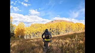
This trail offers alpine meadow views and classic narrow singletrack descents through smooth and chunky trails. The trail starts off kinda flat and through a meadow then starts to drop sending you through aspens groves and back out into lush meadows. The trail is pretty narrow with some blind turns, so watch for hikers.

Trail Supporters

  • USFS
    Land Manager
Local Trail Association
Traditionally Indigenous Territory

Recent Activity on Trail

Past Week
  • 2 rides
  • 30 miles average
6 Months
  • 4 rides
  • 21 miles avg distance
All
  • 59 rides
  • Last: Jun 19, 2026
c1c2c3c4
January
February
March
April
May
June
July
August
September
October
November
December
update trails status or condition

Moonlight Meadows Trail Reports

statusdatedescription
Dec 1, 2025 @ 9:55am (America/Denver)
Dec 1, 2025
reporter
Nov 7, 2024 @ 12:43pm
Nov 7, 2024
reporter
Jun 10, 2024 @ 7:18am
Jun 10, 2024
reporter
Dec 27, 2023 @ 8:39am
Dec 27, 2023
reporter Closed for the season. Usually not open until June at the earliest.
Jun 25, 2023 @ 7:55pm
Jun 25, 2023
reporter Some water on parts of the trail but overall it's dry and running well
more »
Status:
on Dec 1, 2025
Avg: 4.32 (3 votes)
Your vote: 0

view (592)
close
3D
Trail Conditions
  • Unknown
  • Snow Groomed
  • Snow Packed
  • Snow Covered
  • Snow Cover Partial
  • Freeze/thaw Cycle
  • Icy
  • Prevalent Mud
  • Wet
  • Variable
  • Ideal
  • Dry
  • Very Dry
Trail Flow (Ridden Direction)
Trailforks scans users ridelogs to determine the most popular direction each trail is ridden. A good flowing trail network will have most trails flowing in a single direction according to their intension.
The colour categories are based on what percentage of riders are riding a trail in its intended direction.
  • > 96%
  • > 90%
  • > 80%
  • > 70%
  • > 50%
  • < 50%
  • bi-directional trail
  • no data
Trail Last Ridden
Trailforks scans ridelogs to determine the last time a trail was ridden.
  • < 2 days
  • < 1 week
  • < 2 weeks
  • < 1 month
  • < 6 months
  • > 6 months
Trail Ridden Direction
The intended direction a trail should be ridden.
  • Downhill Only
  • Downhill Primary
  • Both Directions
  • Uphill Primary
  • Uphill Only
  • One Direction
Contribute Details
Colors indicate trail is missing specified detail.
  • Description
  • Photos
  • Description & Photos
  • Videos
Trail Popularity ?
Trailforks scans ridelogs to determine which trails are ridden the most in the last 9 months. Trails are compared with nearby trails in the same city region with a possible 25 colour shades. Think of this as a heatmap, more rides = more kinetic energy = warmer colors.
  • most popular
  • popular
  • less popular
  • not popular
ATV/ORV/OHV Filter
Max Vehicle Width
inches
US Cell Coverage
Legend
cell carrier legend

Radar Time
Activity Recordings
Trailforks uses anonymized public activity data. ?
Activity Recordings
Trailforks uses anonymized public activity data. ?
Personal Heatmap
Activity Types
all / none
Options
2
Date range month
Winter Trails
Warning A routing network for winter maps does not exist. Selecting trails using the winter trails layer has been disabled.
Missing Trails
Most Popular
Least Popular
Trails are colored based on popularity. The more popular a trail is, the more red. Less popular trails trend towards green.
Jump Magnitude Heatmap
Heatmap of where riders jump on trails. Zoom in to see individual jumps, click circles to view jump details.
BC Backroad Status

Service Road Atlas is a free to use, community-driven service for viewing and creating reports on the numerous back-country service roads around B.C. and Alberta.

map legend
Slope Aspect
Direction the slope faces
Flat N NE E SE S SW W NW
Trails Deemphasized
Trails are shown in grey.
disable
Only show trails with no bike usage.
Enable
Suggested Layers
Based on selected activity type

    Save the current map location and zoom level as your default home location whenever this page is loaded.

    Save
        Directions to moonlight-meadows trailhead (38.487960, -109.232800)

        Photos

        21 more »
        122 |
        Dec 31, 2019 @ 7:45am
        Dec 31, 2019
        496 |
        Sep 23, 2008 @ 10:47am
        Sep 23, 2008
        111 |
        Sep 9, 2023 @ 2:15pm
        Sep 9, 2023
        60 |
        Sep 9, 2023 @ 11:51am
        Sep 9, 2023

        Videos

        4 more »
        youtuber Best Expert MTB trails in Moab, UT - The...
        16:21 | 221 | Feb 16, 2024 , Moab
        Moonlight Meadows Bike Packing Hut 2 Hut
        0:14 | 89 | Feb 2, 2024 , Moab
        Moonlight Meadows La Sal Mountains Utah
        6:10 | 171 | Feb 4, 2023 , Moab
        Whole Enchilada Alternate?
        11:16 | 203 | Jul 12, 2022 , Moab

        Routes with this trail

        36 miles 1,816 ft 14 Point to Point
        This route is created as a compilation from the San Juan Hut-to-Hut Raptor route and The Whole Enchilada.
        20 miles 2,629 ft 6 Point to Point
        An amazing Moab La Sal Mountain ride that isn't the Enchilada! Start high and end low on this grand tour...
        8 miles 1,838 ft 3

        2 Reviews & Comments


        We hope you've been enjoying Trailforks!

        Create a FREE account to view trail comments and much more.

        • By toddTF Pro Trailforks & contributors
        • #8967 - 6,350 views

        Frequently Asked Questions About Moonlight Meadows

        Where is Moonlight Meadows located?
        Moonlight Meadows is located in La Sal Mountains, Moab, Utah, United States. It is part of the La Sal Mountains trail network. The trailhead is located at coordinates 38.48796, -109.2328.
        How hard is Moonlight Meadows?
        Moonlight Meadows is rated as Black Diamond difficulty. The physical rating is Hard. The average grade is 7.9%.
        What is the elevation gain for Moonlight Meadows?
        Moonlight Meadows has 4 ft of elevation gain. The trail has 635 ft of elevation descent. The elevation ranges from 9,917 ft to 10,552 ft.
        Is Moonlight Meadows a point to point trail?
        Moonlight Meadows is not a point to point trail. The direction is Downhill Primary. The trail type is singletrack.

        Hit the Trail

        Open in App

        Get this trail on your phone instantly.
        open trail in app

        Download Trail

        Save to wishlist, Garmin & download.
        save the trail

        Find Related Routes

        Find routes and users activities that include this trail.
        find routes for this trail

        You must enter a description before submitting.