more stats
4,285 ft
Distance
78 ft
Climb
-198 ft
Descent
00:05:50
Avg time
-120 ft
Altitude change
6,449 ft
Altitude min
6,612 ft
Altitude max
6,612 ft
Altitude start
6,493 ft
Altitude end
-2.8%
Grade
-20.2%
Grade max
16.9%
Grade min
1,158 ft
Distance climb
2,789 ft
Distance down
338 ft
Distance flat
00:05:50
Avg time

High Meadows OHV Trail Details

  • Activities
    • Mountain Bike
    • E-Bike
    • Gravel Bike
    • Adaptive Bike
    • Horse
    • Hike
    • Trail Running
    • Dirtbike/Moto
    • ATV/ORV/OHV
  • Riding Area
    Powerline
    South Lake Tahoe, California
  • Ref Number
    18E33A
  • Difficulty Rating
  • Local Popularity
    85 in Mountain Biking [+]
    • 85 in E-Biking
    • 70 in Trail Running
    • 60 in Hiking
    • 90 in Dirtbiking
    • 5 in ATVing/Offroading
    • 5 in Horseback
  • Global Ranking
    #70039 in Mountain Biking [+]
    • #36219 in E-Biking
    • #78132 in Trail Running
    • #97577 in Hiking
    • #3429 in Dirtbiking
    • #251 in ATVing/Offroading
    • #2636 in Horseback
  • Hiking SAC Scale
    T1 Hiking
  • Trail Type
    Doubletrack
  • Bike Type
    AM, XC, Adaptive MTB, Gravel
  • Direction
    Both Directions[+]
    • Both Directions for Gravel Biking
  • Climb Difficulty
    Blue
  • Physical Rating
    Moderate
  • Trail Visibility
    Always easy to follow
  • Season
    May-November
  • Dogs Allowed
    Yes
  • eBike Allowed
  • Land Owner
    USFS Lake Tahoe Basin Management Unit
  • Vehicle Info
  • Max Width
    50 inches
  • License
    Not Required

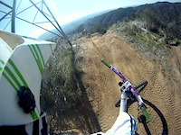
This is a very fun, high banked moto trail that is appropriate for all rider levels depending on how fast it is taken. It's also a continuation of the Powerline Trail and provides access to Powerline Road and subsequently to the Corral network of trails. This trail becomes very sandy and loose in summer, so riding up is usually frustrating.

Access Info

Look for the prominent forest service trailhead sign approximately a quarter mile up the High Meadow forest access road. The lower end of this trail morphs into the Powerline Road.

Adaptive Bike Info
aMTB Green Rating: Beginner features and moderate terrain.

This trail has ATV/ dirt bike traffic. It is a fun downhill with berms and rollers or a steep climb.

Trail Supporters

  • USFS
    Land Manager
Local Trail Association
Traditionally Indigenous Territory

Recent Activity on Trail

Past Week
  • 0 rides
  •  
6 Months
  • 21 rides
  • 17 miles avg distance
All
  • 380 rides
  • Last: Jun 16, 2026
c1c2c3c4
January
February
March
April
May
June
July
August
September
October
November
December
Status:
on Nov 9, 2025
Dry
Avg: 4.1 (3 votes)
Your vote: 0

view (1,908)
close
3D
Trail Conditions
  • Unknown
  • Snow Groomed
  • Snow Packed
  • Snow Covered
  • Snow Cover Partial
  • Freeze/thaw Cycle
  • Icy
  • Prevalent Mud
  • Wet
  • Variable
  • Ideal
  • Dry
  • Very Dry
Trail Flow (Ridden Direction)
Trailforks scans users ridelogs to determine the most popular direction each trail is ridden. A good flowing trail network will have most trails flowing in a single direction according to their intension.
The colour categories are based on what percentage of riders are riding a trail in its intended direction.
  • > 96%
  • > 90%
  • > 80%
  • > 70%
  • > 50%
  • < 50%
  • bi-directional trail
  • no data
Trail Last Ridden
Trailforks scans ridelogs to determine the last time a trail was ridden.
  • < 2 days
  • < 1 week
  • < 2 weeks
  • < 1 month
  • < 6 months
  • > 6 months
Trail Ridden Direction
The intended direction a trail should be ridden.
  • Downhill Only
  • Downhill Primary
  • Both Directions
  • Uphill Primary
  • Uphill Only
  • One Direction
Contribute Details
Colors indicate trail is missing specified detail.
  • Description
  • Photos
  • Description & Photos
  • Videos
Trail Popularity ?
Trailforks scans ridelogs to determine which trails are ridden the most in the last 9 months. Trails are compared with nearby trails in the same city region with a possible 25 colour shades. Think of this as a heatmap, more rides = more kinetic energy = warmer colors.
  • most popular
  • popular
  • less popular
  • not popular
ATV/ORV/OHV Filter
Max Vehicle Width
inches
US Cell Coverage
Legend
cell carrier legend

Radar Time
Activity Recordings
Trailforks uses anonymized public activity data. ?
Activity Recordings
Trailforks uses anonymized public activity data. ?
Personal Heatmap
Activity Types
all / none
Options
2
Date range month
Winter Trails
Warning A routing network for winter maps does not exist. Selecting trails using the winter trails layer has been disabled.
Missing Trails
Most Popular
Least Popular
Trails are colored based on popularity. The more popular a trail is, the more red. Less popular trails trend towards green.
Jump Magnitude Heatmap
Heatmap of where riders jump on trails. Zoom in to see individual jumps, click circles to view jump details.
BC Backroad Status

Service Road Atlas is a free to use, community-driven service for viewing and creating reports on the numerous back-country service roads around B.C. and Alberta.

map legend
Slope Aspect
Direction the slope faces
Flat N NE E SE S SW W NW
Trails Deemphasized
Trails are shown in grey.
disable
Only show trails with no bike usage.
Enable
Suggested Layers
Based on selected activity type

    Save the current map location and zoom level as your default home location whenever this page is loaded.

    Save
        Directions to high-meadows-ohv-trail trailhead (38.896430, -119.953250)

        Photos

        No photos have been added for High Meadows OHV Trail yet, add a photo.

        Videos

        1 more »
        Powerline
        3:21 | 489 | Mar 4, 2012 , South Lake Tahoe

        Routes with this trail

        4.0 20 miles 3,223 ft 26
        For 2019, the Tahoe Triple Crown Ride has transformed into a butterfly. TAMBA & USFS have been monitoring...
        43 miles 7,335 ft 12
        to TRT and Monument Pass, descent to Cold Creek, up Insence Cedar, up to Armstrong Pass, to Toads, to...
        1.0 13 miles 1,903 ft 17 Loop
        Leaving from Fountain Place Road/Power Line Road parking lot at 9:15-9:30. Mellow but steady pace. We will...

        1 Review & Comments


        We hope you've been enjoying Trailforks!

        Create a FREE account to view trail comments and much more.

        • By TheAngryTomatoTF Pro TRAILFORKS & contributors
        • #24358 - 4,635 views

        Frequently Asked Questions About High Meadows OHV Trail

        Where is High Meadows OHV Trail located?
        High Meadows OHV Trail is located in Powerline, South Lake Tahoe, California, United States. It is part of the Powerline trail network. The trailhead is located at coordinates 38.89643, -119.95325.
        How hard is High Meadows OHV Trail?
        High Meadows OHV Trail is rated as Blue difficulty. The physical rating is Moderate. The average grade is 2.8%. The climb difficulty is rated Blue.
        What is the elevation gain for High Meadows OHV Trail?
        High Meadows OHV Trail has 78 ft of elevation gain. The trail has 198 ft of elevation descent. The elevation ranges from 6,449 ft to 6,612 ft.
        Is High Meadows OHV Trail a point to point trail?
        High Meadows OHV Trail is not a point to point trail. The direction is Both Directions. The trail type is doubletrack.

        Hit the Trail

        Open in App

        Get this trail on your phone instantly.
        open trail in app

        Download Trail

        Save to wishlist, Garmin & download.
        save the trail

        Find Related Routes

        Find routes and users activities that include this trail.
        find routes for this trail

        You must enter a description before submitting.