more stats
2.2 miles
Distance
2,260 ft
Climb
-56 ft
Descent
00:59:54
Avg time
2,211 ft
Altitude change
6,023 ft
Altitude min
8,235 ft
Altitude max
6,023 ft
Altitude start
8,235 ft
Altitude end
19.4%
Grade
-20.4%
Grade max
77.7%
Grade min
2 miles
Distance climb
869 ft
Distance down
105 ft
Distance flat
00:59:54
Avg time

Mount Burke Trail Details

  • Activities
    • Mountain Bike
    • Hike
    • Trail Running
  • Riding Area
    Cataract Creek
    Alberta
  • Difficulty Rating
  • Local Popularity
    75 in Mountain Biking [+]
    • 70 in Trail Running
    • 70 in Hiking
  • Global Ranking
    #182981 in Mountain Biking [+]
    • #80271 in Trail Running
    • #74012 in Hiking
  • Trail Type
    Singletrack
  • Bike Type
    AM, XC
  • Direction
    Both Directions
  • Climb Difficulty
    Double Black Diamond
  • Physical Rating
    Hard
  • Dogs Allowed
    Yes
  • Land Owner
    Alberta Parks

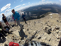
Things may have changed since the 2013 floods, but there is some great riding up high on the ridge

Access Info

The 2013 floods might have blown out the creek more than the 1995 floods, but the rest of the trail should be unaffected.

Recent Activity on Trail

Past Week
  • 0 rides
  •  
6 Months
  • 1 rides
  • 8 miles avg distance
All
  • 11 rides
  • Last: Jun 14, 2026
c1c2c3c4
January
February
March
April
May
June
July
August
September
October
November
December
update trails status or condition

Mount Burke Trail Trail Reports

statusdatedescription
Jun 14, 2026 @ 11:02pm (America/Edmonton)
Jun 14, 2026
In great shape. Removed a few downed trees from the Slater Creek and New Mount Burke trails. Dry conditions. Bit of snow remaining at the top. ...
Jul 6, 2024 @ 6:44pm
Jul 6, 2024
In excellent shape, no deadfall on Slater Creek and the Mt Burke New Trail. I climbed and descended on Slater Creek and the Mt Burke New Trail...
Nov 30, 2023 @ 9:30am
Nov 30, 2023
Sep 10, 2023 @ 8:55pm
Sep 10, 2023
Was a fun trail. Comparable in some ways to Blackrock, but the upper scree /rock section of Mt Burke is not as steep as Blackrock and it is...
Jul 17, 2022 @ 8:11am
Jul 17, 2022
Fantastic ride. Very worth while doing. Prepare yourself for the first 2 km following the trails that are posted on Trailforks to suck. You will...
more »
Status:
on Jun 14, 2026
Dry
no votes yet
Your vote: 0

view (71)
close
3D
Trail Conditions
  • Unknown
  • Snow Groomed
  • Snow Packed
  • Snow Covered
  • Snow Cover Partial
  • Freeze/thaw Cycle
  • Icy
  • Prevalent Mud
  • Wet
  • Variable
  • Ideal
  • Dry
  • Very Dry
Trail Flow (Ridden Direction)
Trailforks scans users ridelogs to determine the most popular direction each trail is ridden. A good flowing trail network will have most trails flowing in a single direction according to their intension.
The colour categories are based on what percentage of riders are riding a trail in its intended direction.
  • > 96%
  • > 90%
  • > 80%
  • > 70%
  • > 50%
  • < 50%
  • bi-directional trail
  • no data
Trail Last Ridden
Trailforks scans ridelogs to determine the last time a trail was ridden.
  • < 2 days
  • < 1 week
  • < 2 weeks
  • < 1 month
  • < 6 months
  • > 6 months
Trail Ridden Direction
The intended direction a trail should be ridden.
  • Downhill Only
  • Downhill Primary
  • Both Directions
  • Uphill Primary
  • Uphill Only
  • One Direction
Contribute Details
Colors indicate trail is missing specified detail.
  • Description
  • Photos
  • Description & Photos
  • Videos
Trail Popularity ?
Trailforks scans ridelogs to determine which trails are ridden the most in the last 9 months. Trails are compared with nearby trails in the same city region with a possible 25 colour shades. Think of this as a heatmap, more rides = more kinetic energy = warmer colors.
  • most popular
  • popular
  • less popular
  • not popular
ATV/ORV/OHV Filter
Max Vehicle Width
inches
US Cell Coverage
Legend
cell carrier legend

Radar Time
Activity Recordings
Trailforks uses anonymized public activity data. ?
Activity Recordings
Trailforks uses anonymized public activity data. ?
Personal Heatmap
Activity Types
all / none
Options
2
Date range month
Winter Trails
Warning A routing network for winter maps does not exist. Selecting trails using the winter trails layer has been disabled.
Missing Trails
Most Popular
Least Popular
Trails are colored based on popularity. The more popular a trail is, the more red. Less popular trails trend towards green.
Jump Magnitude Heatmap
Heatmap of where riders jump on trails. Zoom in to see individual jumps, click circles to view jump details.
BC Backroad Status

Service Road Atlas is a free to use, community-driven service for viewing and creating reports on the numerous back-country service roads around B.C. and Alberta.

map legend
Slope Aspect
Direction the slope faces
Flat N NE E SE S SW W NW
Trails Deemphasized
Trails are shown in grey.
disable
Only show trails with no bike usage.
Enable
Suggested Layers
Based on selected activity type

    Save the current map location and zoom level as your default home location whenever this page is loaded.

    Save
        Directions to mount-burke-trail trailhead (50.283290, -114.556070)

        Photos

        30 more »
        460 |
        Jun 25, 2018 @ 4:09pm
        Jun 25, 2018
        581 |
        Sep 30, 2012 @ 4:44pm
        Sep 30, 2012
        243 |
        Aug 26, 2020 @ 10:11am
        Aug 26, 2020
        197 |
        Aug 26, 2020 @ 10:11am
        Aug 26, 2020

        Videos

        1 more »
        Mt Burke
        10:19 | 998 | May 25, 2015 , My City

        2 Reviews & Comments


        We hope you've been enjoying Trailforks!

        Create a FREE account to view trail comments and much more.

        • By racerfacerTF Pro & contributors
        • #32900 - 5,022 views

        Frequently Asked Questions About Mount Burke Trail

        Where is Mount Burke Trail located?
        Mount Burke Trail is located in Cataract Creek, Alberta, Canada. It is part of the Cataract Creek trail network. The trailhead is located at coordinates 50.28329, -114.55607.
        How hard is Mount Burke Trail?
        Mount Burke Trail is rated as Black Diamond difficulty. The physical rating is Hard. The average grade is 19.4%. The climb difficulty is rated Double Black Diamond.
        What is the elevation gain for Mount Burke Trail?
        Mount Burke Trail has 2,260 ft of elevation gain. The trail has 56 ft of elevation descent. The elevation ranges from 6,023 ft to 8,235 ft.
        Is Mount Burke Trail a point to point trail?
        Mount Burke Trail is not a point to point trail. The direction is Both Directions. The trail type is singletrack.

        Hit the Trail

        Open in App

        Get this trail on your phone instantly.
        open trail in app

        Download Trail

        Save to wishlist, Garmin & download.
        save the trail

        Find Related Routes

        Find routes and users activities that include this trail.
        find routes for this trail

        You must enter a description before submitting.