more stats
3,042 ft
Distance
322 ft
Climb
-11 ft
Descent
00:10:43
Avg time
311 ft
Altitude change
4,816 ft
Altitude min
5,127 ft
Altitude max
4,816 ft
Altitude start
5,127 ft
Altitude end
10.215%
Grade
-4.345%
Grade max
24.973%
Grade min
2,613 ft
Distance climb
291 ft
Distance down
138 ft
Distance flat
00:10:43
Avg time

Mount Sentinel Summit Details

  • Activities
    • Mountain Bike
    • Winter Fat Bike
    • Hike
    • Trail Running
    • Snowshoe
  • Riding Area
    Pattee Canyon
    Missoula, Montana
  • Difficulty Rating
  • Local Popularity
    85 in Mountain Biking [+]
    • 100 in Trail Running
    • 100 in Hiking
    • 5 in Snowshoeing
  • Global Ranking
    #79605 in Mountain Biking [+]
    • #2194 in Trail Running
    • #5017 in Hiking
  • Hiking SAC Scale
    T2 Mountain Hiking
  • Trail Type
    Singletrack
  • Snow Grooming
    Backcountry
  • Bike Type
    AM, XC, Fat
  • Direction
    Both Directions
  • Climb Difficulty
    Blue
  • Physical Rating
    Moderate
  • Trail Visibility
    Always easy to follow
  • Season
    Non-winter
  • Alpine Trail
    Yes
  • Family Friendly
    Yes
  • Dogs Allowed
    Yes
  • eBike Allowed
  • Land Owner
    University of Montana

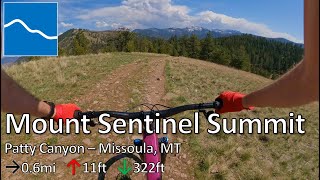
This is a great out and back trail that takes you to the very summit of Mount Sentinel from its eastern saddle. There are a couple of steep sections, so give yourself a pat on the back if you make it without dabs. Take in the awesome view of the Missoula Valley and then enjoy the fast (and sometimes loose) descent back to the saddle. This is a popular multi-use trail, so be vigilant and courteous to other users. This short trail is one of the crown jewels of the Pattee Canyon system, so keeping it open to bicycles is important.

Trail Supporters
Local Trail Association
Traditionally Indigenous Territory

Recent Activity on Trail

Past Week
  • 1 rides
  • 10 miles average
6 Months
  • 16 rides
  • 11 miles avg distance
All
  • 176 rides
  • Last: Jun 18, 2026
c1c2c3c4
January
February
March
April
May
June
July
August
September
October
November
December
Status:
on Jun 2, 2026
Ideal
Avg: 3.99 (3 votes)
Your vote: 0

view (3,025)
close
3D
Trail Conditions
  • Unknown
  • Snow Groomed
  • Snow Packed
  • Snow Covered
  • Snow Cover Partial
  • Freeze/thaw Cycle
  • Icy
  • Prevalent Mud
  • Wet
  • Variable
  • Ideal
  • Dry
  • Very Dry
Trail Flow (Ridden Direction)
Trailforks scans users ridelogs to determine the most popular direction each trail is ridden. A good flowing trail network will have most trails flowing in a single direction according to their intension.
The colour categories are based on what percentage of riders are riding a trail in its intended direction.
  • > 96%
  • > 90%
  • > 80%
  • > 70%
  • > 50%
  • < 50%
  • bi-directional trail
  • no data
Trail Last Ridden
Trailforks scans ridelogs to determine the last time a trail was ridden.
  • < 2 days
  • < 1 week
  • < 2 weeks
  • < 1 month
  • < 6 months
  • > 6 months
Trail Ridden Direction
The intended direction a trail should be ridden.
  • Downhill Only
  • Downhill Primary
  • Both Directions
  • Uphill Primary
  • Uphill Only
  • One Direction
Contribute Details
Colors indicate trail is missing specified detail.
  • Description
  • Photos
  • Description & Photos
  • Videos
Trail Popularity ?
Trailforks scans ridelogs to determine which trails are ridden the most in the last 9 months. Trails are compared with nearby trails in the same city region with a possible 25 colour shades. Think of this as a heatmap, more rides = more kinetic energy = warmer colors.
  • most popular
  • popular
  • less popular
  • not popular
ATV/ORV/OHV Filter
Max Vehicle Width
inches
US Cell Coverage
Legend
cell carrier legend

Radar Time
Activity Recordings
Trailforks uses anonymized public activity data. ?
Activity Recordings
Trailforks uses anonymized public activity data. ?
Personal Heatmap
Activity Types
all / none
Options
2
Date range month
Winter Trails
Warning A routing network for winter maps does not exist. Selecting trails using the winter trails layer has been disabled.
Missing Trails
Most Popular
Least Popular
Trails are colored based on popularity. The more popular a trail is, the more red. Less popular trails trend towards green.
Jump Magnitude Heatmap
Heatmap of where riders jump on trails. Zoom in to see individual jumps, click circles to view jump details.
BC Backroad Status

Service Road Atlas is a free to use, community-driven service for viewing and creating reports on the numerous back-country service roads around B.C. and Alberta.

map legend
Slope Aspect
Direction the slope faces
Flat N NE E SE S SW W NW
Trails Deemphasized
Trails are shown in grey.
disable
Only show trails with no bike usage.
Enable
Suggested Layers
Based on selected activity type

    Save the current map location and zoom level as your default home location whenever this page is loaded.

    Save
        Directions to mount-sentinel-summit trailhead (46.850040, -113.955050)

        Photos

        4 more »
        38 |
        May 14, 2024 @ 6:55pm
        May 14, 2024
        130 |
        Apr 25, 2020 @ 3:49pm
        Apr 25, 2020
        102 |
        Apr 25, 2020 @ 3:49pm
        Apr 25, 2020
        217 |
        Feb 19, 2019 @ 1:22pm
        Feb 19, 2019

        Videos

        1 more »
        youtuber Mount Sentinel Summit - Pattee Canyon -...
        3:10 | 189 | Apr 19, 2024 , Missoula

        Routes with this trail

        1.0 4 miles 1,290 ft 5 Out & Back
        A fun way to get to the top of Mount Sentinel starting from Crazy Canyon. This uses a few of the side...
        2.0 11 miles 2,236 ft 21
        This route represents a popular way to start from town and ride to the top of Mt. Sentinel. The climb is a...

        Reviews / Comments

        No reviews yet, be the first to write a review or ask a question.
        Use trail reports to comment on trail conditions.


        We hope you've been enjoying Trailforks!

        Create a FREE account to view trail comments and much more.

        • By FandersonTF Pro & contributors
        • #124010 - 2,461 views

        Frequently Asked Questions About Mount Sentinel Summit

        Where is Mount Sentinel Summit located?
        Mount Sentinel Summit is located in Pattee Canyon, Missoula, Montana, United States. It is part of the Pattee Canyon trail network. The trailhead is located at coordinates 46.85004, -113.95505.
        How hard is Mount Sentinel Summit?
        Mount Sentinel Summit is rated as Blue difficulty. The physical rating is Moderate. The average grade is 10.215%. The climb difficulty is rated Blue.
        What is the elevation gain for Mount Sentinel Summit?
        Mount Sentinel Summit has 322 ft of elevation gain. The trail has 11 ft of elevation descent. The elevation ranges from 4,816 ft to 5,127 ft.
        Is Mount Sentinel Summit a point to point trail?
        Mount Sentinel Summit is not a point to point trail. The direction is Both Directions. The trail type is singletrack.

        Hit the Trail

        Open in App

        Get this trail on your phone instantly.
        open trail in app

        Download Trail

        Save to wishlist, Garmin & download.
        save the trail

        Find Related Routes

        Find routes and users activities that include this trail.
        find routes for this trail

        You must enter a description before submitting.