


Open in App
Get this trail on your phone instantly.

The shortest and most popular route to climb Mt. Whitney is a 10.7 mile (17.1 km) trail from Whitney Portal, 13 miles (21 km) west of the town of Lone Pine on the east side of the Sierra. Ice axes and crampons are needed in spring and early summer, but technical climbing equipment is not usually necessary between mid-July and early October. The elevation at the trailhead is 8360' (2550 meters). The elevation at the summit is 14,494' (4418 meters).
There are other routes besides Whitney Portal that lead to Mt. Whitney. They begin at less heavily-used trailheads, but require a much longer hike to reach the summit. The High Sierra Trail leaves from Giant Forest on the west side of Sequoia National Park, and is about 60 miles (100 km) one-way. It takes a minimum of 6 days (one way) or 10 days (round trip) to complete
| c1 | c2 | c3 | c4 |
|---|---|---|---|
January | February | March | April |
May | June | July | August |
September | October | November | December |

Service Road Atlas is a free to use, community-driven service for viewing and creating reports on the numerous back-country service roads around B.C. and Alberta.
Save the current map location and zoom level as your default home location whenever this page is loaded.
Save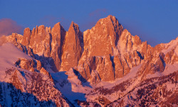

No reviews yet, be the first to write a review or ask a question.
Use trail reports to comment on trail conditions.
We hope you've been enjoying Trailforks!
Create a FREE account to view trail comments and much more.
You must enter a description before submitting.

