more stats
1,736 ft
Distance
-285 ft
Descent
00:10:31
Avg time
-285 ft
Altitude change
487 ft
Altitude min
773 ft
Altitude max
773 ft
Altitude start
489 ft
Altitude end
-16.4%
Grade
-37%
Grade max
0.8%
Grade min
36 ft
Distance climb
1,634 ft
Distance down
00:10:31
Avg time

Mountain of Phlegm Details

  • Activities
    • Mountain Bike
    • E-Bike
    • Hike
    • Trail Running
    • Observed Trials
  • Riding Area
    Valleycliffe
    Squamish, British Columbia
  • Difficulty Rating
  • Local Popularity
    70 in Mountain Biking [+]
    • 60 in E-Biking
    • 90 in Trail Running
    • 90 in Hiking
    • 90 in Observed Trials
  • Global Ranking
    #82668 in Mountain Biking [+]
    • #75244 in E-Biking
    • #3497 in Trail Running
    • #36863 in Hiking
    • #125 in Observed Trials
  • Hiking SAC Scale
    T2 Mountain Hiking
  • Trail Type
    Singletrack
  • Bike Type
    DH, AM
  • Direction
    Both Directions
  • Climb Difficulty
    Double Black Diamond
  • Physical Rating
    Extreme
  • Trail Visibility
    Sometimes hard to follow
  • Dogs Allowed
    Yes
  • eBike Allowed
    Yes up to Class 1
  • TTFs on Trail
    Rock Face
  • Land Owner
    Diamond Head Land Co

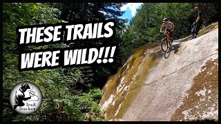
A fun descent with small rock slabs scattered along the trail. But can also be used as a steep technical climb, the most efficient climbing route to the top of the hill. You'll be pushing your bike in several sections unless you're a super hero with trials skills.

This trail is unsanctioned.

Traditionally Indigenous Territory

Recent Activity on Trail

Past Week
  • 2 rides
  • 6 miles average
6 Months
  • 52 rides
  • 7 miles avg distance
All
  • 360 rides
  • Last: Jun 25, 2026
c1c2c3c4
January
February
March
April
May
June
July
August
September
October
November
December
update trails status or condition

Mountain of Phlegm Trail Reports

Status:
on Sep 22, 2025
Ideal
Avg: 3.77 (12 votes)
Your vote: 0

view (3,304)
close
3D
Trail Conditions
  • Unknown
  • Snow Groomed
  • Snow Packed
  • Snow Covered
  • Snow Cover Partial
  • Freeze/thaw Cycle
  • Icy
  • Prevalent Mud
  • Wet
  • Variable
  • Ideal
  • Dry
  • Very Dry
Trail Flow (Ridden Direction)
Trailforks scans users ridelogs to determine the most popular direction each trail is ridden. A good flowing trail network will have most trails flowing in a single direction according to their intension.
The colour categories are based on what percentage of riders are riding a trail in its intended direction.
  • > 96%
  • > 90%
  • > 80%
  • > 70%
  • > 50%
  • < 50%
  • bi-directional trail
  • no data
Trail Last Ridden
Trailforks scans ridelogs to determine the last time a trail was ridden.
  • < 2 days
  • < 1 week
  • < 2 weeks
  • < 1 month
  • < 6 months
  • > 6 months
Trail Ridden Direction
The intended direction a trail should be ridden.
  • Downhill Only
  • Downhill Primary
  • Both Directions
  • Uphill Primary
  • Uphill Only
  • One Direction
Contribute Details
Colors indicate trail is missing specified detail.
  • Description
  • Photos
  • Description & Photos
  • Videos
Trail Popularity ?
Trailforks scans ridelogs to determine which trails are ridden the most in the last 9 months. Trails are compared with nearby trails in the same city region with a possible 25 colour shades. Think of this as a heatmap, more rides = more kinetic energy = warmer colors.
  • most popular
  • popular
  • less popular
  • not popular
ATV/ORV/OHV Filter
Max Vehicle Width
inches
US Cell Coverage
Legend
cell carrier legend

Radar Time
Activity Recordings
Trailforks uses anonymized public activity data. ?
Activity Recordings
Trailforks uses anonymized public activity data. ?
Personal Heatmap
Activity Types
all / none
Options
2
Date range month
Winter Trails
Warning A routing network for winter maps does not exist. Selecting trails using the winter trails layer has been disabled.
Missing Trails
Most Popular
Least Popular
Trails are colored based on popularity. The more popular a trail is, the more red. Less popular trails trend towards green.
Jump Magnitude Heatmap
Heatmap of where riders jump on trails. Zoom in to see individual jumps, click circles to view jump details.
BC Backroad Status

Service Road Atlas is a free to use, community-driven service for viewing and creating reports on the numerous back-country service roads around B.C. and Alberta.

map legend
Slope Aspect
Direction the slope faces
Flat N NE E SE S SW W NW
Trails Deemphasized
Trails are shown in grey.
disable
Only show trails with no bike usage.
Enable
Suggested Layers
Based on selected activity type

    Save the current map location and zoom level as your default home location whenever this page is loaded.

    Save
        Directions to mountain-phlegm trailhead (49.708550, -123.133930)

        Photos

        30 more »
        194 |
        Apr 18, 2020 @ 6:11pm
        Apr 18, 2020
        155 |
        Mar 22, 2020 @ 12:11am
        Mar 22, 2020
        91 |
        Feb 10, 2024 @ 9:48pm
        Feb 10, 2024
        183 |
        Apr 18, 2020 @ 6:11pm
        Apr 18, 2020

        Videos

        1 more »
        youtuber Checking out a a totally different area and...
        8:13 | 279 | Sep 20, 2023 , Squamish

        Routes with this trail

        4.0 32 miles 7,408 ft 45
        https://squamish50.com/50-km/
        4 miles 1,032 ft 7 Loop
        Balsam-Valleycliffe-Loop for Garmin Fenix 6 Route
        27 miles 5,990 ft 35
        Training for the Squamish 50 miler

        Trail Products

        1 Review & Comments


        We hope you've been enjoying Trailforks!

        Create a FREE account to view trail comments and much more.

        • #1109 - 6,363 views

        Frequently Asked Questions About Mountain of Phlegm

        Where is Mountain of Phlegm located?
        Mountain of Phlegm is located in Valleycliffe, Squamish, British Columbia, Canada. It is part of the Valleycliffe trail network. The trailhead is located at coordinates 49.70855, -123.13393.
        How hard is Mountain of Phlegm?
        Mountain of Phlegm is rated as Black Diamond difficulty. The physical rating is Extreme. The average grade is 16.4%. The climb difficulty is rated Double Black Diamond.
        What is the elevation gain for Mountain of Phlegm?
        The trail has 285 ft of elevation descent. The elevation ranges from 487 ft to 773 ft.
        Is Mountain of Phlegm a point to point trail?
        Mountain of Phlegm is not a point to point trail. The direction is Both Directions. The trail type is singletrack.

        Hit the Trail

        Open in App

        Get this trail on your phone instantly.
        open trail in app

        Download Trail

        Save to wishlist, Garmin & download.
        save the trail

        Find Related Routes

        Find routes and users activities that include this trail.
        find routes for this trail

        You must enter a description before submitting.