more stats
1.1 miles
Distance
232 ft
Climb
-773 ft
Descent
00:03:54
Avg time
-541 ft
Altitude change
997 ft
Altitude min
1,538 ft
Altitude max
1,538 ft
Altitude start
997 ft
Altitude end
-9.542%
Grade
-52.219%
Grade max
33.034%
Grade min
1,671 ft
Distance climb
3,810 ft
Distance down
189 ft
Distance flat
00:03:54
Avg time

Mr Black Details

  • Activities
    • Mountain Bike
    • E-Bike
  • Riding Area
  • Difficulty Rating
  • Local Popularity
    90 in Mountain Biking [+]
    • 60 in E-Biking
  • Global Ranking
    #35167 in Mountain Biking [+]
    • #69880 in E-Biking
  • Trail Type
    Machine Groomed
  • Bike Type
    DH, AM, DJ
  • Direction
    Downhill Primary
    Popular Direction Shown
  • Physical Rating
    Hard
  • Dogs Allowed
    Yes
  • eBike Allowed
    Yes up to Class 1
  • TTFs on Trail
    Berm, Bridge, Drop, Jump, Gap Jump, Log Ride, Skinny, Wallride
  • Year Opened
    2016

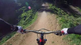
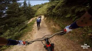
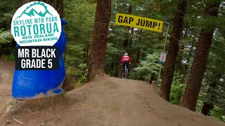
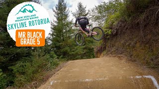
From Simple Jack to Mr. Black, discover the epic transformation at Skyline Rotorua Gravity Park and ride the new line that boasts 32 jumpable features including tables, step downs, step ups, sharks fins, doubles, as well as a road gap and wall ride, all connected by massive sculpted berms.

Access Info

Skyline Gondola

Trail Supporters
  • Empire Of Dirt
    Builder

Bike Park

Recent Activity on Trail

Past Week
  • 2 rides
  • 26.0 km average
6 Months
  • 29 rides
  • 19.9 km avg distance
All
  • 219 rides
  • Last: Jun 13, 2026
c1c2c3c4
January
February
March
April
May
June
July
August
September
October
November
December
update trails status or condition

Mr Black Trail Reports

statusdatedescription
Jul 28, 2024 @ 3:51pm
Jul 28, 2024
Jul 20, 2023 @ 6:02am
Jul 20, 2023
Fun and fast.
Mar 3, 2023 @ 1:51pm
Mar 3, 2023
Aug 8, 2021 @ 10:55pm
Aug 8, 2021
Opening berm is a bit slippery and rutted, but once you’re through that the whole trail is running mint!
Oct 24, 2020 @ 5:45pm
Oct 24, 2020
more »
Status:
on Jul 28, 2024
Ideal
Avg: 4.47 (13 votes)
Your vote: 0

view (6,358)
close
3D
Trail Conditions
  • Unknown
  • Snow Groomed
  • Snow Packed
  • Snow Covered
  • Snow Cover Partial
  • Freeze/thaw Cycle
  • Icy
  • Prevalent Mud
  • Wet
  • Variable
  • Ideal
  • Dry
  • Very Dry
Trail Flow (Ridden Direction)
Trailforks scans users ridelogs to determine the most popular direction each trail is ridden. A good flowing trail network will have most trails flowing in a single direction according to their intension.
The colour categories are based on what percentage of riders are riding a trail in its intended direction.
  • > 96%
  • > 90%
  • > 80%
  • > 70%
  • > 50%
  • < 50%
  • bi-directional trail
  • no data
Trail Last Ridden
Trailforks scans ridelogs to determine the last time a trail was ridden.
  • < 2 days
  • < 1 week
  • < 2 weeks
  • < 1 month
  • < 6 months
  • > 6 months
Trail Ridden Direction
The intended direction a trail should be ridden.
  • Downhill Only
  • Downhill Primary
  • Both Directions
  • Uphill Primary
  • Uphill Only
  • One Direction
Contribute Details
Colors indicate trail is missing specified detail.
  • Description
  • Photos
  • Description & Photos
  • Videos
Trail Popularity ?
Trailforks scans ridelogs to determine which trails are ridden the most in the last 9 months. Trails are compared with nearby trails in the same city region with a possible 25 colour shades. Think of this as a heatmap, more rides = more kinetic energy = warmer colors.
  • most popular
  • popular
  • less popular
  • not popular
ATV/ORV/OHV Filter
Max Vehicle Width
inches
US Cell Coverage
Legend
cell carrier legend

Radar Time
Activity Recordings
Trailforks uses anonymized public activity data. ?
Activity Recordings
Trailforks uses anonymized public activity data. ?
Personal Heatmap
Activity Types
all / none
Options
2
Date range month
Winter Trails
Warning A routing network for winter maps does not exist. Selecting trails using the winter trails layer has been disabled.
Missing Trails
Most Popular
Least Popular
Trails are colored based on popularity. The more popular a trail is, the more red. Less popular trails trend towards green.
Jump Magnitude Heatmap
Heatmap of where riders jump on trails. Zoom in to see individual jumps, click circles to view jump details.
BC Backroad Status

Service Road Atlas is a free to use, community-driven service for viewing and creating reports on the numerous back-country service roads around B.C. and Alberta.

map legend
Slope Aspect
Direction the slope faces
Flat N NE E SE S SW W NW
Trails Deemphasized
Trails are shown in grey.
disable
Only show trails with no bike usage.
Enable
Suggested Layers
Based on selected activity type

    Save the current map location and zoom level as your default home location whenever this page is loaded.

    Save
        Directions to mr-black trailhead (-38.114942, 176.213241)

        Photos

        145 more »
        140 |
        Mar 11, 2026 @ 2:23am
        Mar 11, 2026
        156 |
        Mar 11, 2026 @ 2:23am
        Mar 11, 2026
        52 |
        Mar 12, 2025 @ 10:16pm
        Mar 12, 2025
        60 |
        Aug 12, 2021 @ 2:24am
        Aug 12, 2021

        Videos

        30 more »
        youtuber Mr Black @ Skyline Rotorua NZ 4K
        3:53 | 751 | Sep 11, 2018 , Rotorua
        youtuber Mr Black @ Skyline Rotorua
        4:35 | 1029 | Mar 21, 2019 , Rotorua
        youtuber The FAMOUS Mr Black | Skyline, Rotorua
        4:04 | 420 | Oct 22, 2023 , Rotorua
        youtuber Rotorua's BEST JUMP TRACK - Mr Black
        4:09 | 359 | Mar 25, 2023 , Rotorua

        Routes with this trail

        5.0 4,147 ft 230 ft 5 Loop Race
        Proposed course for the NZ secondary schools XC relay

        Reviews / Comments

        No reviews yet, be the first to write a review or ask a question.
        Use trail reports to comment on trail conditions.


        We hope you've been enjoying Trailforks!

        Create a FREE account to view trail comments and much more.

        • By outhouseTF Pro & contributors
        • #46657 - 9,535 views

        Frequently Asked Questions About Mr Black

        Where is Mr Black located?
        Mr Black is located in Skyline - Rotorua, Rotorua, New Zealand. It is part of the Skyline - Rotorua trail network. The trailhead is located at coordinates -38.11494, 176.21324.
        How hard is Mr Black?
        Mr Black is rated as Black Diamond difficulty. The physical rating is Hard. The average grade is 9.542%.
        What is the elevation gain for Mr Black?
        Mr Black has 232 ft of elevation gain. The trail has 773 ft of elevation descent. The elevation ranges from 997 ft to 1,538 ft.
        Is Mr Black a point to point trail?
        Mr Black is not a point to point trail. The direction is Downhill Primary. The trail type is machine groomed.

        Hit the Trail

        Open in App

        Get this trail on your phone instantly.
        open trail in app

        Download Trail

        Save to wishlist, Garmin & download.
        save the trail

        Find Related Routes

        Find routes and users activities that include this trail.
        find routes for this trail

        You must enter a description before submitting.