more stats
3,038 ft
Distance
10 ft
Climb
-456 ft
Descent
00:05:30
Avg time
-448 ft
Altitude change
185 ft
Altitude min
633 ft
Altitude max
633 ft
Altitude start
187 ft
Altitude end
-14.7%
Grade
-41.7%
Grade max
11.6%
Grade min
174 ft
Distance climb
2,684 ft
Distance down
180 ft
Distance flat
00:05:30
Avg time

Mr Chomper Details

  • Activities
    • Mountain Bike
    • E-Bike
  • Riding Area
  • Difficulty Rating
  • Local Popularity
    75 in Mountain Biking
  • Global Ranking
    #47229 in Mountain Biking
  • Trail Type
    Singletrack
  • Bike Type
    DH, AM
  • Physical Rating
    Moderate
  • Season
    dry days best
  • Dogs Allowed
    Yes
  • eBike Allowed
    Yes up to Class 1
  • TTFs on Trail
    Berm
  • Year Opened
    2016
  • Land Owner
    Tasman Pine

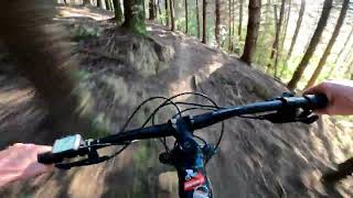
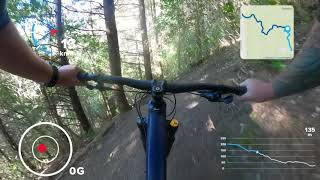
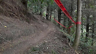
An off-camber, barely benched swooping fun trail. Naturaly extends either the top of Matai Face or Keyboard Warrior. Finishes on the Matai Valley road at the same spot as Loam Ranger and Maitai Face. Lead builders were Kurt, Liv, Hamish and Easy. New trail grade in 2021

Access Info

This trail is maintained by the Nelson Mountain Bike Club. Please consider supporting the club.

Recent Activity on Trail

Past Week
  • 4 rides
  • 12 miles average
6 Months
  • 34 rides
  • 13 miles avg distance
All
  • 144 rides
  • Last: Jun 14, 2026
c1c2c3c4
January
February
March
April
May
June
July
August
September
October
November
December
update trails status or condition

Mr Chomper Trail Reports

statusdatedescription
Jan 2, 2026 @ 6:05pm (Pacific/Auckland)
Jan 1, 2026
All clear
Dec 30, 2025 @ 8:27pm (Pacific/Auckland)
Dec 29, 2025
~5 trees down on the fire road on the way up. Cleared anything making it unrideable. Still lots of debris
Oct 10, 2025 @ 6:47pm (Pacific/Auckland)
Oct 9, 2025
reporter Open for recreational access
Jul 31, 2025 @ 11:17pm
Jul 31, 2025
reporter
Jul 28, 2025 @ 2:17pm
Jul 28, 2025
reporter TPFL Forests closed due to weather warning
more »
Status:
on Jan 2, 2026
Avg: 4.4 (14 votes)
Your vote: 0

view (2,325)
close
3D
Trail Conditions
  • Unknown
  • Snow Groomed
  • Snow Packed
  • Snow Covered
  • Snow Cover Partial
  • Freeze/thaw Cycle
  • Icy
  • Prevalent Mud
  • Wet
  • Variable
  • Ideal
  • Dry
  • Very Dry
Trail Flow (Ridden Direction)
Trailforks scans users ridelogs to determine the most popular direction each trail is ridden. A good flowing trail network will have most trails flowing in a single direction according to their intension.
The colour categories are based on what percentage of riders are riding a trail in its intended direction.
  • > 96%
  • > 90%
  • > 80%
  • > 70%
  • > 50%
  • < 50%
  • bi-directional trail
  • no data
Trail Last Ridden
Trailforks scans ridelogs to determine the last time a trail was ridden.
  • < 2 days
  • < 1 week
  • < 2 weeks
  • < 1 month
  • < 6 months
  • > 6 months
Trail Ridden Direction
The intended direction a trail should be ridden.
  • Downhill Only
  • Downhill Primary
  • Both Directions
  • Uphill Primary
  • Uphill Only
  • One Direction
Contribute Details
Colors indicate trail is missing specified detail.
  • Description
  • Photos
  • Description & Photos
  • Videos
Trail Popularity ?
Trailforks scans ridelogs to determine which trails are ridden the most in the last 9 months. Trails are compared with nearby trails in the same city region with a possible 25 colour shades. Think of this as a heatmap, more rides = more kinetic energy = warmer colors.
  • most popular
  • popular
  • less popular
  • not popular
ATV/ORV/OHV Filter
Max Vehicle Width
inches
US Cell Coverage
Legend
cell carrier legend

Radar Time
Activity Recordings
Trailforks uses anonymized public activity data. ?
Activity Recordings
Trailforks uses anonymized public activity data. ?
Personal Heatmap
Activity Types
all / none
Options
2
Date range month
Winter Trails
Warning A routing network for winter maps does not exist. Selecting trails using the winter trails layer has been disabled.
Missing Trails
Most Popular
Least Popular
Trails are colored based on popularity. The more popular a trail is, the more red. Less popular trails trend towards green.
Jump Magnitude Heatmap
Heatmap of where riders jump on trails. Zoom in to see individual jumps, click circles to view jump details.
BC Backroad Status

Service Road Atlas is a free to use, community-driven service for viewing and creating reports on the numerous back-country service roads around B.C. and Alberta.

map legend
Slope Aspect
Direction the slope faces
Flat N NE E SE S SW W NW
Trails Deemphasized
Trails are shown in grey.
disable
Only show trails with no bike usage.
Enable
Suggested Layers
Based on selected activity type

    Save the current map location and zoom level as your default home location whenever this page is loaded.

    Save
        Directions to mr-chomper trailhead (-41.282490, 173.334920)

        Photos

        7 more »
        27 |
        Dec 29, 2025 @ 11:27pm
        Dec 29, 2025
        30 |
        Dec 29, 2025 @ 11:27pm
        Dec 29, 2025
        19 |
        Dec 29, 2025 @ 11:27pm
        Dec 29, 2025
        20 |
        Dec 29, 2025 @ 11:27pm
        Dec 29, 2025

        Videos

        4 more »
        youtuber Mr Chomper@ Sharlands Forest. Nelson
        3:40 | 444 | Jul 29, 2022 , Nelson
        Trail preview and demo bike test: Mr Chomper...
        4:03 | 202 | Jul 7, 2022 , Nelson
        Mr Chomper, Sharlands, Nelson, New Zealand,...
        4:22 | 250 | Jun 13, 2022 , Nelson
        some loose Mr chompa for you
        0:00 | 532 | Dec 18, 2017 , Nelson

        Routes with this trail

        7 miles 1,528 ft 8
        Ride the trails in any order. Low key club racing
        12 miles 3,563 ft 8
        fun set of trails of a hard difficulty
        27 miles 7,814 ft 10 Race
        Mammoth Enduro Race Route for 2020 - 8 Stages 2 uplift. - Uplifted segments -Fringed Hill from Groom Creek...

        1 Review & Comments


        We hope you've been enjoying Trailforks!

        Create a FREE account to view trail comments and much more.

        • By NMTBCTF Pro NMTBC & contributors
        • #76415 - 7,381 views

        Frequently Asked Questions About Mr Chomper

        Where is Mr Chomper located?
        Mr Chomper is located in Waitarake/Sharlands, Nelson, New Zealand. It is part of the Waitarake/Sharlands trail network. The trailhead is located at coordinates -41.28249, 173.33492.
        How hard is Mr Chomper?
        Mr Chomper is rated as Black Diamond difficulty. The physical rating is Moderate. The average grade is 14.7%.
        What is the elevation gain for Mr Chomper?
        Mr Chomper has 3 m of elevation gain. The trail has 139 m of elevation descent. The elevation ranges from 57 m to 193 m.
        How long is Mr Chomper?
        Mr Chomper is 926.0 m long. The trail type is singletrack.

        Hit the Trail

        Open in App

        Get this trail on your phone instantly.
        open trail in app

        Download Trail

        Save to wishlist, Garmin & download.
        save the trail

        Find Related Routes

        Find routes and users activities that include this trail.
        find routes for this trail

        You must enter a description before submitting.