more stats
2,972 ft
Distance
-759 ft
Descent
00:05:14
Avg time
-759 ft
Altitude change
887 ft
Altitude min
1,646 ft
Altitude max
1,646 ft
Altitude start
886 ft
Altitude end
-25.5%
Grade
-57.9%
Grade max
-1.6%
Grade min
2,972 ft
Distance down
00:05:14
Avg time

Mr.T (lower) Details

  • Activities
    • Mountain Bike
    • E-Bike
  • Riding Area
    Mount Prevost
    Duncan, British Columbia
  • Difficulty Rating
  • Local Popularity
    75 in Mountain Biking [+]
    • 55 in E-Biking
  • Global Ranking
    #75811 in Mountain Biking [+]
    • #78252 in E-Biking
  • Trail Type
    Singletrack
  • Bike Type
    DH, AM
  • Direction
    Downhill Only
    Popular Direction Shown
  • Physical Rating
    Hard
  • Trail Visibility
    Always easy to follow
  • Dogs Allowed
    Yes
  • eBike Allowed
  • TTFs on Trail
    Bridge, Drop, Jump, Gap Jump
  • Land Owner
    Municipality of North Cowichan

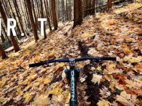
Mr.T is the go-to trail for racers looking to train. Riders can expect fast single track into tight turns with long steep descents along with some airtime to round things out.

Watch for a significant road gap off a well made ramp.

Local Trail Association
Traditionally Indigenous Territory

Recent Activity on Trail

Past Week
  • 0 rides
  •  
6 Months
  • 15 rides
  • 7 miles avg distance
All
  • 103 rides
  • Last: Jun 14, 2026
c1c2c3c4
January
February
March
April
May
June
July
August
September
October
November
December
update trails status or condition

Mr.T (lower) Trail Reports

statusdatedescription
Oct 15, 2024 @ 8:40pm
Oct 15, 2024
G2G
Oct 15, 2024 @ 8:31pm
Oct 15, 2024
G2G
May 5, 2024 @ 11:21am
May 5, 2024
Sep 18, 2022 @ 3:19pm
Sep 18, 2022
All good
Mar 14, 2022 @ 9:07am
Mar 14, 2022
reporter Considerable updates and rebuilds in the last few months by the CTSS. Watch for more upcoming CTSS trail days and our trail crew at work on...
more »
Status:
on Oct 15, 2024
Variable
Avg: 4.52 (11 votes)
Your vote: 0

view (689)
close
3D
Trail Conditions
  • Unknown
  • Snow Groomed
  • Snow Packed
  • Snow Covered
  • Snow Cover Partial
  • Freeze/thaw Cycle
  • Icy
  • Prevalent Mud
  • Wet
  • Variable
  • Ideal
  • Dry
  • Very Dry
Trail Flow (Ridden Direction)
Trailforks scans users ridelogs to determine the most popular direction each trail is ridden. A good flowing trail network will have most trails flowing in a single direction according to their intension.
The colour categories are based on what percentage of riders are riding a trail in its intended direction.
  • > 96%
  • > 90%
  • > 80%
  • > 70%
  • > 50%
  • < 50%
  • bi-directional trail
  • no data
Trail Last Ridden
Trailforks scans ridelogs to determine the last time a trail was ridden.
  • < 2 days
  • < 1 week
  • < 2 weeks
  • < 1 month
  • < 6 months
  • > 6 months
Trail Ridden Direction
The intended direction a trail should be ridden.
  • Downhill Only
  • Downhill Primary
  • Both Directions
  • Uphill Primary
  • Uphill Only
  • One Direction
Contribute Details
Colors indicate trail is missing specified detail.
  • Description
  • Photos
  • Description & Photos
  • Videos
Trail Popularity ?
Trailforks scans ridelogs to determine which trails are ridden the most in the last 9 months. Trails are compared with nearby trails in the same city region with a possible 25 colour shades. Think of this as a heatmap, more rides = more kinetic energy = warmer colors.
  • most popular
  • popular
  • less popular
  • not popular
ATV/ORV/OHV Filter
Max Vehicle Width
inches
US Cell Coverage
Legend
cell carrier legend

Radar Time
Activity Recordings
Trailforks uses anonymized public activity data. ?
Activity Recordings
Trailforks uses anonymized public activity data. ?
Personal Heatmap
Activity Types
all / none
Options
2
Date range month
Winter Trails
Warning A routing network for winter maps does not exist. Selecting trails using the winter trails layer has been disabled.
Missing Trails
Most Popular
Least Popular
Trails are colored based on popularity. The more popular a trail is, the more red. Less popular trails trend towards green.
Jump Magnitude Heatmap
Heatmap of where riders jump on trails. Zoom in to see individual jumps, click circles to view jump details.
BC Backroad Status

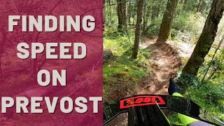
Service Road Atlas is a free to use, community-driven service for viewing and creating reports on the numerous back-country service roads around B.C. and Alberta.

map legend
Slope Aspect
Direction the slope faces
Flat N NE E SE S SW W NW
Trails Deemphasized
Trails are shown in grey.
disable
Only show trails with no bike usage.
Enable
Suggested Layers
Based on selected activity type

    Save the current map location and zoom level as your default home location whenever this page is loaded.

    Save
        Directions to mr-t-lower trailhead (48.839120, -123.752830)

        Photos

        3 more »
        334 |
        Sep 25, 2019 @ 6:14am
        Sep 25, 2019
        1,471 |
        Jul 16, 2012 @ 11:57pm
        Jul 16, 2012
        138 |
        Mar 31, 2021 @ 9:01pm
        Mar 31, 2021

        Videos

        8 more »
        youtuber All Time Fall Time at Mount Prevost
        8:19 | 87 | Nov 5, 2025 , Duncan
        Mr T (lower)
        16:33 | 259 | Apr 22, 2024 , Duncan
        NOBL POV: Mount Prevost Mr. T | Dean Tennant
        4:38 | 613 | Jan 4, 2022 , Duncan
        KOM Hunting
        0:31 | 1095 | Nov 8, 2017 , Duncan

        Routes with this trail

        1 mile 3
        BCBR DH presented by Canyon
        16 miles 5,167 ft 5 Loop Race
        This is the full length course for the 2024 Mt. Prevost Enduro. This course will be raced by the Expert,...

        Reviews / Comments

        No reviews yet, be the first to write a review or ask a question.
        Use trail reports to comment on trail conditions.


        We hope you've been enjoying Trailforks!

        Create a FREE account to view trail comments and much more.

        • By highrocker1298TF Pro & contributors
        • #7162 - 5,642 views

        Frequently Asked Questions About Mr.T (lower)

        Where is Mr.T (lower) located?
        Mr.T (lower) is located in Mount Prevost, Duncan, British Columbia, Canada. It is part of the Mount Prevost trail network. The trailhead is located at coordinates 48.83912, -123.75283.
        How hard is Mr.T (lower)?
        Mr.T (lower) is rated as Double Black Diamond difficulty. The physical rating is Hard. The average grade is 25.5%.
        What is the elevation gain for Mr.T (lower)?
        The trail has 231 m of elevation descent. The elevation ranges from 270 m to 502 m.
        Is Mr.T (lower) a point to point trail?
        Yes, Mr.T (lower) is a point to point trail. The direction is Downhill Only. The trail type is singletrack.

        Hit the Trail

        Open in App

        Get this trail on your phone instantly.
        open trail in app

        Download Trail

        Save to wishlist, Garmin & download.
        save the trail

        Find Related Routes

        Find routes and users activities that include this trail.
        find routes for this trail

        You must enter a description before submitting.