more stats
2.3 miles
Distance
226 ft
Climb
-1,444 ft
Descent
00:14:37
Avg time
-1,218 ft
Altitude change
477 ft
Altitude min
1,697 ft
Altitude max
1,697 ft
Altitude start
479 ft
Altitude end
-51.283%
Grade max
26.012%
Grade min
2,656 ft
Distance climb
2 miles
Distance down
220 ft
Distance flat
00:14:37
Avg time

Mt Dick Details

  • Activities
    • Mountain Bike
    • Gravel Bike
    • Adaptive Bike
    • Hike
    • Trail Running
  • Riding Area
  • Difficulty Rating
  • Local Popularity
    75 in Mountain Biking [+]
    • 5 in Trail Running
    • 5 in Hiking
  • Trail Type
    Dirt/Gravel Road
  • Bike Type
    AM, XC, Gravel, Adaptive MTB
  • Direction
    Both Directions
  • Climb Difficulty
    Blue
  • Physical Rating
    Moderate
  • Dogs Allowed
    Yes
  • Ride in Rain
    Yes

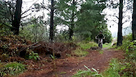
Steady climb that'll take about 40 mins. Blast back down in about 15 mins. At the top head down the 30m walking track to the lookout shelter where you can see prominent locations across the Wairarapa and Tararua Range.

Keep an eye out for 4WD's.

Local Trail Association

Recent Activity on Trail

Past Week
  • 0 rides
  •  
6 Months
  • 0 rides
  •  
All
  • 18 rides
  • Last: Feb 8, 2026
c1c2c3c4
January
February
March
April
May
June
July
August
September
October
November
December
update trails status or condition

Mt Dick Trail Reports

statusdatedescription
Apr 20, 2025 @ 3:23pm
Apr 20, 2025
Gravel track good condition
Jul 25, 2024 @ 12:41am
Jul 25, 2024
4WD track up in good condition.
Jun 29, 2024 @ 5:16am
Jun 29, 2024
Minor patches of gravel to ride over. Otherwise will packed
Jun 4, 2023 @ 3:32am
Jun 4, 2023
Mostly runs smooth with well packed gravel. Minor rutting/scour, and occasional loose gravel.
May 16, 2022 @ 10:28pm
May 16, 2022
Recently being graded so build up of loose gravel in places. A bit tougher than normal but a nice ride up there in the evening.
more »
Status:
on Apr 20, 2025
Ideal
Avg: 3.56 (1 votes)
Your vote: 0

view (290)
close
3D
Trail Conditions
  • Unknown
  • Snow Groomed
  • Snow Packed
  • Snow Covered
  • Snow Cover Partial
  • Freeze/thaw Cycle
  • Icy
  • Prevalent Mud
  • Wet
  • Variable
  • Ideal
  • Dry
  • Very Dry
Trail Flow (Ridden Direction)
Trailforks scans users ridelogs to determine the most popular direction each trail is ridden. A good flowing trail network will have most trails flowing in a single direction according to their intension.
The colour categories are based on what percentage of riders are riding a trail in its intended direction.
  • > 96%
  • > 90%
  • > 80%
  • > 70%
  • > 50%
  • < 50%
  • bi-directional trail
  • no data
Trail Last Ridden
Trailforks scans ridelogs to determine the last time a trail was ridden.
  • < 2 days
  • < 1 week
  • < 2 weeks
  • < 1 month
  • < 6 months
  • > 6 months
Trail Ridden Direction
The intended direction a trail should be ridden.
  • Downhill Only
  • Downhill Primary
  • Both Directions
  • Uphill Primary
  • Uphill Only
  • One Direction
Contribute Details
Colors indicate trail is missing specified detail.
  • Description
  • Photos
  • Description & Photos
  • Videos
Trail Popularity ?
Trailforks scans ridelogs to determine which trails are ridden the most in the last 9 months. Trails are compared with nearby trails in the same city region with a possible 25 colour shades. Think of this as a heatmap, more rides = more kinetic energy = warmer colors.
  • most popular
  • popular
  • less popular
  • not popular
ATV/ORV/OHV Filter
Max Vehicle Width
inches
US Cell Coverage
Legend
cell carrier legend

Radar Time
Activity Recordings
Trailforks uses anonymized public activity data. ?
Activity Recordings
Trailforks uses anonymized public activity data. ?
Personal Heatmap
Activity Types
all / none
Options
2
Date range month
Winter Trails
Warning A routing network for winter maps does not exist. Selecting trails using the winter trails layer has been disabled.
Missing Trails
Most Popular
Least Popular
Trails are colored based on popularity. The more popular a trail is, the more red. Less popular trails trend towards green.
Jump Magnitude Heatmap
Heatmap of where riders jump on trails. Zoom in to see individual jumps, click circles to view jump details.
BC Backroad Status

Service Road Atlas is a free to use, community-driven service for viewing and creating reports on the numerous back-country service roads around B.C. and Alberta.

map legend
Slope Aspect
Direction the slope faces
Flat N NE E SE S SW W NW
Trails Deemphasized
Trails are shown in grey.
disable
Only show trails with no bike usage.
Enable
Suggested Layers
Based on selected activity type

    Save the current map location and zoom level as your default home location whenever this page is loaded.

    Save
        Directions to mt-dick trailhead (-41.006510, 175.435560)

        Photos

        9 more »
        57 |
        Oct 8, 2019 @ 5:59pm
        Oct 8, 2019
        51 |
        Oct 8, 2019 @ 5:58pm
        Oct 8, 2019
        49 |
        Oct 8, 2019 @ 5:58pm
        Oct 8, 2019
        54 |
        Oct 8, 2019 @ 5:58pm
        Oct 8, 2019

        Videos

        1 more »
        Elkannah
        0:21 | 333 | Jun 22, 2020 , Carterton

        1 Review & Comments


        We hope you've been enjoying Trailforks!

        Create a FREE account to view trail comments and much more.

        • By YogiNZ & contributors
        • #27435 - 7,369 views

        Frequently Asked Questions About Mt Dick

        Where is Mt Dick located?
        Mt Dick is located in Carterton Mountain Bike Park, Carterton, New Zealand. It is part of the Carterton Mountain Bike Park trail network. The trailhead is located at coordinates -41.00651, 175.43556.
        What is the elevation gain for Mt Dick?
        Mt Dick has 69 m of elevation gain. The trail has 440 m of elevation descent. The elevation ranges from 145 m to 517 m.
        Is Mt Dick a point to point trail?
        Mt Dick is not a point to point trail. The direction is Both Directions. The trail type is dirt/gravel road.
        How long is Mt Dick?
        Mt Dick is 3.7 km long. The trail type is dirt/gravel road.

        Hit the Trail

        Open in App

        Get this trail on your phone instantly.
        open trail in app

        Download Trail

        Save to wishlist, Garmin & download.
        save the trail

        Find Related Routes

        Find routes and users activities that include this trail.
        find routes for this trail

        You must enter a description before submitting.