more stats
4.5 miles
Distance
58 ft
Climb
-1,476 ft
Descent
00:24:04
Avg time
-1,418 ft
Altitude change
5,568 ft
Altitude min
6,986 ft
Altitude max
6,986 ft
Altitude start
5,568 ft
Altitude end
-5.9%
Grade
-35.8%
Grade max
11.3%
Grade min
1,923 ft
Distance climb
4 miles
Distance down
1,424 ft
Distance flat
00:24:04
Avg time

Trail Details

  • Activities
    • Mountain Bike
    • E-Bike
    • Horse
    • Hike
    • Trail Running
    • Dirtbike/Moto
  • Riding Area
    Mt. Hough
    Quincy, California
  • Difficulty Rating
  • Voted Difficulty
    Blue (1 vote)
  • Local Popularity
    100 in Mountain Biking [+]
    • 100 in E-Biking
    • 5 in Trail Running
    • 100 in Hiking
    • 80 in Dirtbiking
    • 5 in Horseback
  • Global Ranking
    #35273 in Mountain Biking [+]
    • #2780 in E-Biking
    • #129601 in Trail Running
    • #630 in Hiking
    • #793 in Dirtbiking
    • #1041 in Horseback
  • Trail Type
    Singletrack
  • Bike Type
    AM, XC
  • Direction
    Downhill Primary
    Popular Direction Shown
  • Climb Difficulty
    Blue
  • Physical Rating
    Moderate
  • Trail Visibility
    Always easy to follow
  • Dogs Allowed
    Yes
  • eBike Allowed
    Yes up to Class 1
  • Land Owner
    Plumas National Forest

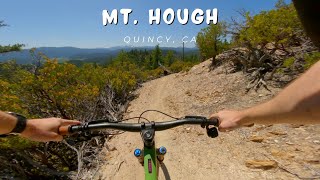
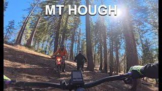
A ripping section of downhill, that can be fun on almost any bike. Starts with some steep but well built switchbacks, transitions into some flowy sidehill amidst wildfire burn, and finishes with a supreme section of banks and rollers. Can also be ridden uphill, and is a moto legal trail. Please yield to uphill traffic.

Trail Supporters

  • USFS
    Land Manager
Local Trail Association
Traditionally Indigenous Territory

Recent Activity on Trail

Past Week
  • 9 rides
  • 19 miles average
6 Months
  • 51 rides
  • 19 miles avg distance
All
  • 626 rides
  • Last: Jun 26, 2026
c1c2c3c4
January
February
March
April
May
June
July
August
September
October
November
December
update trails status or condition

Mt. Hough Summit... Trail Reports

statusdatedescription
May 30, 2026 @ 9:03am (America/Los_Angeles)
May 30, 2026
May 29, 2026 @ 8:35am (America/Los_Angeles)
May 29, 2026
reporter
May 1, 2026 @ 12:48pm (America/Los_Angeles)
May 1, 2026
reporter
May 1, 2026 @ 8:57am (America/Los_Angeles)
May 1, 2026
Mt Hough from the summit all the way down was amazing. No mud or damage or any wet spots the entire way down. Can just rip at full speed. There is...
Apr 19, 2026 @ 6:19pm (America/Los_Angeles)
Apr 19, 2026
Totally good to go. No down trees, minimal wet areas.
more »
Status:
on May 30, 2026
Avg: 4.21 (16 votes)
Your vote: 0

view (3,434)
close
3D
Trail Conditions
  • Unknown
  • Snow Groomed
  • Snow Packed
  • Snow Covered
  • Snow Cover Partial
  • Freeze/thaw Cycle
  • Icy
  • Prevalent Mud
  • Wet
  • Variable
  • Ideal
  • Dry
  • Very Dry
Trail Flow (Ridden Direction)
Trailforks scans users ridelogs to determine the most popular direction each trail is ridden. A good flowing trail network will have most trails flowing in a single direction according to their intension.
The colour categories are based on what percentage of riders are riding a trail in its intended direction.
  • > 96%
  • > 90%
  • > 80%
  • > 70%
  • > 50%
  • < 50%
  • bi-directional trail
  • no data
Trail Last Ridden
Trailforks scans ridelogs to determine the last time a trail was ridden.
  • < 2 days
  • < 1 week
  • < 2 weeks
  • < 1 month
  • < 6 months
  • > 6 months
Trail Ridden Direction
The intended direction a trail should be ridden.
  • Downhill Only
  • Downhill Primary
  • Both Directions
  • Uphill Primary
  • Uphill Only
  • One Direction
Contribute Details
Colors indicate trail is missing specified detail.
  • Description
  • Photos
  • Description & Photos
  • Videos
Trail Popularity ?
Trailforks scans ridelogs to determine which trails are ridden the most in the last 9 months. Trails are compared with nearby trails in the same city region with a possible 25 colour shades. Think of this as a heatmap, more rides = more kinetic energy = warmer colors.
  • most popular
  • popular
  • less popular
  • not popular
ATV/ORV/OHV Filter
Max Vehicle Width
inches
US Cell Coverage
Legend
cell carrier legend

Radar Time
Activity Recordings
Trailforks uses anonymized public activity data. ?
Activity Recordings
Trailforks uses anonymized public activity data. ?
Personal Heatmap
Activity Types
all / none
Options
2
Date range month
Winter Trails
Warning A routing network for winter maps does not exist. Selecting trails using the winter trails layer has been disabled.
Missing Trails
Most Popular
Least Popular
Trails are colored based on popularity. The more popular a trail is, the more red. Less popular trails trend towards green.
Jump Magnitude Heatmap
Heatmap of where riders jump on trails. Zoom in to see individual jumps, click circles to view jump details.
BC Backroad Status

Service Road Atlas is a free to use, community-driven service for viewing and creating reports on the numerous back-country service roads around B.C. and Alberta.

map legend
Slope Aspect
Direction the slope faces
Flat N NE E SE S SW W NW
Trails Deemphasized
Trails are shown in grey.
disable
Only show trails with no bike usage.
Enable
Suggested Layers
Based on selected activity type

    Save the current map location and zoom level as your default home location whenever this page is loaded.

    Save
        Directions to mt-hough-summit-to-rhinehart-meadow trailhead (40.048870, -120.888800)

        Photos

        12 more »
        94 |
        Sep 22, 2025 @ 6:27pm
        Sep 22, 2025
        79 |
        Sep 22, 2025 @ 6:26pm
        Sep 22, 2025
        149 |
        Sep 27, 2023 @ 9:33am
        Sep 27, 2023
        160 |
        Aug 28, 2023 @ 4:57pm
        Aug 28, 2023

        Videos

        7 more »
        youtuber Mt. Hough / Quincy, CA / MTB
        19:23 | 204 | May 23, 2024 , Quincy
        youtuber Mount Hough 2018 (Quincy, CA) Mountain Biking
        11:48 | 1078 | Oct 27, 2018 , Quincy
        youtuber Bell Super 3R DH Mips - Mt Hough - Quincy, Ca...
        16:22 | 638 | Nov 1, 2018 , Quincy
        Mt Hough loooooong #mtb descent!
        30:39 | 92 | Nov 3, 2024 , Quincy

        Routes with this trail

        5.0 15 miles 501 ft 7 Shuttled
        via King's Crossing trail is a good middle distance shuttle lap on the mountain. This alignment has a bit...
        5.0 28 miles 4,344 ft 11 Loop
        Just about he biggest, hardest most singletrack loop on the mountain. This loop is legal both directions...
        4.0 10 miles 170 ft 13 Loop
        This trail is must for those who like fast, flowy downhill with sweeping berms, features, and majestic...

        6 Reviews & Comments


        We hope you've been enjoying Trailforks!

        Create a FREE account to view trail comments and much more.

        • By canadakaTF Pro Trailforks & contributors
        • #55914 - 7,719 views

        Frequently Asked Questions About Mt. Hough Summit to Rhinehart Meadow

        Where is Mt. Hough Summit to Rhinehart Meadow located?
        Mt. Hough Summit to Rhinehart Meadow is located in Mt. Hough, Quincy, California, United States. It is part of the Mt. Hough trail network. The trailhead is located at coordinates 40.04887, -120.8888.
        How hard is Mt. Hough Summit to Rhinehart Meadow?
        Mt. Hough Summit to Rhinehart Meadow is rated as Blue difficulty. The physical rating is Moderate. The average grade is 5.9%. The climb difficulty is rated Blue.
        What is the elevation gain for Mt. Hough Summit to Rhinehart Meadow?
        Mt. Hough Summit to Rhinehart Meadow has 58 ft of elevation gain. The trail has 1,476 ft of elevation descent. The elevation ranges from 5,568 ft to 6,986 ft.
        Is Mt. Hough Summit to Rhinehart Meadow a point to point trail?
        Mt. Hough Summit to Rhinehart Meadow is not a point to point trail. The direction is Downhill Primary. The trail type is singletrack.

        Hit the Trail

        Open in App

        Get this trail on your phone instantly.
        open trail in app

        Download Trail

        Save to wishlist, Garmin & download.
        save the trail

        Find Related Routes

        Find routes and users activities that include this trail.
        find routes for this trail

        You must enter a description before submitting.