more stats
1.1 miles
Distance
199 ft
Climb
-191 ft
Descent
00:20:28
Avg time
9 ft
Altitude change
920 ft
Altitude min
1,101 ft
Altitude max
920 ft
Altitude start
928 ft
Altitude end
0.1%
Grade
-34.5%
Grade max
26.3%
Grade min
2,510 ft
Distance climb
2,762 ft
Distance down
755 ft
Distance flat
00:20:28
Avg time

Munsee Eagle Details

  • Activities
    • Mountain Bike
    • Hike
    • Trail Running
  • Riding Area
    Sterling Forest State Park
    Tuxedo, New York
  • AKA
    Palisades 18
  • Difficulty Rating
  • Local Popularity
    75 in Mountain Biking [+]
    • 95 in Trail Running
    • 80 in Hiking
  • Global Ranking
    #25601 in Mountain Biking [+]
    • #25812 in Trail Running
    • #64755 in Hiking
  • Trail Type
    Singletrack
  • Bike Type
    AM, XC
  • Direction
    Both Directions
  • Climb Difficulty
    Blue
  • Physical Rating
    Moderate
  • Trail Visibility
    Always easy to follow
  • Season
    All but freeze thaw, and heavy rains
  • Dogs Allowed
    Yes
  • eBike Allowed
  • TTFs on Trail
    Berm, Drop, Jump, Rock Face, Rock Garden, Roller Coaster, Other
  • Year Opened
    2018
  • Land Owner

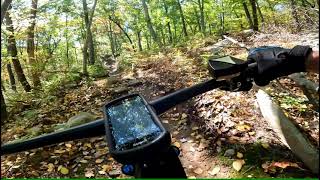
This section of the Munsee-Eagle trail was built in 2018 by the Trail Conference Conservation Corps and volunteers. From either end the description is similar. It ascends about .4 of a mile to reach its summit where it crosses under the power lines. At the power lines turn to the left and follow the road for about 100 feet before turning right. The trail then descend down to the fire road for a short ride to the other sections of the ME trail.

Trail Supporters
Local Trail Association
Traditionally Indigenous Territory

Recent Activity on Trail

Past Week
  • 11 rides
  • 12 miles average
6 Months
  • 126 rides
  • 12 miles avg distance
All
  • 2,072 rides
  • Last: Jun 19, 2026
c1c2c3c4
January
February
March
April
May
June
July
August
September
October
November
December
Status:
on Jun 19, 2026
Avg: 4.29 (5 votes)
Your vote: 0

view (8,833)
close
3D
Trail Conditions
  • Unknown
  • Snow Groomed
  • Snow Packed
  • Snow Covered
  • Snow Cover Partial
  • Freeze/thaw Cycle
  • Icy
  • Prevalent Mud
  • Wet
  • Variable
  • Ideal
  • Dry
  • Very Dry
Trail Flow (Ridden Direction)
Trailforks scans users ridelogs to determine the most popular direction each trail is ridden. A good flowing trail network will have most trails flowing in a single direction according to their intension.
The colour categories are based on what percentage of riders are riding a trail in its intended direction.
  • > 96%
  • > 90%
  • > 80%
  • > 70%
  • > 50%
  • < 50%
  • bi-directional trail
  • no data
Trail Last Ridden
Trailforks scans ridelogs to determine the last time a trail was ridden.
  • < 2 days
  • < 1 week
  • < 2 weeks
  • < 1 month
  • < 6 months
  • > 6 months
Trail Ridden Direction
The intended direction a trail should be ridden.
  • Downhill Only
  • Downhill Primary
  • Both Directions
  • Uphill Primary
  • Uphill Only
  • One Direction
Contribute Details
Colors indicate trail is missing specified detail.
  • Description
  • Photos
  • Description & Photos
  • Videos
Trail Popularity ?
Trailforks scans ridelogs to determine which trails are ridden the most in the last 9 months. Trails are compared with nearby trails in the same city region with a possible 25 colour shades. Think of this as a heatmap, more rides = more kinetic energy = warmer colors.
  • most popular
  • popular
  • less popular
  • not popular
ATV/ORV/OHV Filter
Max Vehicle Width
inches
US Cell Coverage
Legend
cell carrier legend

Radar Time
Activity Recordings
Trailforks uses anonymized public activity data. ?
Activity Recordings
Trailforks uses anonymized public activity data. ?
Personal Heatmap
Activity Types
all / none
Options
2
Date range month
Winter Trails
Warning A routing network for winter maps does not exist. Selecting trails using the winter trails layer has been disabled.
Missing Trails
Most Popular
Least Popular
Trails are colored based on popularity. The more popular a trail is, the more red. Less popular trails trend towards green.
Jump Magnitude Heatmap
Heatmap of where riders jump on trails. Zoom in to see individual jumps, click circles to view jump details.
BC Backroad Status

Service Road Atlas is a free to use, community-driven service for viewing and creating reports on the numerous back-country service roads around B.C. and Alberta.

map legend
Slope Aspect
Direction the slope faces
Flat N NE E SE S SW W NW
Trails Deemphasized
Trails are shown in grey.
disable
Only show trails with no bike usage.
Enable
Suggested Layers
Based on selected activity type

    Save the current map location and zoom level as your default home location whenever this page is loaded.

    Save
        Directions to munsee-eagle trailhead (41.189830, -74.228380)

        Photos

        31 more »
        22 |
        May 2, 2026 @ 8:02am
        May 2, 2026
        20 |
        May 2, 2026 @ 8:02am
        May 2, 2026
        80 |
        Sep 28, 2023 @ 4:30am
        Sep 28, 2023
        120 |
        Sep 28, 2023 @ 4:30am
        Sep 28, 2023

        Videos

        2 more »
        Sterling Forest Mountain Biking Oct 14, 2021
        41:54 | 262 | Oct 16, 2021 , Tuxedo
        Roller Heaven
        0:31 | 244 | Jan 24, 2023 , Tuxedo

        Routes with this trail

        5.0 7 miles 942 ft 10 Loop
        Route from s parking lot, rides well in both directions.
        17 miles 1,862 ft 4 Loop
        Connecting Sterling loop with Ringwood. Warmup in Ringwood. Restock at parking and ride to Sterling.
        11 miles 1,946 ft 3 Loop
        Take the normal Hutchinson loop but cut out the flowy, 2-mile downhill and exchange it for a lot of rocks...

        1 Review & Comments


        We hope you've been enjoying Trailforks!

        Create a FREE account to view trail comments and much more.

        Frequently Asked Questions About Munsee Eagle

        Where is Munsee Eagle located?
        Munsee Eagle is located in Sterling Forest State Park, Tuxedo, New York, United States. It is part of the Sterling Forest State Park trail network. The trailhead is located at coordinates 41.18983, -74.22838.
        How hard is Munsee Eagle?
        Munsee Eagle is rated as Black Diamond difficulty. The physical rating is Moderate. The average grade is 0.1%. The climb difficulty is rated Blue.
        What is the elevation gain for Munsee Eagle?
        Munsee Eagle has 199 ft of elevation gain. The trail has 191 ft of elevation descent. The elevation ranges from 920 ft to 1,101 ft.
        Is Munsee Eagle a point to point trail?
        Munsee Eagle is not a point to point trail. The direction is Both Directions. The trail type is singletrack.

        Hit the Trail

        Open in App

        Get this trail on your phone instantly.
        open trail in app

        Download Trail

        Save to wishlist, Garmin & download.
        save the trail

        Find Related Routes

        Find routes and users activities that include this trail.
        find routes for this trail

        You must enter a description before submitting.