more stats
1.1 miles
Distance
9 ft
Climb
-312 ft
Descent
00:04:55
Avg time
-303 ft
Altitude change
3,725 ft
Altitude min
4,028 ft
Altitude max
4,028 ft
Altitude start
3,724 ft
Altitude end
-5.3%
Grade
-18.2%
Grade max
6.3%
Grade min
427 ft
Distance climb
4,150 ft
Distance down
1,142 ft
Distance flat
00:04:55
Avg time

Muscle Hamster Details

  • Activities
    • Mountain Bike
    • E-Bike
  • Riding Area
    Winsport Bike Park
    Calgary, Alberta
  • Difficulty Rating
  • Voted Difficulty
    Green (1 vote)
  • Local Popularity
    70 in Mountain Biking [+]
    • 70 in E-Biking
  • Global Ranking
    #58996 in Mountain Biking
  • Trail Type
    Machine Groomed
  • Bike Type
    DH, AM, XC
  • Physical Rating
    Easy
  • Trail Visibility
    Always easy to follow
  • eBike Allowed
    Yes up to Class 1
  • TTFs on Trail
    Berm, Bridge, Jump
  • Ride in Rain
    Yes
  • Year Opened
    2020
  • Land Owner

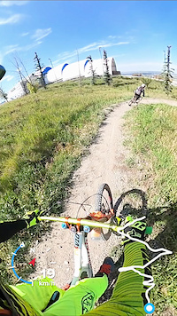
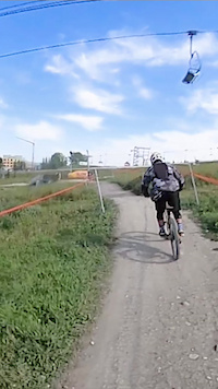
Machine Built Freeride Style Trail. Lots of berms and rollers. Optional blue trails are accessible from this trial. Great fun trail for skill development.

Access Info

Valid Ticket or Pass Required

Bike Park

Recent Activity on Trail

Past Week
  • 4 rides
  • 10 miles average
6 Months
  • 4 rides
  • 10 miles avg distance
All
  • 262 rides
  • Last: Jun 21, 2026
c1c2c3c4
January
February
March
April
May
June
July
August
September
October
November
December
update trails status or condition

Muscle Hamster Trail Reports

Status:
on Aug 4, 2024
Very Dry
Avg: 3.68 (7 votes)
Your vote: 0

view (3,505)
close
3D
Trail Conditions
  • Unknown
  • Snow Groomed
  • Snow Packed
  • Snow Covered
  • Snow Cover Partial
  • Freeze/thaw Cycle
  • Icy
  • Prevalent Mud
  • Wet
  • Variable
  • Ideal
  • Dry
  • Very Dry
Trail Flow (Ridden Direction)
Trailforks scans users ridelogs to determine the most popular direction each trail is ridden. A good flowing trail network will have most trails flowing in a single direction according to their intension.
The colour categories are based on what percentage of riders are riding a trail in its intended direction.
  • > 96%
  • > 90%
  • > 80%
  • > 70%
  • > 50%
  • < 50%
  • bi-directional trail
  • no data
Trail Last Ridden
Trailforks scans ridelogs to determine the last time a trail was ridden.
  • < 2 days
  • < 1 week
  • < 2 weeks
  • < 1 month
  • < 6 months
  • > 6 months
Trail Ridden Direction
The intended direction a trail should be ridden.
  • Downhill Only
  • Downhill Primary
  • Both Directions
  • Uphill Primary
  • Uphill Only
  • One Direction
Contribute Details
Colors indicate trail is missing specified detail.
  • Description
  • Photos
  • Description & Photos
  • Videos
Trail Popularity ?
Trailforks scans ridelogs to determine which trails are ridden the most in the last 9 months. Trails are compared with nearby trails in the same city region with a possible 25 colour shades. Think of this as a heatmap, more rides = more kinetic energy = warmer colors.
  • most popular
  • popular
  • less popular
  • not popular
ATV/ORV/OHV Filter
Max Vehicle Width
inches
US Cell Coverage
Legend
cell carrier legend

Radar Time
Activity Recordings
Trailforks uses anonymized public activity data. ?
Activity Recordings
Trailforks uses anonymized public activity data. ?
Personal Heatmap
Activity Types
all / none
Options
2
Date range month
Winter Trails
Warning A routing network for winter maps does not exist. Selecting trails using the winter trails layer has been disabled.
Missing Trails
Most Popular
Least Popular
Trails are colored based on popularity. The more popular a trail is, the more red. Less popular trails trend towards green.
Jump Magnitude Heatmap
Heatmap of where riders jump on trails. Zoom in to see individual jumps, click circles to view jump details.
BC Backroad Status

Service Road Atlas is a free to use, community-driven service for viewing and creating reports on the numerous back-country service roads around B.C. and Alberta.

map legend
Slope Aspect
Direction the slope faces
Flat N NE E SE S SW W NW
Trails Deemphasized
Trails are shown in grey.
disable
Only show trails with no bike usage.
Enable
Suggested Layers
Based on selected activity type

    Save the current map location and zoom level as your default home location whenever this page is loaded.

    Save
        Directions to muscle-hamster trailhead (51.076630, -114.220090)

        Photos

        3 more »
        212 |
        Aug 5, 2019 @ 4:30pm
        Aug 5, 2019
        430 |
        Sep 17, 2012 @ 5:13pm
        Sep 17, 2012
        829 |
        Sep 27, 2012 @ 1:40pm
        Sep 27, 2012

        Videos

        5 more »
        Muscle Hamster (COP)
        3:40 | 455 | Jul 28, 2022 , Calgary
        Canada Olympic bike park
        12:24 | 623 | Apr 28, 2019 , Calgary
        Reyrvn in front at Winsport
        2:35 | 53 | Sep 8, 2023 , Calgary
        Reyrvn is sending it!
        0:44 | 23 | Sep 4, 2023 , Calgary

        3 Reviews & Comments


        We hope you've been enjoying Trailforks!

        Create a FREE account to view trail comments and much more.

        • By Neilr01 & contributors
        • #24389 - 3,950 views

        Frequently Asked Questions About Muscle Hamster

        Where is Muscle Hamster located?
        Muscle Hamster is located in Winsport Bike Park, Calgary, Alberta, Canada. It is part of the Winsport Bike Park trail network. The trailhead is located at coordinates 51.07663, -114.22009.
        How hard is Muscle Hamster?
        Muscle Hamster is rated as Green difficulty. The physical rating is Easy. The average grade is 5.3%.
        What is the elevation gain for Muscle Hamster?
        Muscle Hamster has 9 ft of elevation gain. The trail has 312 ft of elevation descent. The elevation ranges from 3,725 ft to 4,028 ft.
        How long is Muscle Hamster?
        Muscle Hamster is 1.1 miles long. The trail type is machine groomed.

        Hit the Trail

        Open in App

        Get this trail on your phone instantly.
        open trail in app

        Download Trail

        Save to wishlist, Garmin & download.
        save the trail

        Find Related Routes

        Find routes and users activities that include this trail.
        find routes for this trail

        You must enter a description before submitting.