more stats
3,274 ft
Distance
4 ft
Climb
-332 ft
Descent
00:07:13
Avg time
-330 ft
Altitude change
1,407 ft
Altitude min
1,741 ft
Altitude max
1,738 ft
Altitude start
1,407 ft
Altitude end
-10.1%
Grade
-24.9%
Grade max
3.3%
Grade min
272 ft
Distance climb
2,897 ft
Distance down
108 ft
Distance flat
00:07:13
Avg time

Mushroom Trail Details

  • Activities
    • Mountain Bike
    • E-Bike
    • Gravel Bike
    • Hike
    • Trail Running
  • Riding Area
    Mount Seymour
    North Vancouver, British Columbia
  • Difficulty Rating
  • Voted Difficulty
    Blue (3 votes)
  • Local Popularity
    90 in Mountain Biking [+]
    • 90 in E-Biking
    • 60 in Trail Running
    • 60 in Hiking
  • Global Ranking
    #49256 in Mountain Biking [+]
    • #23464 in E-Biking
    • #105834 in Trail Running
    • #96846 in Hiking
  • Trail Type
    Doubletrack
  • Bike Type
    DH, AM, XC, Gravel
  • Direction
    Both Directions
    Popular In Reverse
  • Climb Difficulty
    Green
  • Physical Rating
    Moderate
  • Dogs Allowed
    Yes
  • eBike Allowed
    Yes up to Class 1
  • Ride in Rain
    Yes
  • Land Owner
    LSCR

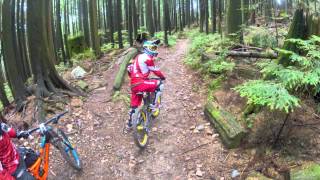
Mushroom Trail is a double-track, machine built trail. Although technically a multi-directional trail, Mushroom makes a lot of sense as a climbing trail. It is an excellent way to link Corkscrew, Salvation, Incline and Power Line without having to climb the road. A short hike-a-bike up incline from the top of Mushroom also allws access to TNT and the top of Corkscrew. If you do ride down Mushroom, please watch your speed. There are a few blind corners that can be dangerous for hikers and uphill riders.

Local Trail Association

Recent Activity on Trail

Past Week
  • 20 rides
  • 9 miles average
6 Months
  • 432 rides
  • 10 miles avg distance
All
  • 2,713 rides
  • Last: Jun 25, 2026
c1c2c3c4
January
February
March
April
May
June
July
August
September
October
November
December
Status:
on Jun 13, 2026
Ideal
Avg: 2.97 (24 votes)
Your vote: 0

view (17,182)
close
3D
Trail Conditions
  • Unknown
  • Snow Groomed
  • Snow Packed
  • Snow Covered
  • Snow Cover Partial
  • Freeze/thaw Cycle
  • Icy
  • Prevalent Mud
  • Wet
  • Variable
  • Ideal
  • Dry
  • Very Dry
Trail Flow (Ridden Direction)
Trailforks scans users ridelogs to determine the most popular direction each trail is ridden. A good flowing trail network will have most trails flowing in a single direction according to their intension.
The colour categories are based on what percentage of riders are riding a trail in its intended direction.
  • > 96%
  • > 90%
  • > 80%
  • > 70%
  • > 50%
  • < 50%
  • bi-directional trail
  • no data
Trail Last Ridden
Trailforks scans ridelogs to determine the last time a trail was ridden.
  • < 2 days
  • < 1 week
  • < 2 weeks
  • < 1 month
  • < 6 months
  • > 6 months
Trail Ridden Direction
The intended direction a trail should be ridden.
  • Downhill Only
  • Downhill Primary
  • Both Directions
  • Uphill Primary
  • Uphill Only
  • One Direction
Contribute Details
Colors indicate trail is missing specified detail.
  • Description
  • Photos
  • Description & Photos
  • Videos
Trail Popularity ?
Trailforks scans ridelogs to determine which trails are ridden the most in the last 9 months. Trails are compared with nearby trails in the same city region with a possible 25 colour shades. Think of this as a heatmap, more rides = more kinetic energy = warmer colors.
  • most popular
  • popular
  • less popular
  • not popular
ATV/ORV/OHV Filter
Max Vehicle Width
inches
US Cell Coverage
Legend
cell carrier legend

Radar Time
Activity Recordings
Trailforks uses anonymized public activity data. ?
Activity Recordings
Trailforks uses anonymized public activity data. ?
Personal Heatmap
Activity Types
all / none
Options
2
Date range month
Winter Trails
Warning A routing network for winter maps does not exist. Selecting trails using the winter trails layer has been disabled.
Missing Trails
Most Popular
Least Popular
Trails are colored based on popularity. The more popular a trail is, the more red. Less popular trails trend towards green.
Jump Magnitude Heatmap
Heatmap of where riders jump on trails. Zoom in to see individual jumps, click circles to view jump details.
BC Backroad Status

Service Road Atlas is a free to use, community-driven service for viewing and creating reports on the numerous back-country service roads around B.C. and Alberta.

map legend
Slope Aspect
Direction the slope faces
Flat N NE E SE S SW W NW
Trails Deemphasized
Trails are shown in grey.
disable
Only show trails with no bike usage.
Enable
Suggested Layers
Based on selected activity type

    Save the current map location and zoom level as your default home location whenever this page is loaded.

    Save
        Directions to mushroom-trail trailhead (49.341820, -122.973420)

        Photos

        25 more »
        382 |
        Oct 28, 2012 @ 3:28pm
        Oct 28, 2012
        174 |
        Jan 7, 2016 @ 10:46pm
        Jan 7, 2016
        213 |
        Jan 7, 2016 @ 10:43pm
        Jan 7, 2016
        336 |
        Jul 27, 2015 @ 3:45pm
        Jul 27, 2015

        Videos

        1 more »
        Vancouver Mount Seymour North Shore - Incline...
        1182 | Sep 14, 2016 , North Vancouver

        Trail Lists

        Routes with this trail

        2.0 11 miles 2,497 ft 24
        Good up loop with black diamond down and easy home.
        2.0 14 miles 3,453 ft 38 Loop
        A big Seymour lap looping multiple trails into figure 8's that allows you to make some substitutions if...
        18 miles 3,891 ft 52
        This is a route you can take to complete the double crown. It includes climbing and descending both...

        2 Reviews & Comments


        We hope you've been enjoying Trailforks!

        Create a FREE account to view trail comments and much more.

        • By canadakaTF Pro Trailforks & contributors
        • #2130 - 11,190 views

        Frequently Asked Questions About Mushroom Trail

        Where is Mushroom Trail located?
        Mushroom Trail is located in Mount Seymour, North Vancouver, British Columbia, Canada. It is part of the Mount Seymour trail network. The trailhead is located at coordinates 49.34182, -122.97342.
        How hard is Mushroom Trail?
        Mushroom Trail is rated as Green difficulty. The physical rating is Moderate. The average grade is 10.1%. The climb difficulty is rated Green.
        What is the elevation gain for Mushroom Trail?
        Mushroom Trail has 4 ft of elevation gain. The trail has 332 ft of elevation descent. The elevation ranges from 1,407 ft to 1,741 ft.
        Is Mushroom Trail a point to point trail?
        Mushroom Trail is not a point to point trail. The direction is Both Directions. The trail type is doubletrack.

        Hit the Trail

        Open in App

        Get this trail on your phone instantly.
        open trail in app

        Download Trail

        Save to wishlist, Garmin & download.
        save the trail

        Find Related Routes

        Find routes and users activities that include this trail.
        find routes for this trail

        You must enter a description before submitting.