



Open in App
Get this trail on your phone instantly.

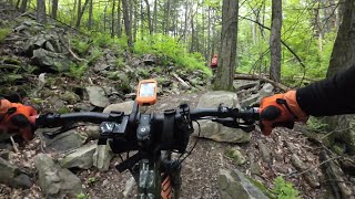
This starts at the parking area trailhead for Musser Gap, or you could ride there from downtown via the Musser Gap Greenway. It begins as a slow gentle climb on doubletrack before increasing in slope as the trail climbs. Once you cross the stream next to the two logs and bear left at the intersection with Frog Hollow Trail (no bikes allowed) the climbing begins in earnest. There is a very short steep section that takes you past where the old dam used to be before flattening out and you come to the intersection with Mountain Mist Trail. Bear left to follow Musser Gap Trail upto the second intersection with Mountain Mist Trail along the powerline. Musser Gap Trail does continue across Mountain Mist Trail, but at this point it is hiking only up to the Mid State Trail, also pretty much would be a hike-a-bike.

| c1 | c2 | c3 | c4 |
|---|---|---|---|
January | February | March | April |
May | June | July | August |
September | October | November | December |


Service Road Atlas is a free to use, community-driven service for viewing and creating reports on the numerous back-country service roads around B.C. and Alberta.
Save the current map location and zoom level as your default home location whenever this page is loaded.
Save
We hope you've been enjoying Trailforks!
Create a FREE account to view trail comments and much more.
 NMBA & contributors
You must enter a description before submitting.

