more stats
4.8 miles
Distance
1,412 ft
Climb
-1,394 ft
Descent
01:57:51
Avg time
18 ft
Altitude change
720 ft
Altitude min
2,042 ft
Altitude max
823 ft
Altitude start
840 ft
Altitude end
0.1%
Grade
-64.6%
Grade max
65%
Grade min
2 miles
Distance climb
2 miles
Distance down
2,077 ft
Distance flat
01:57:51
Avg time

Nan Bield Pass Details

  • Activities
    • Mountain Bike
    • Hike
    • Trail Running
  • Riding Area
    Staveley
    Kentmere
  • Difficulty Rating
  • Voted Difficulty
    Black (2 votes)
  • Local Popularity
    15 in Mountain Biking [+]
    • 5 in Trail Running
    • 5 in Hiking
  • Global Ranking
    #124864 in Mountain Biking [+]
    • #128216 in Trail Running
    • #121302 in Hiking
  • Trail Type
    Singletrack
  • Bike Type
    AM
  • Direction
    Both Directions
    Popular Direction Shown
  • Climb Difficulty
    Black Diamond
  • Physical Rating
    Hard
  • Dogs Allowed
    Yes
  • eBike Allowed
    Yes up to Class 1

From Mountain Bike Rider Magazine (3 Feb 2014)

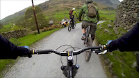
This ride is all about reaching the infamous Nan Bield Pass and experiencing the Kentmere Common descent that follows it.

Sunken alpine hairpins, fast stony singletrack, sketchy, mucky gambles, sudden techy chutes, chilling streams, nightmare ruts and some all-out randomness… all set amid an awesome Lakeland valley landscape.

But before you get to the fun wild stuff you’ve got a fair amount of leg and shoulder work to do. The Lake District ain’t no trail centre. You have to put in the grunts before you get to the stunts.

The relatively gentle warm-up along pastoral farm tracks heading away from Stile End acts as an ideal way of easing yourself into the day’s adventure. The speedy but straightforward descent down into Longsleddale is a nice awakening of the synapses but it’s in no way indicative of the descents that you’ll have to deal with later.

An almighty climb up the valley head takes you to the Gatescarth Pass, whereupon the descending switches up a gear with a speedway hurtle down into the amazing Haweswater valley. But the best is yet to come. And the worst.

The worst is dealt with first: getting up to Nan Bield Pass. The first third is rideable, the middle is a lovely contour around the stunning Small Water tarn, the final is a killer hike-a-bike up a trail resembling an insane rockery.

It’s hard work. But it’s well worth it. From Nan Bield Pass back down to Stile End will live long in the memory.


Read more at http://www.mbr.co.uk/routes/nan-bield-lake-district-gps-route-download-319992#V6IEmtMkPAXw3xwL.99

source: MBR
Local Trail Association

Recent Activity on Trail

Past Week
  • 0 rides
  •  
6 Months
  • 0 rides
  •  
All
  • 2 rides
  • Last: Mar 7, 2026
c1c2c3c4
January
February
March
April
May
June
July
August
September
October
November
December
update trails status or condition

Nan Bield Pass Trail Reports

Status:
on Oct 16, 2022
Wet
Avg: 3.62 (10 votes)
Your vote: 0

view (108)
close
3D
Trail Conditions
  • Unknown
  • Snow Groomed
  • Snow Packed
  • Snow Covered
  • Snow Cover Partial
  • Freeze/thaw Cycle
  • Icy
  • Prevalent Mud
  • Wet
  • Variable
  • Ideal
  • Dry
  • Very Dry
Trail Flow (Ridden Direction)
Trailforks scans users ridelogs to determine the most popular direction each trail is ridden. A good flowing trail network will have most trails flowing in a single direction according to their intension.
The colour categories are based on what percentage of riders are riding a trail in its intended direction.
  • > 96%
  • > 90%
  • > 80%
  • > 70%
  • > 50%
  • < 50%
  • bi-directional trail
  • no data
Trail Last Ridden
Trailforks scans ridelogs to determine the last time a trail was ridden.
  • < 2 days
  • < 1 week
  • < 2 weeks
  • < 1 month
  • < 6 months
  • > 6 months
Trail Ridden Direction
The intended direction a trail should be ridden.
  • Downhill Only
  • Downhill Primary
  • Both Directions
  • Uphill Primary
  • Uphill Only
  • One Direction
Contribute Details
Colors indicate trail is missing specified detail.
  • Description
  • Photos
  • Description & Photos
  • Videos
Trail Popularity ?
Trailforks scans ridelogs to determine which trails are ridden the most in the last 9 months. Trails are compared with nearby trails in the same city region with a possible 25 colour shades. Think of this as a heatmap, more rides = more kinetic energy = warmer colors.
  • most popular
  • popular
  • less popular
  • not popular
ATV/ORV/OHV Filter
Max Vehicle Width
inches
US Cell Coverage
Legend
cell carrier legend

Radar Time
Activity Recordings
Trailforks uses anonymized public activity data. ?
Activity Recordings
Trailforks uses anonymized public activity data. ?
Personal Heatmap
Activity Types
all / none
Options
2
Date range month
Winter Trails
Warning A routing network for winter maps does not exist. Selecting trails using the winter trails layer has been disabled.
Missing Trails
Most Popular
Least Popular
Trails are colored based on popularity. The more popular a trail is, the more red. Less popular trails trend towards green.
Jump Magnitude Heatmap
Heatmap of where riders jump on trails. Zoom in to see individual jumps, click circles to view jump details.
BC Backroad Status

Service Road Atlas is a free to use, community-driven service for viewing and creating reports on the numerous back-country service roads around B.C. and Alberta.

map legend
Slope Aspect
Direction the slope faces
Flat N NE E SE S SW W NW
Trails Deemphasized
Trails are shown in grey.
disable
Only show trails with no bike usage.
Enable
Suggested Layers
Based on selected activity type

    Save the current map location and zoom level as your default home location whenever this page is loaded.

    Save
        Directions to nan-bield-pass trailhead (54.489080, -2.820630)

        Photos

        20 more »
        146 |
        Mar 6, 2021 @ 12:20pm
        Mar 6, 2021
        480 |
        Jan 1, 2020 @ 6:32am
        Jan 1, 2020
        334 |
        Jan 1, 2020 @ 6:30am
        Jan 1, 2020
        232 |
        Aug 14, 2019 @ 4:34am
        Aug 14, 2019

        Videos

        2 more »
        Proper Preparation Prevents Poor Performance.
        4:38 | 265 | Nov 20, 2016 , Kentmere
        Nan Bield pass to Harter Fell
        8:44 | 936 | May 8, 2014 , Kentmere

        Routes with this trail

        5.0 25 miles 4,592 ft 2 Loop
        Very challenging MTB route

        3 Reviews & Comments


        We hope you've been enjoying Trailforks!

        Create a FREE account to view trail comments and much more.

        • By wilfgood & contributors
        • #54524 - 5,147 views

        Frequently Asked Questions About Nan Bield Pass

        Where is Nan Bield Pass located?
        Nan Bield Pass is located in Staveley, Kentmere, United Kingdom. It is part of the Staveley trail network. The trailhead is located at coordinates 54.48908, -2.82063.
        How hard is Nan Bield Pass?
        Nan Bield Pass is rated as Red difficulty. The physical rating is Hard. The average grade is 0.1%. The climb difficulty is rated Black Diamond.
        What is the elevation gain for Nan Bield Pass?
        Nan Bield Pass has 1,412 ft of elevation gain. The trail has 1,394 ft of elevation descent. The elevation ranges from 720 ft to 2,042 ft.
        Is Nan Bield Pass a point to point trail?
        Nan Bield Pass is not a point to point trail. The direction is Both Directions. The trail type is singletrack.

        Hit the Trail

        Open in App

        Get this trail on your phone instantly.
        open trail in app

        Download Trail

        Save to wishlist, Garmin & download.
        save the trail

        Find Related Routes

        Find routes and users activities that include this trail.
        find routes for this trail

        You must enter a description before submitting.