more stats
4,347 ft
Distance
-982 ft
Descent
00:07:22
Avg time
-982 ft
Altitude change
7,382 ft
Altitude min
8,364 ft
Altitude max
8,364 ft
Altitude start
7,382 ft
Altitude end
-22.6%
Grade
-62.9%
Grade max
-3.4%
Grade min
4,347 ft
Distance down
00:07:22
Avg time

NCS Details

  • Activities
    • Mountain Bike
  • Riding Area
    Deer Valley Resort
    Park City, Utah
  • Difficulty Rating
  • Voted Difficulty
    Double Black Diamond (1 vote)
  • Local Popularity
    55 in Mountain Biking
  • Global Ranking
    #80118 in Mountain Biking
  • Trail Type
    Singletrack
  • Bike Type
    DH
  • Direction
    Downhill Only
    Popular Direction Shown
  • Physical Rating
    Hard
  • Trail Visibility
    Always easy to follow
  • eBike Allowed
  • TTFs on Trail
    Drop, Jump, Rock Face, Rock Garden
  • Land Owner
    Deer Valley Resort

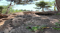
NCS is a rad trail Amazingly nasty rock gardens that are wide enough for you to be creative on line choice. There are some really techy sections that require a quick peak before rolling through them. Overall a really awesome trail.

Bike Park

Local Trail Association
Traditionally Indigenous Territory

Recent Activity on Trail

Past Week
  • 2 rides
  • 28 miles average
6 Months
  • 6 rides
  • 24 miles avg distance
All
  • 169 rides
  • Last: Jun 6, 2026
c1c2c3c4
January
February
March
April
May
June
July
August
September
October
November
December
update trails status or condition

NCS Trail Reports

statusdatedescription
Apr 16, 2026 @ 11:25am (America/Denver)
Apr 16, 2026
reporter Seasonal Closure
Apr 16, 2026 @ 10:51am (America/Denver)
Apr 16, 2026
Oct 13, 2025 @ 8:04am (America/Denver)
Oct 13, 2025
reporter closed for the season will reopen Spring 2026
Aug 30, 2025 @ 9:44am
Aug 30, 2025
reporter Recent rains have improved conditions.
Jun 20, 2025 @ 4:31pm
Jun 20, 2025
reporter
more »
Status:
on Apr 16, 2026
Snow Covered
Avg: 4.34 (26 votes)
Your vote: 0

view (1,710)
close
3D
Trail Conditions
  • Unknown
  • Snow Groomed
  • Snow Packed
  • Snow Covered
  • Snow Cover Partial
  • Freeze/thaw Cycle
  • Icy
  • Prevalent Mud
  • Wet
  • Variable
  • Ideal
  • Dry
  • Very Dry
Trail Flow (Ridden Direction)
Trailforks scans users ridelogs to determine the most popular direction each trail is ridden. A good flowing trail network will have most trails flowing in a single direction according to their intension.
The colour categories are based on what percentage of riders are riding a trail in its intended direction.
  • > 96%
  • > 90%
  • > 80%
  • > 70%
  • > 50%
  • < 50%
  • bi-directional trail
  • no data
Trail Last Ridden
Trailforks scans ridelogs to determine the last time a trail was ridden.
  • < 2 days
  • < 1 week
  • < 2 weeks
  • < 1 month
  • < 6 months
  • > 6 months
Trail Ridden Direction
The intended direction a trail should be ridden.
  • Downhill Only
  • Downhill Primary
  • Both Directions
  • Uphill Primary
  • Uphill Only
  • One Direction
Contribute Details
Colors indicate trail is missing specified detail.
  • Description
  • Photos
  • Description & Photos
  • Videos
Trail Popularity ?
Trailforks scans ridelogs to determine which trails are ridden the most in the last 9 months. Trails are compared with nearby trails in the same city region with a possible 25 colour shades. Think of this as a heatmap, more rides = more kinetic energy = warmer colors.
  • most popular
  • popular
  • less popular
  • not popular
ATV/ORV/OHV Filter
Max Vehicle Width
inches
US Cell Coverage
Legend
cell carrier legend

Radar Time
Activity Recordings
Trailforks uses anonymized public activity data. ?
Activity Recordings
Trailforks uses anonymized public activity data. ?
Personal Heatmap
Activity Types
all / none
Options
2
Date range month
Winter Trails
Warning A routing network for winter maps does not exist. Selecting trails using the winter trails layer has been disabled.
Missing Trails
Most Popular
Least Popular
Trails are colored based on popularity. The more popular a trail is, the more red. Less popular trails trend towards green.
Jump Magnitude Heatmap
Heatmap of where riders jump on trails. Zoom in to see individual jumps, click circles to view jump details.
BC Backroad Status

Service Road Atlas is a free to use, community-driven service for viewing and creating reports on the numerous back-country service roads around B.C. and Alberta.

map legend
Slope Aspect
Direction the slope faces
Flat N NE E SE S SW W NW
Trails Deemphasized
Trails are shown in grey.
disable
Only show trails with no bike usage.
Enable
Suggested Layers
Based on selected activity type

    Save the current map location and zoom level as your default home location whenever this page is loaded.

    Save
        Directions to ncs trailhead (40.625740, -111.483800)

        Photos

        47 more »
        899 |
        Jun 23, 2007 @ 4:28pm
        Jun 23, 2007
        583 |
        Jun 23, 2007 @ 5:08pm
        Jun 23, 2007
        305 |
        Jun 23, 2007 @ 5:24pm
        Jun 23, 2007
        660 |
        Dec 13, 2007 @ 10:54am
        Dec 13, 2007

        Videos

        11 more »
        youtuber Deer Valley Bike Park pt4  : NCS Until I Ran...
        4:14 | 712 | Jul 19, 2021 , Park City
        NCS -- Deer Valley
        4:36 | 669 | Jun 21, 2021 , Park City
        NCS the Business portions
        2:23 | 892 | Jul 7, 2019 , Park City
        Crash at Deer valley
        0:14 | | Sep 1, 2023 , Park City

        Trail Lists

        Routes with this trail

        2.0 15 miles 2,611 ft 44
        After work big dv loop. Up to silver lake from snow park to top of nail driver back down to the bottom.
        3.0 14 miles 2,605 ft 50 Loop
        Get the legs in shape and the hair flowing
        12 miles 2,548 ft 30
        Nice tour of the bottom portion of DV and St. Regis.

        8 Reviews & Comments


        We hope you've been enjoying Trailforks!

        Create a FREE account to view trail comments and much more.

        • By toddTF Pro Trailforks & contributors
        • #11369 - 8,715 views

        Frequently Asked Questions About NCS

        Where is NCS located?
        NCS is located in Deer Valley Resort, Park City, Utah, United States. It is part of the Deer Valley Resort trail network. The trailhead is located at coordinates 40.62574, -111.4838.
        How hard is NCS?
        NCS is rated as Double Black Diamond difficulty. The physical rating is Hard. The average grade is 22.6%.
        What is the elevation gain for NCS?
        The trail has 299 m of elevation descent. The elevation ranges from 2,250 m to 2,549 m.
        Is NCS a point to point trail?
        Yes, NCS is a point to point trail. The direction is Downhill Only. The trail type is singletrack.

        Hit the Trail

        Open in App

        Get this trail on your phone instantly.
        open trail in app

        Download Trail

        Save to wishlist, Garmin & download.
        save the trail

        Find Related Routes

        Find routes and users activities that include this trail.
        find routes for this trail

        You must enter a description before submitting.