more stats
2,057 ft
Distance
2 ft
Climb
-242 ft
Descent
00:03:52
Avg time
-240 ft
Altitude change
1,207 ft
Altitude min
1,449 ft
Altitude max
1,449 ft
Altitude start
1,211 ft
Altitude end
-11.7%
Grade
-29.9%
Grade max
2.9%
Grade min
108 ft
Distance climb
1,811 ft
Distance down
102 ft
Distance flat
00:03:52
Avg time

NE Style Details

  • Activities
    • Mountain Bike
  • Riding Area
    Highland Mountain Bike Park
    Northfield, New Hampshire
  • AKA
    New England Style
  • Difficulty Rating
  • Local Popularity
    65 in Mountain Biking
  • Global Ranking
    #1118 in Mountain Biking
  • Trail Type
    Machine Groomed
  • Bike Type
    DH
  • Direction
    Downhill Only
  • Physical Rating
    Hard
  • Dogs Allowed
    Yes
  • eBike Allowed
  • TTFs on Trail
    Bridge, Drop, Jump, Rock Face, Teeter Totter, Wallride
  • Land Owner

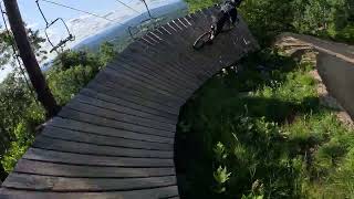
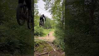
A super fun freeride trail starting with the Pinkbike drop, an impressive 12' by 12' drop followed non stop features with lots of speed and perfect flow.

Bike Park

Traditionally Indigenous Territory

Recent Activity on Trail

Past Week
  • 19 rides
  • 15 miles average
6 Months
  • 70 rides
  • 16 miles avg distance
All
  • 1,113 rides
  • Last: Jun 21, 2026
c1c2c3c4
January
February
March
April
May
June
July
August
September
October
November
December
Status:
on Jun 21, 2026
Ideal
Avg: 4.6 (22 votes)
Your vote: 0

view (10,751)
close
3D
Trail Conditions
  • Unknown
  • Snow Groomed
  • Snow Packed
  • Snow Covered
  • Snow Cover Partial
  • Freeze/thaw Cycle
  • Icy
  • Prevalent Mud
  • Wet
  • Variable
  • Ideal
  • Dry
  • Very Dry
Trail Flow (Ridden Direction)
Trailforks scans users ridelogs to determine the most popular direction each trail is ridden. A good flowing trail network will have most trails flowing in a single direction according to their intension.
The colour categories are based on what percentage of riders are riding a trail in its intended direction.
  • > 96%
  • > 90%
  • > 80%
  • > 70%
  • > 50%
  • < 50%
  • bi-directional trail
  • no data
Trail Last Ridden
Trailforks scans ridelogs to determine the last time a trail was ridden.
  • < 2 days
  • < 1 week
  • < 2 weeks
  • < 1 month
  • < 6 months
  • > 6 months
Trail Ridden Direction
The intended direction a trail should be ridden.
  • Downhill Only
  • Downhill Primary
  • Both Directions
  • Uphill Primary
  • Uphill Only
  • One Direction
Contribute Details
Colors indicate trail is missing specified detail.
  • Description
  • Photos
  • Description & Photos
  • Videos
Trail Popularity ?
Trailforks scans ridelogs to determine which trails are ridden the most in the last 9 months. Trails are compared with nearby trails in the same city region with a possible 25 colour shades. Think of this as a heatmap, more rides = more kinetic energy = warmer colors.
  • most popular
  • popular
  • less popular
  • not popular
ATV/ORV/OHV Filter
Max Vehicle Width
inches
US Cell Coverage
Legend
cell carrier legend

Radar Time
Activity Recordings
Trailforks uses anonymized public activity data. ?
Activity Recordings
Trailforks uses anonymized public activity data. ?
Personal Heatmap
Activity Types
all / none
Options
2
Date range month
Winter Trails
Warning A routing network for winter maps does not exist. Selecting trails using the winter trails layer has been disabled.
Missing Trails
Most Popular
Least Popular
Trails are colored based on popularity. The more popular a trail is, the more red. Less popular trails trend towards green.
Jump Magnitude Heatmap
Heatmap of where riders jump on trails. Zoom in to see individual jumps, click circles to view jump details.
BC Backroad Status

Service Road Atlas is a free to use, community-driven service for viewing and creating reports on the numerous back-country service roads around B.C. and Alberta.

map legend
Slope Aspect
Direction the slope faces
Flat N NE E SE S SW W NW
Trails Deemphasized
Trails are shown in grey.
disable
Only show trails with no bike usage.
Enable
Suggested Layers
Based on selected activity type

    Save the current map location and zoom level as your default home location whenever this page is loaded.

    Save
        Directions to ne-style trailhead (43.398110, -71.550440)

        Photos

        72 more »
        1,289 |
        Mar 14, 2018 @ 3:49am
        Mar 14, 2018
        1,711 |
        Jan 5, 2016 @ 5:18pm
        Jan 5, 2016
        930 |
        Oct 9, 2015 @ 12:15pm
        Oct 9, 2015
        68 |
        Jul 1, 2024 @ 3:06pm
        Jul 1, 2024

        Videos

        39 more »
        youtuber He SKIPPED SCHOOL to Ride the BIKE PARK!
        16:15 | 1187 | Nov 14, 2019 , Northfield
        UPPER NE STYLE B-LINE Following Bryce at...
        0:33 | 78 | Jul 30, 2025 , Northfield
        Sending the BIGGEST Mountain Bike Drop That...
        0:32 | 43 | Jul 6, 2025 , Northfield
        Sideboob Crash
        0:13 | 290 | Dec 25, 2021 , Northfield

        5 Reviews & Comments


        We hope you've been enjoying Trailforks!

        Create a FREE account to view trail comments and much more.

        • By benmob1898 & contributors
        • #4874 - 22,945 views

        Frequently Asked Questions About NE Style

        Where is NE Style located?
        NE Style is located in Highland Mountain Bike Park, Northfield, New Hampshire, United States. It is part of the Highland Mountain Bike Park trail network. The trailhead is located at coordinates 43.39811, -71.55044.
        How hard is NE Style?
        NE Style is rated as Double Black Diamond difficulty. The physical rating is Hard. The average grade is 11.7%.
        What is the elevation gain for NE Style?
        NE Style has 2 ft of elevation gain. The trail has 242 ft of elevation descent. The elevation ranges from 1,207 ft to 1,449 ft.
        Is NE Style a point to point trail?
        Yes, NE Style is a point to point trail. The direction is Downhill Only. The trail type is machine groomed.

        Hit the Trail

        Open in App

        Get this trail on your phone instantly.
        open trail in app

        Download Trail

        Save to wishlist, Garmin & download.
        save the trail

        Find Related Routes

        Find routes and users activities that include this trail.
        find routes for this trail

        You must enter a description before submitting.