more stats
2,310 ft
Distance
-522 ft
Descent
00:04:33
Avg time
-522 ft
Altitude change
4,839 ft
Altitude min
5,361 ft
Altitude max
5,361 ft
Altitude start
4,839 ft
Altitude end
-22.6%
Grade
-55.3%
Grade max
-5.3%
Grade min
2,310 ft
Distance down
00:04:33
Avg time

Nérine - Black section Details

  • Activities
    • Mountain Bike
    • E-Bike
  • Riding Area
  • Difficulty Rating
  • Local Popularity
    40 in Mountain Biking [+]
    • 5 in E-Biking
  • Global Ranking
    #113241 in Mountain Biking [+]
    • #106944 in E-Biking
  • Trail Type
    Singletrack
  • Bike Type
    DH, AM
  • Physical Rating
    Hard
  • Trail Visibility
    Always easy to follow
  • Season
    June to October
  • eBike Allowed
  • TTFs on Trail
    Jump, Gap Jump, Rock Garden
  • Land Owner
    Leysin Bike Park

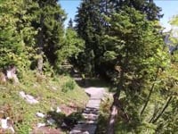
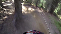
An expert level downhill trail. The trail starts with two large gap jumps that have go-arounds. The middle fo the trail features a steep and loose limestone rock garden with some tight switchback (Enduro rider will love it) then it's go back in the woods through a fast chute and ends with a jump line. You can link to the Fabiola Jump Line after.

It used to be the technical section of the World Cup track back in 2000 when Leysin host a Downhill World Cup Race.

Access Info

Via the Gondola of La Berneuse

Disclaimer

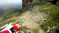
The middle rock section is loose - Be focus and watch the lines before droping.

Bike Park

Recent Activity on Trail

Past Week
  • 2 rides
  • 23 miles average
6 Months
  • 4 rides
  • 21 miles avg distance
All
  • 15 rides
  • Last: Jun 21, 2026
c1c2c3c4
January
February
March
April
May
June
July
August
September
October
November
December
update trails status or condition

Nérine - Black... Trail Reports

Status:
on Jun 20, 2026
Dry
Avg: 4.13 (1 votes)
Your vote: 0

view (147)
close
3D
Trail Conditions
  • Unknown
  • Snow Groomed
  • Snow Packed
  • Snow Covered
  • Snow Cover Partial
  • Freeze/thaw Cycle
  • Icy
  • Prevalent Mud
  • Wet
  • Variable
  • Ideal
  • Dry
  • Very Dry
Trail Flow (Ridden Direction)
Trailforks scans users ridelogs to determine the most popular direction each trail is ridden. A good flowing trail network will have most trails flowing in a single direction according to their intension.
The colour categories are based on what percentage of riders are riding a trail in its intended direction.
  • > 96%
  • > 90%
  • > 80%
  • > 70%
  • > 50%
  • < 50%
  • bi-directional trail
  • no data
Trail Last Ridden
Trailforks scans ridelogs to determine the last time a trail was ridden.
  • < 2 days
  • < 1 week
  • < 2 weeks
  • < 1 month
  • < 6 months
  • > 6 months
Trail Ridden Direction
The intended direction a trail should be ridden.
  • Downhill Only
  • Downhill Primary
  • Both Directions
  • Uphill Primary
  • Uphill Only
  • One Direction
Contribute Details
Colors indicate trail is missing specified detail.
  • Description
  • Photos
  • Description & Photos
  • Videos
Trail Popularity ?
Trailforks scans ridelogs to determine which trails are ridden the most in the last 9 months. Trails are compared with nearby trails in the same city region with a possible 25 colour shades. Think of this as a heatmap, more rides = more kinetic energy = warmer colors.
  • most popular
  • popular
  • less popular
  • not popular
ATV/ORV/OHV Filter
Max Vehicle Width
inches
US Cell Coverage
Legend
cell carrier legend

Radar Time
Activity Recordings
Trailforks uses anonymized public activity data. ?
Activity Recordings
Trailforks uses anonymized public activity data. ?
Personal Heatmap
Activity Types
all / none
Options
2
Date range month
Winter Trails
Warning A routing network for winter maps does not exist. Selecting trails using the winter trails layer has been disabled.
Missing Trails
Most Popular
Least Popular
Trails are colored based on popularity. The more popular a trail is, the more red. Less popular trails trend towards green.
Jump Magnitude Heatmap
Heatmap of where riders jump on trails. Zoom in to see individual jumps, click circles to view jump details.
BC Backroad Status

Service Road Atlas is a free to use, community-driven service for viewing and creating reports on the numerous back-country service roads around B.C. and Alberta.

map legend
Slope Aspect
Direction the slope faces
Flat N NE E SE S SW W NW
Trails Deemphasized
Trails are shown in grey.
disable
Only show trails with no bike usage.
Enable
Suggested Layers
Based on selected activity type

    Save the current map location and zoom level as your default home location whenever this page is loaded.

    Save
        Directions to nerine-black-section trailhead (46.360620, 7.018370)

        Photos

        17 more »
        115 |
        Jun 30, 2021 @ 12:13am
        Jun 30, 2021
        193 |
        Jun 30, 2021 @ 12:14am
        Jun 30, 2021
        83 |
        Oct 4, 2020 @ 3:47am
        Oct 4, 2020
        76 |
        Oct 4, 2020 @ 3:47am
        Oct 4, 2020

        Videos

        6 more »
        ' Faragnats ' - Black track POV
        0:38 | 319 | Jul 28, 2019 , Leysin
        two minutes with Morgane Charre
        2:00 | 146 | May 18, 2016 , Leysin
        DH black
        5:58 | 634 | Sep 1, 2011 , Leysin
        Super Morzine Black 2013
        2:25 | 425 | Aug 8, 2013 , Leysin

        Reviews / Comments

        No reviews yet, be the first to write a review or ask a question.
        Use trail reports to comment on trail conditions.


        We hope you've been enjoying Trailforks!

        Create a FREE account to view trail comments and much more.

        • By BenJCOTF Pro & contributors
        • #194543 - 1,273 views

        Frequently Asked Questions About Nérine - Black section

        Where is Nérine - Black section located?
        Nérine - Black section is located in Leysin Bike Park, Leysin, Switzerland. It is part of the Leysin Bike Park trail network. The trailhead is located at coordinates 46.36062, 7.01837.
        How hard is Nérine - Black section?
        Nérine - Black section is rated as Black difficulty. The physical rating is Hard. The average grade is 22.6%.
        What is the elevation gain for Nérine - Black section?
        The trail has 159 m of elevation descent. The elevation ranges from 1,475 m to 1,634 m.
        How long is Nérine - Black section?
        Nérine - Black section is 704.0 m long. The trail type is singletrack.

        Hit the Trail

        Open in App

        Get this trail on your phone instantly.
        open trail in app

        Download Trail

        Save to wishlist, Garmin & download.
        save the trail

        Find Related Routes

        Find routes and users activities that include this trail.
        find routes for this trail

        You must enter a description before submitting.