more stats
5.2 miles
Distance
329 ft
Climb
-2,773 ft
Descent
00:37:05
Avg time
-2,444 ft
Altitude change
575 ft
Altitude min
3,019 ft
Altitude max
3,019 ft
Altitude start
574 ft
Altitude end
-9%
Grade
-68.7%
Grade max
40.2%
Grade min
4,003 ft
Distance climb
4 miles
Distance down
482 ft
Distance flat
00:37:05
Avg time

Nestor Peak Details

  • Activities
    • Mountain Bike
    • E-Bike
    • Hike
    • Trail Running
  • Riding Area
    Buck Creek / Nestor Peak
    White Salmon, Washington
  • Difficulty Rating
  • Voted Difficulty
    Blue (1 vote)
  • Local Popularity
    90 in Mountain Biking [+]
    • 90 in E-Biking
    • 5 in Trail Running
    • 5 in Hiking
  • Global Ranking
    #41123 in Mountain Biking [+]
    • #3076 in E-Biking
    • #128233 in Trail Running
    • #121318 in Hiking
  • Trail Type
    Singletrack
  • Bike Type
    DH, AM, XC
  • Direction
    Downhill Primary
    Popular Direction Shown
  • Season
    May-Nov
  • Dogs Allowed
    Yes
  • eBike Allowed
  • Ride in Rain
    Yes
  • Land Owner
    DNR

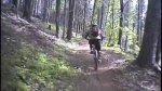
A shuttle-able trail for all bikes. Very fast (brake burner), nothing technical. Very little pedaling overall. Old Forests. Horseback riders are known to 'love' this trail too. Be on the lookout for trail manure. The road up requires a 4X4 at the very top- steep drive.
On the way down, if you abhor climbing, you can pop off the trail at mile 1.8 to the N-1300 road and follow it to the campground and then rejoin the trail there.
Nestor Peak is part of the Half Monte ride which is a longer 13+mile shuttle ride.

Access Info

From Hwy14 head north on State Route 141 Spur to NW Lake Road. Drive across the bridge and on the left is a day use area. That is a great base meeting area if doing the 2 car shuttle system. To drive to the summit- Lake Rd to Nestor Peak Rd.

Local Trail Association
Traditionally Indigenous Territory

Recent Activity on Trail

Past Week
  • 0 rides
  •  
6 Months
  • 11 rides
  • 14 miles avg distance
All
  • 143 rides
  • Last: Jun 19, 2026
c1c2c3c4
January
February
March
April
May
June
July
August
September
October
November
December
update trails status or condition

Nestor Peak Trail Reports

statusdatedescription
Mar 7, 2026 @ 2:12pm (America/Los_Angeles)
Mar 7, 2026
Jun 24, 2025 @ 6:57pm
Jun 24, 2025
Big tree cleared, thx
Jun 20, 2025 @ 5:58pm
Jun 20, 2025
Tree down
Jun 19, 2025 @ 7:35pm
Jun 19, 2025
Big tree still across trail in lower section - very difficult to climb over.
Jun 3, 2025 @ 12:05pm
Jun 3, 2025
One fallen tree in lower section - difficult to climb over. Wish I carried my folding saw to cut off some of the branches
more »
Status:
on Mar 7, 2026
Ideal
Avg: 3.72 (19 votes)
Your vote: 0

view (659)
close
3D
Trail Conditions
  • Unknown
  • Snow Groomed
  • Snow Packed
  • Snow Covered
  • Snow Cover Partial
  • Freeze/thaw Cycle
  • Icy
  • Prevalent Mud
  • Wet
  • Variable
  • Ideal
  • Dry
  • Very Dry
Trail Flow (Ridden Direction)
Trailforks scans users ridelogs to determine the most popular direction each trail is ridden. A good flowing trail network will have most trails flowing in a single direction according to their intension.
The colour categories are based on what percentage of riders are riding a trail in its intended direction.
  • > 96%
  • > 90%
  • > 80%
  • > 70%
  • > 50%
  • < 50%
  • bi-directional trail
  • no data
Trail Last Ridden
Trailforks scans ridelogs to determine the last time a trail was ridden.
  • < 2 days
  • < 1 week
  • < 2 weeks
  • < 1 month
  • < 6 months
  • > 6 months
Trail Ridden Direction
The intended direction a trail should be ridden.
  • Downhill Only
  • Downhill Primary
  • Both Directions
  • Uphill Primary
  • Uphill Only
  • One Direction
Contribute Details
Colors indicate trail is missing specified detail.
  • Description
  • Photos
  • Description & Photos
  • Videos
Trail Popularity ?
Trailforks scans ridelogs to determine which trails are ridden the most in the last 9 months. Trails are compared with nearby trails in the same city region with a possible 25 colour shades. Think of this as a heatmap, more rides = more kinetic energy = warmer colors.
  • most popular
  • popular
  • less popular
  • not popular
ATV/ORV/OHV Filter
Max Vehicle Width
inches
US Cell Coverage
Legend
cell carrier legend

Radar Time
Activity Recordings
Trailforks uses anonymized public activity data. ?
Activity Recordings
Trailforks uses anonymized public activity data. ?
Personal Heatmap
Activity Types
all / none
Options
2
Date range month
Winter Trails
Warning A routing network for winter maps does not exist. Selecting trails using the winter trails layer has been disabled.
Missing Trails
Most Popular
Least Popular
Trails are colored based on popularity. The more popular a trail is, the more red. Less popular trails trend towards green.
Jump Magnitude Heatmap
Heatmap of where riders jump on trails. Zoom in to see individual jumps, click circles to view jump details.
BC Backroad Status

Service Road Atlas is a free to use, community-driven service for viewing and creating reports on the numerous back-country service roads around B.C. and Alberta.

map legend
Slope Aspect
Direction the slope faces
Flat N NE E SE S SW W NW
Trails Deemphasized
Trails are shown in grey.
disable
Only show trails with no bike usage.
Enable
Suggested Layers
Based on selected activity type

    Save the current map location and zoom level as your default home location whenever this page is loaded.

    Save
        Directions to nestor-peak trailhead (45.815040, -121.571290)

        Photos

        39 more »
        250 |
        Dec 4, 2023 @ 5:42pm
        Dec 4, 2023
        471 |
        May 27, 2009 @ 8:38pm
        May 27, 2009
        432 |
        May 27, 2009 @ 8:38pm
        May 27, 2009
        384 |
        May 27, 2009 @ 8:38pm
        May 27, 2009

        Videos

        3 more »
        youtuber Nestor Peak
        5:16 | 1975 | Dec 29, 2018 , White Salmon
        Below The Pines | Torsenn Brown
        2:48 | 1034 | Sep 8, 2017 , White Salmon
        Nestor Peak DH
        5:06 | 827 | May 27, 2009 , White Salmon

        Routes with this trail

        4.0 13 miles 1,970 ft 8
        The Half Monte ride on the Buck Creek Loop has it all! remote in feel - ripping fast downhill and grunter...
        3.0 21 miles 5,403 ft 9
        The Full Monte is an epic! While not for everyone, the stout at heart will enjoy the grueling climbs and...

        8 Reviews & Comments


        We hope you've been enjoying Trailforks!

        Create a FREE account to view trail comments and much more.

        • By northwestdhdad EMBA-SW & contributors
        • #65127 - 17,839 views

        Frequently Asked Questions About Nestor Peak

        Where is Nestor Peak located?
        Nestor Peak is located in Buck Creek / Nestor Peak, White Salmon, Washington, United States. It is part of the Buck Creek / Nestor Peak trail network. The trailhead is located at coordinates 45.81504, -121.57129.
        How hard is Nestor Peak?
        Nestor Peak is rated as Blue difficulty. The average grade is 9%.
        What is the elevation gain for Nestor Peak?
        Nestor Peak has 329 ft of elevation gain. The trail has 2,773 ft of elevation descent. The elevation ranges from 575 ft to 3,019 ft.
        Is Nestor Peak a point to point trail?
        Nestor Peak is not a point to point trail. The direction is Downhill Primary. The trail type is singletrack.

        Hit the Trail

        Open in App

        Get this trail on your phone instantly.
        open trail in app

        Download Trail

        Save to wishlist, Garmin & download.
        save the trail

        Find Related Routes

        Find routes and users activities that include this trail.
        find routes for this trail

        You must enter a description before submitting.