more stats
1,080 ft
Distance
30 ft
Climb
-62 ft
Descent
00:01:05
Avg time
-32 ft
Altitude change
360 ft
Altitude min
407 ft
Altitude max
407 ft
Altitude start
375 ft
Altitude end
-75.906%
Grade max
34.892%
Grade min
213 ft
Distance climb
419 ft
Distance down
449 ft
Distance flat
00:01:05
Avg time

Nga Tuna Details

  • Activities
    • Mountain Bike
    • E-Bike
    • Hike
    • Trail Running
  • Riding Area
  • Difficulty Rating
  • Local Popularity
    90 in Mountain Biking [+]
    • 80 in E-Biking
    • 35 in Trail Running
    • 5 in Hiking
  • Global Ranking
    #29015 in Mountain Biking [+]
    • #33134 in E-Biking
    • #123233 in Trail Running
    • #124637 in Hiking
  • Trail Type
    Singletrack
  • Bike Type
    DH, AM, XC
  • Direction
    Downhill Only
    Popular Direction Shown
  • Physical Rating
    Moderate
  • Season
    All year
  • Dogs Allowed
    Yes
  • eBike Allowed
    Yes up to Class 1
  • Ride in Rain
    Yes
  • Land Owner

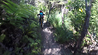
Nga Tuna is the return trail for Spoonhill/491 for those who do not want to complete all of Spoonhill. This will take you back to Wetland loop.

Turn left to head back to the car park or right to head into Wetland loop and towards The Directa, Westside.

Access Info

Turn right onto Nga Tuna off Spoonhil

Local Trail Association

Recent Activity on Trail

Past Week
  • 1 rides
  • 6 miles average
6 Months
  • 76 rides
  • 11 miles avg distance
All
  • 1,040 rides
  • Last: Jun 16, 2026
c1c2c3c4
January
February
March
April
May
June
July
August
September
October
November
December
Status:
on May 13, 2025
Ideal
Avg: 3.99 (8 votes)
Your vote: 0

view (6,974)
close
3D
Trail Conditions
  • Unknown
  • Snow Groomed
  • Snow Packed
  • Snow Covered
  • Snow Cover Partial
  • Freeze/thaw Cycle
  • Icy
  • Prevalent Mud
  • Wet
  • Variable
  • Ideal
  • Dry
  • Very Dry
Trail Flow (Ridden Direction)
Trailforks scans users ridelogs to determine the most popular direction each trail is ridden. A good flowing trail network will have most trails flowing in a single direction according to their intension.
The colour categories are based on what percentage of riders are riding a trail in its intended direction.
  • > 96%
  • > 90%
  • > 80%
  • > 70%
  • > 50%
  • < 50%
  • bi-directional trail
  • no data
Trail Last Ridden
Trailforks scans ridelogs to determine the last time a trail was ridden.
  • < 2 days
  • < 1 week
  • < 2 weeks
  • < 1 month
  • < 6 months
  • > 6 months
Trail Ridden Direction
The intended direction a trail should be ridden.
  • Downhill Only
  • Downhill Primary
  • Both Directions
  • Uphill Primary
  • Uphill Only
  • One Direction
Contribute Details
Colors indicate trail is missing specified detail.
  • Description
  • Photos
  • Description & Photos
  • Videos
Trail Popularity ?
Trailforks scans ridelogs to determine which trails are ridden the most in the last 9 months. Trails are compared with nearby trails in the same city region with a possible 25 colour shades. Think of this as a heatmap, more rides = more kinetic energy = warmer colors.
  • most popular
  • popular
  • less popular
  • not popular
ATV/ORV/OHV Filter
Max Vehicle Width
inches
US Cell Coverage
Legend
cell carrier legend

Radar Time
Activity Recordings
Trailforks uses anonymized public activity data. ?
Activity Recordings
Trailforks uses anonymized public activity data. ?
Personal Heatmap
Activity Types
all / none
Options
2
Date range month
Winter Trails
Warning A routing network for winter maps does not exist. Selecting trails using the winter trails layer has been disabled.
Missing Trails
Most Popular
Least Popular
Trails are colored based on popularity. The more popular a trail is, the more red. Less popular trails trend towards green.
Jump Magnitude Heatmap
Heatmap of where riders jump on trails. Zoom in to see individual jumps, click circles to view jump details.
BC Backroad Status

Service Road Atlas is a free to use, community-driven service for viewing and creating reports on the numerous back-country service roads around B.C. and Alberta.

map legend
Slope Aspect
Direction the slope faces
Flat N NE E SE S SW W NW
Trails Deemphasized
Trails are shown in grey.
disable
Only show trails with no bike usage.
Enable
Suggested Layers
Based on selected activity type

    Save the current map location and zoom level as your default home location whenever this page is loaded.

    Save
        Directions to nga-tuna trailhead (-41.246720, 174.929820)

        Photos

        3 more »
        72 |
        Feb 6, 2019 @ 11:30pm
        Feb 6, 2019
        113 |
        Jun 24, 2017 @ 6:30pm
        Jun 24, 2017
        100 |
        Jun 24, 2017 @ 6:29pm
        Jun 24, 2017

        Videos

        4 more »
        youtuber FAST FUN - Nga Tuna Mountain Bike Trail (Grade...
        0:19 | 406 | Mar 7, 2021 , Lower Hutt
        youtuber Nga Tuna @ Wainui Trail Project
        0:17 | 489 | Apr 4, 2019 , Lower Hutt
        Nga Tuna | Wainui Bike Park
        0:27 | 310 | Jan 22, 2021 , Lower Hutt
        9yo - Kisses bank
        0:10 | 110 | Jan 12, 2021 , Lower Hutt

        Routes with this trail

        4 miles 819 ft 8 Loop
        A good size circuit from the carpark. Take the to . Climb to , and carry onto climbing until Labyrinth. At...
        5 miles 1,183 ft 18 Loop
        PNP 2020 MTB Spring Series R1 SLong Loop Waiu Trail Park
        4 miles 897 ft 20
        NZSS Individual Cross Country 2020

        Reviews / Comments

        No reviews yet, be the first to write a review or ask a question.
        Use trail reports to comment on trail conditions.


        We hope you've been enjoying Trailforks!

        Create a FREE account to view trail comments and much more.

        • By nikholden & contributors
        • #17351 - 4,352 views

        Frequently Asked Questions About Nga Tuna

        Where is Nga Tuna located?
        Nga Tuna is located in Wainuiomata Trail Park (WTP), Lower Hutt, New Zealand. It is part of the Wainuiomata Trail Park (WTP) trail network. The trailhead is located at coordinates -41.24672, 174.92982.
        How hard is Nga Tuna?
        Nga Tuna is rated as Blue difficulty. The physical rating is Moderate.
        What is the elevation gain for Nga Tuna?
        Nga Tuna has 30 ft of elevation gain. The trail has 62 ft of elevation descent. The elevation ranges from 360 ft to 407 ft.
        Is Nga Tuna a point to point trail?
        Yes, Nga Tuna is a point to point trail. The direction is Downhill Only. The trail type is singletrack.

        Hit the Trail

        Open in App

        Get this trail on your phone instantly.
        open trail in app

        Download Trail

        Save to wishlist, Garmin & download.
        save the trail

        Find Related Routes

        Find routes and users activities that include this trail.
        find routes for this trail

        You must enter a description before submitting.