more stats
5,082 ft
Distance
254 ft
Climb
-480 ft
Descent
00:14:09
Avg time
-228 ft
Altitude change
535 ft
Altitude min
908 ft
Altitude max
908 ft
Altitude start
679 ft
Altitude end
-4.5%
Grade
-70.1%
Grade max
48.8%
Grade min
2,215 ft
Distance climb
2,156 ft
Distance down
709 ft
Distance flat
00:14:09
Avg time

Nikau Valley Details

  • Activities
    • Mountain Bike
    • E-Bike
    • Hike
    • Trail Running
  • Riding Area
  • Difficulty Rating
  • Voted Difficulty
    Black Diamond (5 votes)
  • Local Popularity
    65 in Mountain Biking [+]
    • 65 in E-Biking
    • 40 in Trail Running
    • 85 in Hiking
  • Global Ranking
    #55624 in Mountain Biking [+]
    • #48077 in E-Biking
    • #111417 in Trail Running
    • #23924 in Hiking
  • Trail Type
    Singletrack
  • Bike Type
    AM, XC
  • Direction
    Downhill Only
    Popular Direction Shown
  • Climb Difficulty
    Blue
  • Physical Rating
    Hard
  • Trail Visibility
    Always easy to follow
  • Dogs Allowed
    Yes
  • eBike Allowed
    Yes up to Class 1
  • TTFs on Trail
    Bridge, Drop
  • Land Owner

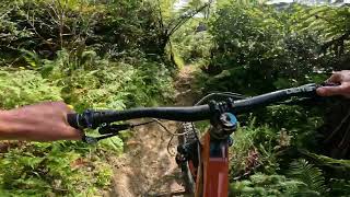
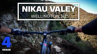
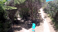
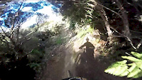
Nikau Valley is one of the hidden gems in Makara Peak Mountain Bike Park. It's slightly out of the way, but with a narrow and rough track surface, that winds through some of the best regenerating bush in the park, you'll be rewarded with a true old-style Advanced (almost Expert in the wet) track that feels comparatively isolated, with an almost back country feel to it.

The first half of the track drops fairly steeply to the stream on the valley floor before some technical uphill brings you back to near the low point on Missing Link.

Built by Makara Peak Supporters in 2000/2001.

Access Info

From Sally Alley you can head down Missing Link and then up the 4WD track to Leaping Lizard and on to Nikau Valley. The easier option is to turn right and head up Three Brothers, Upswing and then turn left onto Upper Leaping Lizard shortly after the intersection with Aratihi.

Disclaimer

Limited mobile phone coverage down in the valley.

Local Trail Association

Recent Activity on Trail

Past Week
  • 1 rides
  • 20 miles average
6 Months
  • 22 rides
  • 15 miles avg distance
All
  • 290 rides
  • Last: Jun 11, 2026
c1c2c3c4
January
February
March
April
May
June
July
August
September
October
November
December
update trails status or condition

Nikau Valley Trail Reports

statusdatedescription
Mar 12, 2026 @ 12:56pm (Pacific/Auckland)
Mar 11, 2026
reporter Hasn't really dried out this "summer" due to regular rain. So a few puddles, and narrow and rutted in places. Plenty of fern fronds to dodge as well.
Feb 28, 2026 @ 7:09am (Pacific/Auckland)
Feb 27, 2026
Wet and slippery in some areas particularly the lower parts.
Jan 25, 2026 @ 7:00am (Pacific/Auckland)
Jan 24, 2026
Slick in some places after the recent rain.
Aug 16, 2025 @ 10:54am
Aug 16, 2025
Slightly greasy - perfect!
May 12, 2025 @ 12:44pm
May 12, 2025
more »
Status:
on Mar 12, 2026
Variable
Avg: 4.15 (15 votes)
Your vote: 0

view (1,995)
close
3D
Trail Conditions
  • Unknown
  • Snow Groomed
  • Snow Packed
  • Snow Covered
  • Snow Cover Partial
  • Freeze/thaw Cycle
  • Icy
  • Prevalent Mud
  • Wet
  • Variable
  • Ideal
  • Dry
  • Very Dry
Trail Flow (Ridden Direction)
Trailforks scans users ridelogs to determine the most popular direction each trail is ridden. A good flowing trail network will have most trails flowing in a single direction according to their intension.
The colour categories are based on what percentage of riders are riding a trail in its intended direction.
  • > 96%
  • > 90%
  • > 80%
  • > 70%
  • > 50%
  • < 50%
  • bi-directional trail
  • no data
Trail Last Ridden
Trailforks scans ridelogs to determine the last time a trail was ridden.
  • < 2 days
  • < 1 week
  • < 2 weeks
  • < 1 month
  • < 6 months
  • > 6 months
Trail Ridden Direction
The intended direction a trail should be ridden.
  • Downhill Only
  • Downhill Primary
  • Both Directions
  • Uphill Primary
  • Uphill Only
  • One Direction
Contribute Details
Colors indicate trail is missing specified detail.
  • Description
  • Photos
  • Description & Photos
  • Videos
Trail Popularity ?
Trailforks scans ridelogs to determine which trails are ridden the most in the last 9 months. Trails are compared with nearby trails in the same city region with a possible 25 colour shades. Think of this as a heatmap, more rides = more kinetic energy = warmer colors.
  • most popular
  • popular
  • less popular
  • not popular
ATV/ORV/OHV Filter
Max Vehicle Width
inches
US Cell Coverage
Legend
cell carrier legend

Radar Time
Activity Recordings
Trailforks uses anonymized public activity data. ?
Activity Recordings
Trailforks uses anonymized public activity data. ?
Personal Heatmap
Activity Types
all / none
Options
2
Date range month
Winter Trails
Warning A routing network for winter maps does not exist. Selecting trails using the winter trails layer has been disabled.
Missing Trails
Most Popular
Least Popular
Trails are colored based on popularity. The more popular a trail is, the more red. Less popular trails trend towards green.
Jump Magnitude Heatmap
Heatmap of where riders jump on trails. Zoom in to see individual jumps, click circles to view jump details.
BC Backroad Status

Service Road Atlas is a free to use, community-driven service for viewing and creating reports on the numerous back-country service roads around B.C. and Alberta.

map legend
Slope Aspect
Direction the slope faces
Flat N NE E SE S SW W NW
Trails Deemphasized
Trails are shown in grey.
disable
Only show trails with no bike usage.
Enable
Suggested Layers
Based on selected activity type

    Save the current map location and zoom level as your default home location whenever this page is loaded.

    Save
        Directions to nikau-valley trailhead (-41.300530, 174.702220)

        Photos

        5 more »
        24 |
        May 11, 2025 @ 9:53pm
        May 11, 2025
        61 |
        Nov 25, 2021 @ 11:09am
        Nov 25, 2021
        69 |
        Nov 25, 2021 @ 11:09am
        Nov 25, 2021
        75 |
        Nov 25, 2021 @ 11:09am
        Nov 25, 2021

        Videos

        4 more »
        youtuber Nikau Valley @ Makara Peak Mountain Bike Park
        8:32 | 42 | Mar 9, 2026 , Wellington
        youtuber BACKCOUNTRY BLISS - Nikau Valley Mountain Bike...
        8:03 | 790 | Aug 15, 2020 , Wellington
        Nikau Valley
        8:09 | 298 | Dec 30, 2017 , Wellington
        Downhill portion of Nikau
        3:30 | 230 | May 29, 2016 , Wellington

        Routes with this trail

        4 miles 1,569 ft 9 Point to Point
        Alternative grade 4 (advanced) route to the summit from the end of . Taking in , the top of and and it...
        10 miles 2,165 ft 26
        Easy Intermediate Loop - longer distance, but suited to less tech riders
        9 miles 2,008 ft 13 Race
        Get the climb out of the way early, followed by great ridge line running, then a nice long downhill back home

        5 Reviews & Comments


        We hope you've been enjoying Trailforks!

        Create a FREE account to view trail comments and much more.

        Frequently Asked Questions About Nikau Valley

        Where is Nikau Valley located?
        Nikau Valley is located in Mākara Peak Mountain Bike Park, Wellington, New Zealand. It is part of the Mākara Peak Mountain Bike Park trail network. The trailhead is located at coordinates -41.30053, 174.70222.
        How hard is Nikau Valley?
        Nikau Valley is rated as Advanced difficulty. The physical rating is Hard. The average grade is 4.5%. The climb difficulty is rated Blue.
        What is the elevation gain for Nikau Valley?
        Nikau Valley has 78 m of elevation gain. The trail has 146 m of elevation descent. The elevation ranges from 163 m to 277 m.
        Is Nikau Valley a point to point trail?
        Yes, Nikau Valley is a point to point trail. The direction is Downhill Only. The trail type is singletrack.

        Hit the Trail

        Open in App

        Get this trail on your phone instantly.
        open trail in app

        Download Trail

        Save to wishlist, Garmin & download.
        save the trail

        Find Related Routes

        Find routes and users activities that include this trail.
        find routes for this trail

        You must enter a description before submitting.