more stats
1,749 ft
Distance
3 ft
Climb
-108 ft
Descent
00:03:44
Avg time
-105 ft
Altitude change
302 ft
Altitude min
410 ft
Altitude max
407 ft
Altitude start
302 ft
Altitude end
-6%
Grade
-22.3%
Grade max
4.2%
Grade min
223 ft
Distance climb
1,316 ft
Distance down
210 ft
Distance flat
00:03:44
Avg time

No Horses Details

  • Activities
    • Mountain Bike
    • Hike
    • Trail Running
  • Riding Area
    Hornby Island
    , British Columbia
  • Difficulty Rating
  • Voted Difficulty
    Blue (1 vote)
  • Local Popularity
    30 in Mountain Biking [+]
    • 5 in Trail Running
    • 5 in Hiking
  • Global Ranking
    #101936 in Mountain Biking [+]
    • #131835 in Trail Running
    • #124933 in Hiking
  • Trail Type
    Singletrack
  • Bike Type
    AM, XC
  • Direction
    Downhill Primary
  • Dogs Allowed
    Yes

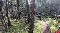
One of the oldest purpose built single-tracks in BC, this trail was started by Sasha LeBaron and and Tig Cross in 1985 and has been continuously improved ever since. It swoops in and out of a gentle dirt ravine with a few side jumps. Many consider No Horses to be an early template for the new-school trails that came later. It became well know in BC during the Hornby BikeFest years of in the 90's when hundreds of off-island racers experienced the joy of rocketing down the smooth berms while throngs of cheering spectators urged them on from the banks above.

Local Trail Association

Recent Activity on Trail

Past Week
  • 2 rides
  • 10 miles average
6 Months
  • 12 rides
  • 11 miles avg distance
All
  • 134 rides
  • Last: Jun 18, 2026
c1c2c3c4
January
February
March
April
May
June
July
August
September
October
November
December
update trails status or condition

No Horses Trail Reports

statusdatedescription
May 26, 2024 @ 5:03pm
May 26, 2024
Thank you for clearing the tree
May 20, 2024 @ 4:01pm
May 20, 2024
Large tree still down in last right hand gully. Very sketchy as it is very hard to see at trail speed until your almost rolling into the gully-...
May 17, 2024 @ 11:53am
May 17, 2024
Large tree down in gully blind entrance
Apr 24, 2024 @ 9:48pm
Apr 24, 2024
Top of No Horses on the bit of trail between Chris and Brads and Washing machine climb there’s a large tree down about waste height
Jun 27, 2022 @ 3:52pm
Jun 27, 2022
more »
Status:
on May 26, 2024
Ideal
Avg: 4.51 (25 votes)
Your vote: 0

view (551)
close
3D
Trail Conditions
  • Unknown
  • Snow Groomed
  • Snow Packed
  • Snow Covered
  • Snow Cover Partial
  • Freeze/thaw Cycle
  • Icy
  • Prevalent Mud
  • Wet
  • Variable
  • Ideal
  • Dry
  • Very Dry
Trail Flow (Ridden Direction)
Trailforks scans users ridelogs to determine the most popular direction each trail is ridden. A good flowing trail network will have most trails flowing in a single direction according to their intension.
The colour categories are based on what percentage of riders are riding a trail in its intended direction.
  • > 96%
  • > 90%
  • > 80%
  • > 70%
  • > 50%
  • < 50%
  • bi-directional trail
  • no data
Trail Last Ridden
Trailforks scans ridelogs to determine the last time a trail was ridden.
  • < 2 days
  • < 1 week
  • < 2 weeks
  • < 1 month
  • < 6 months
  • > 6 months
Trail Ridden Direction
The intended direction a trail should be ridden.
  • Downhill Only
  • Downhill Primary
  • Both Directions
  • Uphill Primary
  • Uphill Only
  • One Direction
Contribute Details
Colors indicate trail is missing specified detail.
  • Description
  • Photos
  • Description & Photos
  • Videos
Trail Popularity ?
Trailforks scans ridelogs to determine which trails are ridden the most in the last 9 months. Trails are compared with nearby trails in the same city region with a possible 25 colour shades. Think of this as a heatmap, more rides = more kinetic energy = warmer colors.
  • most popular
  • popular
  • less popular
  • not popular
ATV/ORV/OHV Filter
Max Vehicle Width
inches
US Cell Coverage
Legend
cell carrier legend

Radar Time
Activity Recordings
Trailforks uses anonymized public activity data. ?
Activity Recordings
Trailforks uses anonymized public activity data. ?
Personal Heatmap
Activity Types
all / none
Options
2
Date range month
Winter Trails
Warning A routing network for winter maps does not exist. Selecting trails using the winter trails layer has been disabled.
Missing Trails
Most Popular
Least Popular
Trails are colored based on popularity. The more popular a trail is, the more red. Less popular trails trend towards green.
Jump Magnitude Heatmap
Heatmap of where riders jump on trails. Zoom in to see individual jumps, click circles to view jump details.
BC Backroad Status

Service Road Atlas is a free to use, community-driven service for viewing and creating reports on the numerous back-country service roads around B.C. and Alberta.

map legend
Slope Aspect
Direction the slope faces
Flat N NE E SE S SW W NW
Trails Deemphasized
Trails are shown in grey.
disable
Only show trails with no bike usage.
Enable
Suggested Layers
Based on selected activity type

    Save the current map location and zoom level as your default home location whenever this page is loaded.

    Save
        Directions to no-horses trailhead (49.514530, -124.671150)

        Photos

        19 more »
        976 |
        Apr 6, 2010 @ 10:34pm
        Apr 6, 2010
        827 |
        Apr 6, 2010 @ 10:37pm
        Apr 6, 2010
        698 |
        Oct 24, 2018 @ 8:18am
        Oct 24, 2018
        92 |
        May 21, 2018 @ 11:34am
        May 21, 2018

        Videos

        1 more »
        190317 No Horses
        0:09 | 295 | Mar 17, 2019 , Hornby Island

        Routes with this trail

        4.0 8 miles 908 ft 29
        Modified from the recommended bike pirate loop so you can start from the ferry
        2.0 12 miles 2,244 ft 58 Loop
        A loop to cover all of the stages from the 2018 Hornby 'duro. Starting point assumes camping at Tribune Bay.

        1 Review & Comments


        We hope you've been enjoying Trailforks!

        Create a FREE account to view trail comments and much more.

        Frequently Asked Questions About No Horses

        Where is No Horses located?
        No Horses is located in Hornby Island, British Columbia, Canada. It is part of the Hornby Island trail network. The trailhead is located at coordinates 49.51453, -124.67115.
        How hard is No Horses?
        No Horses is rated as Blue difficulty. The average grade is 6%.
        What is the elevation gain for No Horses?
        No Horses has 3 ft of elevation gain. The trail has 108 ft of elevation descent. The elevation ranges from 302 ft to 410 ft.
        Is No Horses a point to point trail?
        No Horses is not a point to point trail. The direction is Downhill Primary. The trail type is singletrack.

        Hit the Trail

        Open in App

        Get this trail on your phone instantly.
        open trail in app

        Download Trail

        Save to wishlist, Garmin & download.
        save the trail

        Find Related Routes

        Find routes and users activities that include this trail.
        find routes for this trail

        You must enter a description before submitting.