more stats
3,274 ft
Distance
-409 ft
Descent
00:10:29
Avg time
-410 ft
Altitude change
1,648 ft
Altitude min
2,058 ft
Altitude max
2,058 ft
Altitude start
1,647 ft
Altitude end
-12.5%
Grade
-55.3%
Grade max
-1%
Grade min
3,156 ft
Distance down
118 ft
Distance flat
00:10:29
Avg time

No Joke Details

  • Activities
    • Mountain Bike
    • E-Bike
  • Riding Area
  • Difficulty Rating
  • Voted Difficulty
    Double Black Diamond (2 votes)
  • Local Popularity
    25 in Mountain Biking [+]
    • 10 in E-Biking
  • Global Ranking
    #118468 in Mountain Biking
  • Trail Type
    Singletrack
  • Bike Type
    DH, AM
  • Direction
    Downhill Only
    Popular Direction Shown
  • Physical Rating
    Hard
  • Trail Visibility
    Always easy to follow
  • Season
    spring, summer, fall
  • eBike Allowed
    Yes up to Class 1
  • TTFs on Trail
    Berm, Drop, Rock Face, Rock Garden
  • Year Opened
    2020
  • Land Owner
    BLM

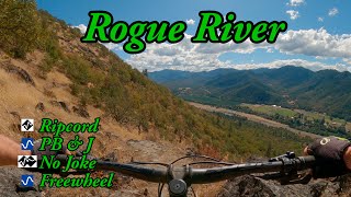
Expert level trail that descends a steep mountainside with multiple mandatory technical features, including steep rock rolls, rock gardens, slabs, and drops. Switchback corners are steep, loose, and often rocky. Some sections including multiple line options for increased difficulty. If the entrance to the trail makes you uncomfortable, do not continue

Access Info

No joke is accessed by climbing Rat Pack and descending Arm Bar. No joke splits off from right side of Arm Bar a couple switchbacks below the service road and connects into Breakdown shortly before Freewheel.

Local Trail Association

Recent Activity on Trail

Past Week
  • 0 rides
  •  
6 Months
  • 0 rides
  •  
All
  • 26 rides
  • Last: Nov 28, 2025
c1c2c3c4
January
February
March
April
May
June
July
August
September
October
November
December
update trails status or condition

No Joke Trail Reports

statusdatedescription
Nov 19, 2023 @ 7:39am
Nov 19, 2023
Trail was clear, but the dirt and rocks were wet making traction in steep chutes a bit extra challenging.
Oct 12, 2023 @ 1:00pm
Oct 12, 2023
Jun 18, 2022 @ 1:55am
Jun 18, 2022
May 1, 2022 @ 11:58pm
May 1, 2022
MoTR Trailhead and Trails closed for construction.
Apr 14, 2022 @ 2:08pm
Apr 14, 2022
more »
Status:
on Nov 19, 2023
Wet
Avg: 4.17 (6 votes)
Your vote: 0

view (204)
close
3D
Trail Conditions
  • Unknown
  • Snow Groomed
  • Snow Packed
  • Snow Covered
  • Snow Cover Partial
  • Freeze/thaw Cycle
  • Icy
  • Prevalent Mud
  • Wet
  • Variable
  • Ideal
  • Dry
  • Very Dry
Trail Flow (Ridden Direction)
Trailforks scans users ridelogs to determine the most popular direction each trail is ridden. A good flowing trail network will have most trails flowing in a single direction according to their intension.
The colour categories are based on what percentage of riders are riding a trail in its intended direction.
  • > 96%
  • > 90%
  • > 80%
  • > 70%
  • > 50%
  • < 50%
  • bi-directional trail
  • no data
Trail Last Ridden
Trailforks scans ridelogs to determine the last time a trail was ridden.
  • < 2 days
  • < 1 week
  • < 2 weeks
  • < 1 month
  • < 6 months
  • > 6 months
Trail Ridden Direction
The intended direction a trail should be ridden.
  • Downhill Only
  • Downhill Primary
  • Both Directions
  • Uphill Primary
  • Uphill Only
  • One Direction
Contribute Details
Colors indicate trail is missing specified detail.
  • Description
  • Photos
  • Description & Photos
  • Videos
Trail Popularity ?
Trailforks scans ridelogs to determine which trails are ridden the most in the last 9 months. Trails are compared with nearby trails in the same city region with a possible 25 colour shades. Think of this as a heatmap, more rides = more kinetic energy = warmer colors.
  • most popular
  • popular
  • less popular
  • not popular
ATV/ORV/OHV Filter
Max Vehicle Width
inches
US Cell Coverage
Legend
cell carrier legend

Radar Time
Activity Recordings
Trailforks uses anonymized public activity data. ?
Activity Recordings
Trailforks uses anonymized public activity data. ?
Personal Heatmap
Activity Types
all / none
Options
2
Date range month
–
Winter Trails
Warning A routing network for winter maps does not exist. Selecting trails using the winter trails layer has been disabled.
Missing Trails
Most Popular
Least Popular
Trails are colored based on popularity. The more popular a trail is, the more red. Less popular trails trend towards green.
Jump Magnitude Heatmap
Heatmap of where riders jump on trails. Zoom in to see individual jumps, click circles to view jump details.
BC Backroad Status

Service Road Atlas is a free to use, community-driven service for viewing and creating reports on the numerous back-country service roads around B.C. and Alberta.

map legend
Slope Aspect
Direction the slope faces
Flat N NE E SE S SW W NW
Trails Deemphasized
Trails are shown in grey.
disable
Only show trails with no bike usage.
Enable
Suggested Layers
Based on selected activity type

    Save the current map location and zoom level as your default home location whenever this page is loaded.

    Save
        Directions to no-joke trailhead (42.425670, -123.150020)

        Photos

        8 more »
        77 |
        Jul 7, 2025 @ 10:25pm
        Jul 7, 2025
        75 |
        Jul 7, 2025 @ 10:25pm
        Jul 7, 2025
        208 |
        Apr 16, 2022 @ 2:37pm
        Apr 16, 2022
        258 |
        Apr 16, 2022 @ 2:37pm
        Apr 16, 2022

        Videos

        1 more »
        youtuber No Joke
        11:08 | 386 | Aug 10, 2023 , Rogue River

        Routes with this trail

        16 miles 3,148 ft 11
        Part 1 of a 3-part series covering all MOTR trails

        4 Reviews & Comments


        We hope you've been enjoying Trailforks!

        Create a FREE account to view trail comments and much more.

        • By BiNARYBiKETF Pro & contributors
        • #299965 - 2,288 views

        Frequently Asked Questions About No Joke

        Where is No Joke located?
        No Joke is located in Mountain of the Rogue Trail System, Rogue River, Oregon, United States. It is part of the Mountain of the Rogue Trail System trail network. The trailhead is located at coordinates 42.42567, -123.15002.
        How hard is No Joke?
        No Joke is rated as Double Black Diamond difficulty. The physical rating is Hard. The average grade is 12.5%.
        What is the elevation gain for No Joke?
        The trail has 409 ft of elevation descent. The elevation ranges from 1,648 ft to 2,058 ft.
        Is No Joke a point to point trail?
        Yes, No Joke is a point to point trail. The direction is Downhill Only. The trail type is singletrack.

        Hit the Trail

        Open in App

        Get this trail on your phone instantly.
        open trail in app

        Download Trail

        Save to wishlist, Garmin & download.
        save the trail

        Find Related Routes

        Find routes and users activities that include this trail.
        find routes for this trail

        You must enter a description before submitting.