more stats
3,159 ft
Distance
117 ft
Climb
-18 ft
Descent
00:05:11
Avg time
99 ft
Altitude change
5,471 ft
Altitude min
5,577 ft
Altitude max
5,471 ft
Altitude start
5,571 ft
Altitude end
3.1%
Grade
-5.2%
Grade max
30.4%
Grade min
2,218 ft
Distance climb
554 ft
Distance down
384 ft
Distance flat
00:05:11
Avg time

Nomad South Details

  • Activities
    • Mountain Bike
    • Horse
    • Hike
    • Trail Running
  • Riding Area
    Horsetooth Mountain
    Fort Collins, Colorado
  • Difficulty Rating
  • Local Popularity
    100 in Mountain Biking [+]
    • 95 in Trail Running
    • 85 in Hiking
    • 5 in Horseback
  • Global Ranking
    #2389 in Mountain Biking [+]
    • #27552 in Trail Running
    • #60618 in Hiking
    • #13408 in Horseback
  • Hiking SAC Scale
    T1 Hiking
  • Trail Type
    Singletrack
  • Direction
    Both Directions
  • Climb Difficulty
    Green
  • Physical Rating
    Easy
  • Trail Visibility
    Always easy to follow
  • Season
    Year round except for wet closures
  • Family Friendly
    Yes
  • Dogs Allowed
    Yes
  • eBike Allowed
  • TTFs on Trail
    Berm
  • Year Opened
    2022

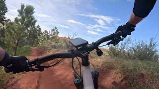
This extension to the Nomad trail offers a more interesting singletrack approach to the Towers Road from the Soderberg trail head than the wide gravel Swan Johnson Trail. The trail meanders across the hillside and crosses some drainages. The climb is not steep and there are few, if any technical parts. Sight lines are pretty good overall, but there are a few blind corners on which cyclists should use caution. As will the rest of Horsetooth, eBikes are currently prohibited on this trail.

Access Info

Parking at Soderberg trail head.

Local Trail Association

Recent Activity on Trail

Past Week
  • 8 rides
  • 11 miles average
6 Months
  • 192 rides
  • 11 miles avg distance
All
  • 1,049 rides
  • Last: Jun 19, 2026
c1c2c3c4
January
February
March
April
May
June
July
August
September
October
November
December
update trails status or condition

Nomad South Trail Reports

Status:
on Aug 15, 2025
Very Dry
Avg: 4.11 (2 votes)
Your vote: 0

view (6,147)
close
3D
Trail Conditions
  • Unknown
  • Snow Groomed
  • Snow Packed
  • Snow Covered
  • Snow Cover Partial
  • Freeze/thaw Cycle
  • Icy
  • Prevalent Mud
  • Wet
  • Variable
  • Ideal
  • Dry
  • Very Dry
Trail Flow (Ridden Direction)
Trailforks scans users ridelogs to determine the most popular direction each trail is ridden. A good flowing trail network will have most trails flowing in a single direction according to their intension.
The colour categories are based on what percentage of riders are riding a trail in its intended direction.
  • > 96%
  • > 90%
  • > 80%
  • > 70%
  • > 50%
  • < 50%
  • bi-directional trail
  • no data
Trail Last Ridden
Trailforks scans ridelogs to determine the last time a trail was ridden.
  • < 2 days
  • < 1 week
  • < 2 weeks
  • < 1 month
  • < 6 months
  • > 6 months
Trail Ridden Direction
The intended direction a trail should be ridden.
  • Downhill Only
  • Downhill Primary
  • Both Directions
  • Uphill Primary
  • Uphill Only
  • One Direction
Contribute Details
Colors indicate trail is missing specified detail.
  • Description
  • Photos
  • Description & Photos
  • Videos
Trail Popularity ?
Trailforks scans ridelogs to determine which trails are ridden the most in the last 9 months. Trails are compared with nearby trails in the same city region with a possible 25 colour shades. Think of this as a heatmap, more rides = more kinetic energy = warmer colors.
  • most popular
  • popular
  • less popular
  • not popular
ATV/ORV/OHV Filter
Max Vehicle Width
inches
US Cell Coverage
Legend
cell carrier legend

Radar Time
Activity Recordings
Trailforks uses anonymized public activity data. ?
Activity Recordings
Trailforks uses anonymized public activity data. ?
Personal Heatmap
Activity Types
all / none
Options
2
Date range month
Winter Trails
Warning A routing network for winter maps does not exist. Selecting trails using the winter trails layer has been disabled.
Missing Trails
Most Popular
Least Popular
Trails are colored based on popularity. The more popular a trail is, the more red. Less popular trails trend towards green.
Jump Magnitude Heatmap
Heatmap of where riders jump on trails. Zoom in to see individual jumps, click circles to view jump details.
BC Backroad Status

Service Road Atlas is a free to use, community-driven service for viewing and creating reports on the numerous back-country service roads around B.C. and Alberta.

map legend
Slope Aspect
Direction the slope faces
Flat N NE E SE S SW W NW
Trails Deemphasized
Trails are shown in grey.
disable
Only show trails with no bike usage.
Enable
Suggested Layers
Based on selected activity type

    Save the current map location and zoom level as your default home location whenever this page is loaded.

    Save
        Directions to nomad-south trailhead (40.532260, -105.163240)

        Photos

        No photos have been added for Nomad South yet, add a photo.

        Videos

        1 more »
        Nomad South - Horsetooth Mountain - Fort...
        2:22 | 111 | May 12, 2024 , Fort Collins

        Routes with this trail

        8 miles 1,470 ft 6 Loop
        If Maxwell is too short for you or you're just getting bit tired of it, this is your next step up....

        Trail Products

        Reviews / Comments

        No reviews yet, be the first to write a review or ask a question.
        Use trail reports to comment on trail conditions.


        We hope you've been enjoying Trailforks!

        Create a FREE account to view trail comments and much more.

        • By sgltrak & contributors
        • #582687 - 688 views

        Frequently Asked Questions About Nomad South

        Where is Nomad South located?
        Nomad South is located in Horsetooth Mountain, Fort Collins, Colorado, United States. It is part of the Horsetooth Mountain trail network. The trailhead is located at coordinates 40.53226, -105.16324.
        How hard is Nomad South?
        Nomad South is rated as Green difficulty. The physical rating is Easy. The average grade is 3.1%. The climb difficulty is rated Green.
        What is the elevation gain for Nomad South?
        Nomad South has 117 ft of elevation gain. The trail has 18 ft of elevation descent. The elevation ranges from 5,471 ft to 5,577 ft.
        Is Nomad South a point to point trail?
        Nomad South is not a point to point trail. The direction is Both Directions. The trail type is singletrack.

        Hit the Trail

        Open in App

        Get this trail on your phone instantly.
        open trail in app

        Download Trail

        Save to wishlist, Garmin & download.
        save the trail

        Find Related Routes

        Find routes and users activities that include this trail.
        find routes for this trail

        You must enter a description before submitting.