more stats
3.6 miles
Distance
-1,923 ft
Descent
00:30:10
Avg time
-1,923 ft
Altitude change
1,835 ft
Altitude min
3,757 ft
Altitude max
3,757 ft
Altitude start
1,834 ft
Altitude end
-10.2%
Grade
-53.3%
Grade max
3.5%
Grade min
102 ft
Distance climb
3 miles
Distance down
410 ft
Distance flat
00:30:10
Avg time

North Ridge Details

  • Activities
    • Mountain Bike
    • Hike
    • Trail Running
  • Riding Area
    Marys Peak
    Philomath, Oregon
  • Difficulty Rating
  • Voted Difficulty
    Black Diamond (1 vote)
  • Local Popularity
    95 in Mountain Biking [+]
    • 100 in Trail Running
    • 75 in Hiking
  • Global Ranking
    #31701 in Mountain Biking [+]
    • #472 in Trail Running
    • #38428 in Hiking
  • Trail Type
    Singletrack
  • Bike Type
    AM, XC
  • Direction
    Downhill Primary
    Popular Direction Shown
  • Climb Difficulty
    Black Diamond
  • Physical Rating
    Hard
  • Season
    May 1 - October 1
  • Dogs Allowed
    Yes
  • Land Owner

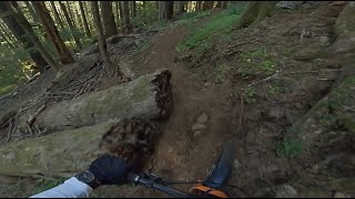
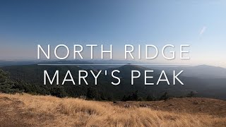
Old-school bench-cut multiuse singletrack that descends off the Marys Peak paved lot down to the gate at Woods Creek Rd. Lots of sidehill exposure, tight switchbacks, roots, and deadfall. Open to bikes from late spring through early fall. Many technical features and dynamic changes to the trail every year due to the exposure atop this peak to winter storms, snow, and falling trees.

Disclaimer

Not Suitable for Adaptive

Trail Supporters

  • USFS
    Land Manager
Local Trail Association
Traditionally Indigenous Territory

Recent Activity on Trail

Past Week
  • 0 rides
  •  
6 Months
  • 3 rides
  • 10 miles avg distance
All
  • 104 rides
  • Last: Sep 18, 2022
c1c2c3c4
January
February
March
April
May
June
July
August
September
October
November
December
update trails status or condition

North Ridge Trail Reports

statusdatedescription
May 15, 2026 @ 11:02am (America/Los_Angeles)
May 15, 2026
Open to bikes until October 15th, 2026.
Nov 3, 2025 @ 3:19pm (America/Los_Angeles)
Nov 3, 2025
No bikes allowed on trails October 16th, 2025 through May 14th, 2026. Trails will reopen to bikes on May 15th, 2026.
Nov 1, 2025 @ 1:50pm (America/Los_Angeles)
Nov 1, 2025
Closed to bikes from October 16, 2025 to May 14, 2026. Trail will reopen to bikes on May 15, 2026.
Aug 30, 2025 @ 8:58am
Aug 30, 2025
A little dusty, but overall running good!
Aug 2, 2025 @ 8:09pm
Aug 2, 2025
more »
Status:
on May 15, 2026
Variable
Avg: 4.52 (13 votes)
Your vote: 0

view (925)
close
3D
Trail Conditions
  • Unknown
  • Snow Groomed
  • Snow Packed
  • Snow Covered
  • Snow Cover Partial
  • Freeze/thaw Cycle
  • Icy
  • Prevalent Mud
  • Wet
  • Variable
  • Ideal
  • Dry
  • Very Dry
Trail Flow (Ridden Direction)
Trailforks scans users ridelogs to determine the most popular direction each trail is ridden. A good flowing trail network will have most trails flowing in a single direction according to their intension.
The colour categories are based on what percentage of riders are riding a trail in its intended direction.
  • > 96%
  • > 90%
  • > 80%
  • > 70%
  • > 50%
  • < 50%
  • bi-directional trail
  • no data
Trail Last Ridden
Trailforks scans ridelogs to determine the last time a trail was ridden.
  • < 2 days
  • < 1 week
  • < 2 weeks
  • < 1 month
  • < 6 months
  • > 6 months
Trail Ridden Direction
The intended direction a trail should be ridden.
  • Downhill Only
  • Downhill Primary
  • Both Directions
  • Uphill Primary
  • Uphill Only
  • One Direction
Contribute Details
Colors indicate trail is missing specified detail.
  • Description
  • Photos
  • Description & Photos
  • Videos
Trail Popularity ?
Trailforks scans ridelogs to determine which trails are ridden the most in the last 9 months. Trails are compared with nearby trails in the same city region with a possible 25 colour shades. Think of this as a heatmap, more rides = more kinetic energy = warmer colors.
  • most popular
  • popular
  • less popular
  • not popular
ATV/ORV/OHV Filter
Max Vehicle Width
inches
US Cell Coverage
Legend
cell carrier legend

Radar Time
Activity Recordings
Trailforks uses anonymized public activity data. ?
Activity Recordings
Trailforks uses anonymized public activity data. ?
Personal Heatmap
Activity Types
all / none
Options
2
Date range month
Winter Trails
Warning A routing network for winter maps does not exist. Selecting trails using the winter trails layer has been disabled.
Missing Trails
Most Popular
Least Popular
Trails are colored based on popularity. The more popular a trail is, the more red. Less popular trails trend towards green.
Jump Magnitude Heatmap
Heatmap of where riders jump on trails. Zoom in to see individual jumps, click circles to view jump details.
BC Backroad Status

Service Road Atlas is a free to use, community-driven service for viewing and creating reports on the numerous back-country service roads around B.C. and Alberta.

map legend
Slope Aspect
Direction the slope faces
Flat N NE E SE S SW W NW
Trails Deemphasized
Trails are shown in grey.
disable
Only show trails with no bike usage.
Enable
Suggested Layers
Based on selected activity type

    Save the current map location and zoom level as your default home location whenever this page is loaded.

    Save
        Directions to north-ridge trailhead (44.510840, -123.550570)

        Photos

        7 more »
        209 |
        Jul 15, 2023 @ 4:30am
        Jul 15, 2023
        186 |
        Jul 15, 2023 @ 4:30am
        Jul 15, 2023
        194 |
        Jul 15, 2023 @ 4:30am
        Jul 15, 2023
        441 |
        Jul 1, 2019 @ 7:41pm
        Jul 1, 2019

        Videos

        4 more »
        North ridge DH  |  Mary's peak
        8:59 | 350 | Oct 23, 2023 , Philomath
        North Ridge - Mary's Peak - Corvallis, Oregon
        23:48 | 674 | Mar 31, 2022 , Philomath
        Oregon Mountain biker, Mushroom Man Matthias...
        0:42 | 231 | Dec 14, 2021 , Philomath
        North Ridge DH Trail || Mary's Peak Philomath,...
        8:30 | 460 | Dec 14, 2021 , Philomath

        Routes with this trail

        4.2 9 miles 2,050 ft 2 Loop
        Park at end of Woods Creek Road. Go around the gate and start climbing (50ft in, off to your right you...

        6 Reviews & Comments


        We hope you've been enjoying Trailforks!

        Create a FREE account to view trail comments and much more.

        • By thomgirod & contributors
        • #29437 - 4,780 views

        Frequently Asked Questions About North Ridge

        Where is North Ridge located?
        North Ridge is located in Marys Peak, Philomath, Oregon, United States. It is part of the Marys Peak trail network. The trailhead is located at coordinates 44.51084, -123.55057.
        How hard is North Ridge?
        North Ridge is rated as Black Diamond difficulty. The physical rating is Hard. The average grade is 10.2%. The climb difficulty is rated Black Diamond.
        What is the elevation gain for North Ridge?
        The trail has 1,923 ft of elevation descent. The elevation ranges from 1,835 ft to 3,757 ft.
        Is North Ridge a point to point trail?
        North Ridge is not a point to point trail. The direction is Downhill Primary. The trail type is singletrack.

        Hit the Trail

        Open in App

        Get this trail on your phone instantly.
        open trail in app

        Download Trail

        Save to wishlist, Garmin & download.
        save the trail

        Find Related Routes

        Find routes and users activities that include this trail.
        find routes for this trail

        You must enter a description before submitting.