more stats
1.4 miles
Distance
156 ft
Climb
-181 ft
Descent
00:14:53
Avg time
-25 ft
Altitude change
1,102 ft
Altitude min
1,212 ft
Altitude max
1,135 ft
Altitude start
1,109 ft
Altitude end
-0.3%
Grade
-17.6%
Grade max
15.6%
Grade min
2,467 ft
Distance climb
3,012 ft
Distance down
1,693 ft
Distance flat
00:14:53
Avg time

Trail Details

  • Activities
    • Mountain Bike
    • E-Bike
    • Hike
    • Trail Running
  • Riding Area
    Blowing Springs
    Bella Vista, Arkansas
  • Difficulty Rating
  • Voted Difficulty
    Blue (1 vote)
  • Local Popularity
    85 in Mountain Biking [+]
    • 75 in E-Biking
    • 95 in Trail Running
    • 90 in Hiking
  • Global Ranking
    #2953 in Mountain Biking [+]
    • #2819 in E-Biking
    • #34441 in Trail Running
    • #46486 in Hiking
  • Hiking SAC Scale
    T3 Demanding Mountain Hiking
  • Trail Type
    Singletrack
  • Bike Type
    AM, XC
  • Direction
    Both Directions
    Popular Direction Shown
  • Climb Difficulty
    Black Diamond
  • Physical Rating
    Moderate
  • Dogs Allowed
    Yes
  • eBike Allowed
    Yes up to Class 1

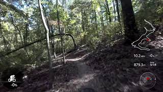
The north side of the Blowing Springs Loop is a black diamond trail due to the technical rock and roots. This side of Blowing Spring loop connects to the Back 40 as well as Bomb Diggity.

Local Trail Association

Recent Activity on Trail

Past Week
  • 2 rides
  • 9 miles average
6 Months
  • 171 rides
  • 17 miles avg distance
All
  • 882 rides
  • Last: Jun 17, 2026
c1c2c3c4
January
February
March
April
May
June
July
August
September
October
November
December
update trails status or condition

Blowing Springs... Trail Reports

statusdatedescription
Apr 18, 2026 @ 11:05am (America/Chicago)
Apr 18, 2026
Apr 13, 2026 @ 3:50pm (America/Chicago)
Apr 13, 2026
Medium size downed tree
Mar 30, 2026 @ 6:55am (America/Chicago)
Mar 30, 2026
Here’s a 15 foot section of trail covered with some debris that a section Volunteer should get off before the next big rain. there are about 6...
Mar 11, 2026 @ 6:30am (America/Chicago)
Mar 11, 2026
There is an old road above the trail that is entrenched and forming a new creek. The damage to the trail is minor and fun to ride. But this is not...
Nov 11, 2025 @ 9:15pm (America/Chicago)
Nov 11, 2025
Widowmaker
more » 2 social media mentions
Status:
on Apr 18, 2026
Avg: 4.5 (16 votes)
Your vote: 0

view (7,057)
close
3D
Trail Conditions
  • Unknown
  • Snow Groomed
  • Snow Packed
  • Snow Covered
  • Snow Cover Partial
  • Freeze/thaw Cycle
  • Icy
  • Prevalent Mud
  • Wet
  • Variable
  • Ideal
  • Dry
  • Very Dry
Trail Flow (Ridden Direction)
Trailforks scans users ridelogs to determine the most popular direction each trail is ridden. A good flowing trail network will have most trails flowing in a single direction according to their intension.
The colour categories are based on what percentage of riders are riding a trail in its intended direction.
  • > 96%
  • > 90%
  • > 80%
  • > 70%
  • > 50%
  • < 50%
  • bi-directional trail
  • no data
Trail Last Ridden
Trailforks scans ridelogs to determine the last time a trail was ridden.
  • < 2 days
  • < 1 week
  • < 2 weeks
  • < 1 month
  • < 6 months
  • > 6 months
Trail Ridden Direction
The intended direction a trail should be ridden.
  • Downhill Only
  • Downhill Primary
  • Both Directions
  • Uphill Primary
  • Uphill Only
  • One Direction
Contribute Details
Colors indicate trail is missing specified detail.
  • Description
  • Photos
  • Description & Photos
  • Videos
Trail Popularity ?
Trailforks scans ridelogs to determine which trails are ridden the most in the last 9 months. Trails are compared with nearby trails in the same city region with a possible 25 colour shades. Think of this as a heatmap, more rides = more kinetic energy = warmer colors.
  • most popular
  • popular
  • less popular
  • not popular
ATV/ORV/OHV Filter
Max Vehicle Width
inches
US Cell Coverage
Legend
cell carrier legend

Radar Time
Activity Recordings
Trailforks uses anonymized public activity data. ?
Activity Recordings
Trailforks uses anonymized public activity data. ?
Personal Heatmap
Activity Types
all / none
Options
2
Date range month
Winter Trails
Warning A routing network for winter maps does not exist. Selecting trails using the winter trails layer has been disabled.
Missing Trails
Most Popular
Least Popular
Trails are colored based on popularity. The more popular a trail is, the more red. Less popular trails trend towards green.
Jump Magnitude Heatmap
Heatmap of where riders jump on trails. Zoom in to see individual jumps, click circles to view jump details.
BC Backroad Status

Service Road Atlas is a free to use, community-driven service for viewing and creating reports on the numerous back-country service roads around B.C. and Alberta.

map legend
Slope Aspect
Direction the slope faces
Flat N NE E SE S SW W NW
Trails Deemphasized
Trails are shown in grey.
disable
Only show trails with no bike usage.
Enable
Suggested Layers
Based on selected activity type

    Save the current map location and zoom level as your default home location whenever this page is loaded.

    Save
        Directions to blowing-springs-loop-north trailhead (36.447260, -94.219500)

        Photos

        11 more »
        820 |
        Dec 1, 2017 @ 4:27pm
        Dec 1, 2017
        892 |
        Dec 1, 2017 @ 4:15pm
        Dec 1, 2017
        452 |
        Aug 5, 2020 @ 11:05am
        Aug 5, 2020
        586 |
        May 17, 2019 @ 9:27am
        May 17, 2019

        Videos

        6 more »
        Blowing Springs Loop | Full Trail, Mountain...
        14:37 | 652 | Sep 20, 2022 , Bella Vista
        youtuber Getting lost on the Back40 | Finding Blowing...
        13:28 | 628 | Jun 2, 2022 , Bella Vista
        Blowing Springs Park
        26:52 | 557 | Oct 4, 2020 , Bella Vista
        Oz Trails 'AREA 51' Mad Hatter Jump Trail -...
        0:00 | 596 | Jan 16, 2021 , Bella Vista

        Routes with this trail

        12 miles 1,305 ft 3
        A fun, moderately techy loop in the Back 40
        15 miles 1,383 ft 5
        Obermeyer vwigrhioenanofihgerngrnaegiJ
        35 miles 2,516 ft 22 Loop
        oz trail off road recon ....................................................................

        3 Reviews & Comments


        We hope you've been enjoying Trailforks!

        Create a FREE account to view trail comments and much more.

        Frequently Asked Questions About Blowing Springs Loop (North)

        Where is Blowing Springs Loop (North) located?
        Blowing Springs Loop (North) is located in Blowing Springs, Bella Vista, Arkansas, United States. It is part of the Blowing Springs trail network. The trailhead is located at coordinates 36.44726, -94.2195.
        How hard is Blowing Springs Loop (North)?
        Blowing Springs Loop (North) is rated as Blue difficulty. The physical rating is Moderate. The average grade is 0.3%. The climb difficulty is rated Black Diamond.
        What is the elevation gain for Blowing Springs Loop (North)?
        Blowing Springs Loop (North) has 156 ft of elevation gain. The trail has 181 ft of elevation descent. The elevation ranges from 1,102 ft to 1,212 ft.
        Is Blowing Springs Loop (North) a point to point trail?
        Blowing Springs Loop (North) is not a point to point trail. The direction is Both Directions. The trail type is singletrack.

        Hit the Trail

        Open in App

        Get this trail on your phone instantly.
        open trail in app

        Download Trail

        Save to wishlist, Garmin & download.
        save the trail

        Find Related Routes

        Find routes and users activities that include this trail.
        find routes for this trail

        You must enter a description before submitting.