more stats
2,444 ft
Distance
75 ft
Climb
-179 ft
Descent
00:08:58
Avg time
-104 ft
Altitude change
641 ft
Altitude min
817 ft
Altitude max
817 ft
Altitude start
712 ft
Altitude end
-4.3%
Grade
-45.2%
Grade max
16.7%
Grade min
1,007 ft
Distance climb
1,368 ft
Distance down
69 ft
Distance flat
00:08:58
Avg time

Northern Monkey Details

  • Activities
    • Mountain Bike
    • E-Bike
  • Riding Area
    Surrey Hills
    Dorking
  • Difficulty Rating
  • Voted Difficulty
    Red (1 vote)
  • Local Popularity
    85 in Mountain Biking [+]
    • 90 in E-Biking
  • Global Ranking
    #10215 in Mountain Biking [+]
    • #1896 in E-Biking
  • Trail Type
    Singletrack
  • Bike Type
    DH, AM
  • Direction
    Downhill Primary
    Popular Direction Shown
  • Physical Rating
    Moderate
  • Dogs Allowed
    Yes
  • eBike Allowed
    Yes up to Class 1
  • TTFs on Trail
    Drop, Jump, Gap Jump

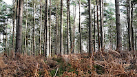
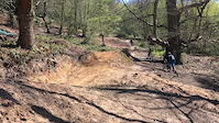
The start is to the right of a large tree. Follow the trail down and take a tight left with a small drop on the corner, Just after the optional wall ride style mud bank there is a tight right and the trail splits. If its your first time take the right line as the jumps on the left line get big quite quickly.

This trail is unsanctioned.

Recent Activity on Trail

Past Week
  • 0 rides
  •  
6 Months
  • 47 rides
  • 14 miles avg distance
All
  • 555 rides
  • Last: Jun 14, 2026
c1c2c3c4
January
February
March
April
May
June
July
August
September
October
November
December
update trails status or condition

Northern Monkey Trail Reports

statusdatedescription
Mar 21, 2026 @ 8:15am (Europe/London)
Mar 21, 2026
Trail ran really well today
Sep 29, 2025 @ 10:51am (Europe/London)
Sep 29, 2025
Great condition, large jumps at the bottom have been bulldozed away, RH line with small jumps ok.
Jul 7, 2025 @ 12:05pm
Jul 7, 2025
Running great, stay right to avoid the gap jumps
Jun 11, 2025 @ 11:27am
Jun 11, 2025
May 3, 2025 @ 10:40am
May 3, 2025
more »
Status:
on Mar 21, 2026
Ideal
Avg: 4.24 (10 votes)
Your vote: 0

view (6,678)
close
3D
Trail Conditions
  • Unknown
  • Snow Groomed
  • Snow Packed
  • Snow Covered
  • Snow Cover Partial
  • Freeze/thaw Cycle
  • Icy
  • Prevalent Mud
  • Wet
  • Variable
  • Ideal
  • Dry
  • Very Dry
Trail Flow (Ridden Direction)
Trailforks scans users ridelogs to determine the most popular direction each trail is ridden. A good flowing trail network will have most trails flowing in a single direction according to their intension.
The colour categories are based on what percentage of riders are riding a trail in its intended direction.
  • > 96%
  • > 90%
  • > 80%
  • > 70%
  • > 50%
  • < 50%
  • bi-directional trail
  • no data
Trail Last Ridden
Trailforks scans ridelogs to determine the last time a trail was ridden.
  • < 2 days
  • < 1 week
  • < 2 weeks
  • < 1 month
  • < 6 months
  • > 6 months
Trail Ridden Direction
The intended direction a trail should be ridden.
  • Downhill Only
  • Downhill Primary
  • Both Directions
  • Uphill Primary
  • Uphill Only
  • One Direction
Contribute Details
Colors indicate trail is missing specified detail.
  • Description
  • Photos
  • Description & Photos
  • Videos
Trail Popularity ?
Trailforks scans ridelogs to determine which trails are ridden the most in the last 9 months. Trails are compared with nearby trails in the same city region with a possible 25 colour shades. Think of this as a heatmap, more rides = more kinetic energy = warmer colors.
  • most popular
  • popular
  • less popular
  • not popular
ATV/ORV/OHV Filter
Max Vehicle Width
inches
US Cell Coverage
Legend
cell carrier legend

Radar Time
Activity Recordings
Trailforks uses anonymized public activity data. ?
Activity Recordings
Trailforks uses anonymized public activity data. ?
Personal Heatmap
Activity Types
all / none
Options
2
Date range month
Winter Trails
Warning A routing network for winter maps does not exist. Selecting trails using the winter trails layer has been disabled.
Missing Trails
Most Popular
Least Popular
Trails are colored based on popularity. The more popular a trail is, the more red. Less popular trails trend towards green.
Jump Magnitude Heatmap
Heatmap of where riders jump on trails. Zoom in to see individual jumps, click circles to view jump details.
BC Backroad Status

Service Road Atlas is a free to use, community-driven service for viewing and creating reports on the numerous back-country service roads around B.C. and Alberta.

map legend
Slope Aspect
Direction the slope faces
Flat N NE E SE S SW W NW
Trails Deemphasized
Trails are shown in grey.
disable
Only show trails with no bike usage.
Enable
Suggested Layers
Based on selected activity type

    Save the current map location and zoom level as your default home location whenever this page is loaded.

    Save
        Directions to northern-monkey trailhead (51.170160, -0.468710)

        Photos

        46 more »
        711 |
        Feb 28, 2016 @ 1:31pm
        Feb 28, 2016
        838 |
        May 1, 2015 @ 8:42am
        May 1, 2015
        308 |
        Dec 31, 2021 @ 11:14am
        Dec 31, 2021
        214 |
        Oct 20, 2021 @ 1:25pm
        Oct 20, 2021

        Videos

        14 more »
        youtuber Peaslake Surrey Hills has some brilliant...
        19:30 | 843 | Sep 26, 2022 , Dorking
        Pitch Hill - Winter 2019
        3:05 | 908 | Feb 12, 2019 , Dorking
        Northern Monkey 3/5
        0:33 | 935 | Jul 26, 2018 , Dorking
        Brother crashing hard on Northern Monkey...
        0:16 | 3634 | Apr 12, 2017 , Dorking

        5 Reviews & Comments


        We hope you've been enjoying Trailforks!

        Create a FREE account to view trail comments and much more.

        Nearby Trails

        • #35127 - 20,138 views

        Frequently Asked Questions About Northern Monkey

        Where is Northern Monkey located?
        Northern Monkey is located in Surrey Hills, Dorking, United Kingdom. It is part of the Surrey Hills trail network. The trailhead is located at coordinates 51.17016, -0.46871.
        How hard is Northern Monkey?
        Northern Monkey is rated as Black difficulty. The physical rating is Moderate. The average grade is 4.3%.
        What is the elevation gain for Northern Monkey?
        Northern Monkey has 23 m of elevation gain. The trail has 55 m of elevation descent. The elevation ranges from 196 m to 249 m.
        Is Northern Monkey a point to point trail?
        Northern Monkey is not a point to point trail. The direction is Downhill Primary. The trail type is singletrack.

        Hit the Trail

        Open in App

        Get this trail on your phone instantly.
        open trail in app

        Download Trail

        Save to wishlist, Garmin & download.
        save the trail

        Find Related Routes

        Find routes and users activities that include this trail.
        find routes for this trail

        You must enter a description before submitting.