more stats
3.6 miles
Distance
2,787 ft
Climb
-225 ft
Descent
2 miles
High Point
2,563 ft
Altitude change
6,888 ft
Altitude min
6,888 ft
Altitude start
9,452 ft
Altitude end
13.4%
Grade
-100.3%
Grade max
152.3%
Grade min
3 miles
Distance climb
1,138 ft
Distance down
384 ft
Distance flat

Notch Peak Details

  • Activities
    • Hike
    • Trail Running
  • Riding Area
    Fillmore
    , Utah
  • Difficulty Rating
  • Local Popularity
    100 in Hiking [+]
    • 5 in Trail Running
  • Global Ranking
    #18 in Hiking [+]
    • #137820 in Trail Running
  • Hiking SAC Scale
    T3 Demanding Mountain Hiking
  • Trail Type
    Singletrack
  • Direction
    Both Directions
  • Trail Visibility
    Sometimes hard to follow
  • Dogs Allowed
    Yes
  • eBike Allowed

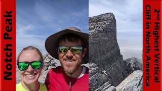
Sawtooth Canyon trailhead to the summit of Notch Peak. Very remote and dry trail, which can be very hot in the summer, so be prepared Most of the trail is pretty easy until you get to the big waterfall, then it get's more technical and steep from there. Absolutely spectacular landscape and views! Notch Peak is the hightest limestone cliff in North America and the second highest sheer cliff in the North America.

Traditionally Indigenous Territory

Recent Activity on Trail

Past Week
  • 0 rides
  •  
6 Months
  • 1 rides
  • 11 miles avg distance
All
  • 5 rides
  •  
c1c2c3c4
January
February
March
April
May
June
July
August
September
October
November
December
update trails status or condition

Notch Peak Trail Reports

statusdatedescription
Sep 24, 2022 @ 6:34am
Sep 24, 2022
more »
Status:
on Sep 24, 2022
Dry
Avg: 4.01 (1 votes)
Your vote: 0

view (47)
close
3D
Trail Conditions
  • Unknown
  • Snow Groomed
  • Snow Packed
  • Snow Covered
  • Snow Cover Partial
  • Freeze/thaw Cycle
  • Icy
  • Prevalent Mud
  • Wet
  • Variable
  • Ideal
  • Dry
  • Very Dry
Trail Flow (Ridden Direction)
Trailforks scans users ridelogs to determine the most popular direction each trail is ridden. A good flowing trail network will have most trails flowing in a single direction according to their intension.
The colour categories are based on what percentage of riders are riding a trail in its intended direction.
  • > 96%
  • > 90%
  • > 80%
  • > 70%
  • > 50%
  • < 50%
  • bi-directional trail
  • no data
Trail Last Ridden
Trailforks scans ridelogs to determine the last time a trail was ridden.
  • < 2 days
  • < 1 week
  • < 2 weeks
  • < 1 month
  • < 6 months
  • > 6 months
Trail Ridden Direction
The intended direction a trail should be ridden.
  • Downhill Only
  • Downhill Primary
  • Both Directions
  • Uphill Primary
  • Uphill Only
  • One Direction
Contribute Details
Colors indicate trail is missing specified detail.
  • Description
  • Photos
  • Description & Photos
  • Videos
Trail Popularity ?
Trailforks scans ridelogs to determine which trails are ridden the most in the last 9 months. Trails are compared with nearby trails in the same city region with a possible 25 colour shades. Think of this as a heatmap, more rides = more kinetic energy = warmer colors.
  • most popular
  • popular
  • less popular
  • not popular
ATV/ORV/OHV Filter
Max Vehicle Width
inches
US Cell Coverage
Legend
cell carrier legend

Radar Time
Activity Recordings
Trailforks uses anonymized public activity data. ?
Activity Recordings
Trailforks uses anonymized public activity data. ?
Personal Heatmap
Activity Types
all / none
Options
2
Date range month
Winter Trails
Warning A routing network for winter maps does not exist. Selecting trails using the winter trails layer has been disabled.
Missing Trails
Most Popular
Least Popular
Trails are colored based on popularity. The more popular a trail is, the more red. Less popular trails trend towards green.
Jump Magnitude Heatmap
Heatmap of where riders jump on trails. Zoom in to see individual jumps, click circles to view jump details.
BC Backroad Status

Service Road Atlas is a free to use, community-driven service for viewing and creating reports on the numerous back-country service roads around B.C. and Alberta.

map legend
Slope Aspect
Direction the slope faces
Flat N NE E SE S SW W NW
Trails Deemphasized
Trails are shown in grey.
disable
Only show trails with no bike usage.
Enable
Suggested Layers
Based on selected activity type

    Save the current map location and zoom level as your default home location whenever this page is loaded.

    Save
        Directions to notch-peak trailhead (39.127920, -113.363820)

        Photos

        25 more »
        45 |
        Sep 12, 2022 @ 11:32am
        Sep 12, 2022
        26 |
        Sep 12, 2022 @ 11:32am
        Sep 12, 2022
        37 |
        Sep 12, 2022 @ 11:32am
        Sep 12, 2022
        45 |
        Sep 12, 2022 @ 11:32am
        Sep 12, 2022

        Videos

        1 more »
        youtuber Hiking Notch Peak (Second Highest Sheer Cliff...
        21:14 | 184 | Sep 12, 2022 , Fillmore

        1 Review & Comments


        We hope you've been enjoying Trailforks!

        Create a FREE account to view trail comments and much more.

        • By minerbikerTF Pro & contributors
        • #568544 - 897 views

        Frequently Asked Questions About Notch Peak

        Where is Notch Peak located?
        Notch Peak is located in Fillmore, Utah, United States. It is part of the Fillmore trail network. The trailhead is located at coordinates 39.12792, -113.36382.
        How hard is Notch Peak?
        Notch Peak is rated as Black Diamond difficulty. The average grade is 13.4%.
        What is the elevation gain for Notch Peak?
        Notch Peak has 2,787 ft of elevation gain. The trail has 225 ft of elevation descent. The elevation ranges from 6,888 ft to 9,451 ft.
        Is Notch Peak a point to point trail?
        Notch Peak is not a point to point trail. The direction is Both Directions. The trail type is singletrack.

        Hit the Trail

        Open in App

        Get this trail on your phone instantly.
        open trail in app

        Download Trail

        Save to wishlist, Garmin & download.
        save the trail

        Find Related Routes

        Find routes and users activities that include this trail.
        find routes for this trail

        You must enter a description before submitting.