more stats
3.7 miles
Distance
300 ft
Climb
-344 ft
Descent
00:26:45
Avg time
-45 ft
Altitude change
364 ft
Altitude min
491 ft
Altitude max
413 ft
Altitude start
367 ft
Altitude end
-0.2%
Grade
-15.6%
Grade max
18.4%
Grade min
1 mile
Distance climb
1 mile
Distance down
5,069 ft
Distance flat
00:26:45
Avg time

Nova Details

  • Activities
    • Mountain Bike
  • Riding Area
    Ashton Court
    Bristol
  • AKA
    blue trail
  • Difficulty Rating
  • Voted Difficulty
    Blue (3 votes)
  • Local Popularity
    95 in Mountain Biking
  • Global Ranking
    #37279 in Mountain Biking
  • Trail Type
    Singletrack
  • Bike Type
    AM, XC
  • Direction
    Downhill Only
    Popular Direction Shown
  • Physical Rating
    Moderate
  • Season
    All
  • Dogs Allowed
    Yes
  • eBike Allowed
    Yes up to Class 1
  • Ride in Rain
    Yes
  • Land Owner

BLUE GRADE (Moderate)
6.5KM (4 MILES) 0.75 - 1 HRS
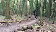
Ashton Court is a very busy multi-user site, and the Nova cycle trail crosses and shares
walking and horse riding routes. Expect the unexpected and respect pedestrians and horse
riders. Warn others of your approach in plenty of time and stop for horses if necessary. A
‘moderate’ Blue grade trail, the route offers a rewarding experience for relative novices and
more experienced riders. The Nova Trail winds around Ashton Court Estate, packing in non
stop flowing enjoyment along the way. The trail has small rock steps, rollers (bumps) and
berms (banked corners). In places the trail splits for a short distance, giving an option of a
more difficult challenge.

Access Info

Entry to Ashton Court via the archway at the top of Bridge Road. Continue along the road, past the gate and up the gravel track on the right. Trail starts at the top of the hill in the woods on the left.

Local Trail Association

Recent Activity on Trail

Past Week
  • 1 rides
  • 18 miles average
6 Months
  • 35 rides
  • 14 miles avg distance
All
  • 142 rides
  • Last: Jun 22, 2026
c1c2c3c4
January
February
March
April
May
June
July
August
September
October
November
December
update trails status or condition

Nova Trail Reports

statusdatedescription
Jul 20, 2025 @ 4:39pm
Jul 20, 2025
Dec 24, 2024 @ 2:46am
Dec 24, 2024
Very tame i found, great for beginners a couple of separate red routes you can take, if you like DH this is not for you.
Apr 9, 2023 @ 9:53am
Apr 9, 2023
all good
Apr 23, 2022 @ 7:19am
Apr 23, 2022
Feb 22, 2022 @ 1:58am
Feb 22, 2022
Tree down blocking split section near Beggar Bush lane, otherwise clear
more »
Status:
on Jul 20, 2025
Ideal
Avg: 3.95 (14 votes)
Your vote: 0

view (2,565)
close
3D
Trail Conditions
  • Unknown
  • Snow Groomed
  • Snow Packed
  • Snow Covered
  • Snow Cover Partial
  • Freeze/thaw Cycle
  • Icy
  • Prevalent Mud
  • Wet
  • Variable
  • Ideal
  • Dry
  • Very Dry
Trail Flow (Ridden Direction)
Trailforks scans users ridelogs to determine the most popular direction each trail is ridden. A good flowing trail network will have most trails flowing in a single direction according to their intension.
The colour categories are based on what percentage of riders are riding a trail in its intended direction.
  • > 96%
  • > 90%
  • > 80%
  • > 70%
  • > 50%
  • < 50%
  • bi-directional trail
  • no data
Trail Last Ridden
Trailforks scans ridelogs to determine the last time a trail was ridden.
  • < 2 days
  • < 1 week
  • < 2 weeks
  • < 1 month
  • < 6 months
  • > 6 months
Trail Ridden Direction
The intended direction a trail should be ridden.
  • Downhill Only
  • Downhill Primary
  • Both Directions
  • Uphill Primary
  • Uphill Only
  • One Direction
Contribute Details
Colors indicate trail is missing specified detail.
  • Description
  • Photos
  • Description & Photos
  • Videos
Trail Popularity ?
Trailforks scans ridelogs to determine which trails are ridden the most in the last 9 months. Trails are compared with nearby trails in the same city region with a possible 25 colour shades. Think of this as a heatmap, more rides = more kinetic energy = warmer colors.
  • most popular
  • popular
  • less popular
  • not popular
ATV/ORV/OHV Filter
Max Vehicle Width
inches
US Cell Coverage
Legend
cell carrier legend

Radar Time
Activity Recordings
Trailforks uses anonymized public activity data. ?
Activity Recordings
Trailforks uses anonymized public activity data. ?
Personal Heatmap
Activity Types
all / none
Options
2
Date range month
Winter Trails
Warning A routing network for winter maps does not exist. Selecting trails using the winter trails layer has been disabled.
Missing Trails
Most Popular
Least Popular
Trails are colored based on popularity. The more popular a trail is, the more red. Less popular trails trend towards green.
Jump Magnitude Heatmap
Heatmap of where riders jump on trails. Zoom in to see individual jumps, click circles to view jump details.
BC Backroad Status

Service Road Atlas is a free to use, community-driven service for viewing and creating reports on the numerous back-country service roads around B.C. and Alberta.

map legend
Slope Aspect
Direction the slope faces
Flat N NE E SE S SW W NW
Trails Deemphasized
Trails are shown in grey.
disable
Only show trails with no bike usage.
Enable
Suggested Layers
Based on selected activity type

    Save the current map location and zoom level as your default home location whenever this page is loaded.

    Save
        Directions to nova-5422 trailhead (51.447780, -2.648500)

        Photos

        91 more »
        185 |
        May 14, 2020 @ 6:43am
        May 14, 2020
        285 |
        Apr 27, 2019 @ 11:22am
        Apr 27, 2019
        344 |
        Jan 24, 2016 @ 12:27pm
        Jan 24, 2016
        339 |
        Jan 24, 2016 @ 12:27pm
        Jan 24, 2016

        Videos

        5 more »
        Heavy berm slam at Ashton Court
        0:22 | 159 | Nov 19, 2021 , Bristol
        Oli Paton - Ashton Court, Bristol
        0:48 | 791 | Feb 14, 2018 , Bristol
        MTB with little cousin
        3:47 | 324 | Dec 23, 2016 , Bristol
        Ashton court
        3:04 | 362 | Dec 19, 2011 , Bristol

        Routes with this trail

        4.0 17 miles 1,467 ft 35 Loop
        A loop taking in the best of Bristol singletrack taking in the first half of Leigh Woods, down to , can...
        12 miles 1,076 ft 13
        Alternative version of 15 miler avoiding the very greasy picnic bench sections.
        11 miles 1,194 ft 14 Loop
        a 15 mile ish circular bristol route, leigh olds off piste very muddy and slippy in the wet!!

        4 Reviews & Comments


        We hope you've been enjoying Trailforks!

        Create a FREE account to view trail comments and much more.

        • By ryanme & contributors
        • #5422 - 9,291 views

        Frequently Asked Questions About Nova

        Where is Nova located?
        Nova is located in Ashton Court, Bristol, United Kingdom. It is part of the Ashton Court trail network. The trailhead is located at coordinates 51.44778, -2.6485.
        How hard is Nova?
        Nova is rated as Blue difficulty. The physical rating is Moderate. The average grade is 0.2%.
        What is the elevation gain for Nova?
        Nova has 300 ft of elevation gain. The trail has 344 ft of elevation descent. The elevation ranges from 364 ft to 491 ft.
        Is Nova a point to point trail?
        Yes, Nova is a point to point trail. The direction is Downhill Only. The trail type is singletrack.

        Hit the Trail

        Open in App

        Get this trail on your phone instantly.
        open trail in app

        Download Trail

        Save to wishlist, Garmin & download.
        save the trail

        Find Related Routes

        Find routes and users activities that include this trail.
        find routes for this trail

        You must enter a description before submitting.