more stats
15.3 miles
Distance
4,246 ft
Climb
-4,223 ft
Descent
04:49:32
Avg time
23 ft
Altitude change
1,301 ft
Altitude max
22 ft
Altitude start
46 ft
Altitude end
-89.2%
Grade max
77.3%
Grade min
7 miles
Distance climb
7 miles
Distance down
1 mile
Distance flat
04:49:32
Avg time

Nydia Track Details

  • Activities
    • Mountain Bike
    • Hike
    • Trail Running
  • Riding Area
  • Difficulty Rating
  • Local Popularity
    90 in Mountain Biking [+]
    • 5 in Trail Running
    • 5 in Hiking
  • Global Ranking
    #29238 in Mountain Biking [+]
    • #123659 in Trail Running
    • #117437 in Hiking
  • Hiking SAC Scale
    T3 Demanding Mountain Hiking
  • Trail Type
    Wilderness Trail
  • Bike Type
    AM, XC
  • Direction
    Both Directions
    Popular Direction Shown
  • Climb Difficulty
    Black Diamond
  • Physical Rating
    Hard
  • Trail Visibility
    Sometimes hard to follow
  • Dogs Allowed
    Yes
  • TTFs on Trail
    Rock Face, Rock Garden
  • Land Owner

Start at Opouri Saddle end and ride the Opouri Bridle Track for an extra bit of technical downhill, or head into Duncan Bay and start from there.

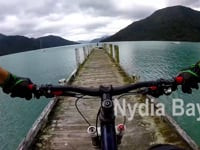
The track was once well benched, now taken over by nature and tree roots. Rocks and root riddles the track leading you over the Nydia Saddle at 370m and into Nydia Bay. You then head inland through farmland before heading over a second saddle, Kaiuma at 387m.

This is a technical ride which can take between 4-7 hours to ride. The track finishes on Kaiuma Bay Rd, 16km's from State Highway 6 and another 3km's to Havelock.

The trail works best from Duncan Bay to Kaiuma because if you are a good rider you can ride most uphill sections and down, the downs are more technical than the ups, so the other way would seem more of a hike-a-bike, although the descents more achievable.

Not recommended in the wet.

Access Info

From the Rai Valley township, cross the river and head 26km's northeast on Opouri Rd to Opouri Saddle (500m). Start here (see Opouri Bridle Track), or head down into Duncan Bay and start from there.

Secure free parking available at Kaiuma (the end of the track) when using the Pelorus Sound Water Taxi shuttle or car relocation option: www.pswt.co.nz
Larger groups can use the water taxi to the start of the track in Duncan Bay.

Blue Moon Lodge in Havelock can organise shuttles (http://www.bluemoonhavelock.co.nz/)

Local Trail Association

Recent Activity on Trail

Past Week
  • 0 rides
  •  
6 Months
  • 2 rides
  • 32 miles avg distance
All
  • 15 rides
  • Last: Mar 20, 2026
c1c2c3c4
January
February
March
April
May
June
July
August
September
October
November
December
update trails status or condition

Nydia Track Trail Reports

statusdatedescription
Feb 24, 2026 @ 8:16am (Pacific/Auckland)
Feb 23, 2026
A few trees down, but all can be clambered over/under. Slips are all passable, though not necessarily rideable. Long term erosion on low lines...
Nov 25, 2025 @ 10:06am (Pacific/Auckland)
Nov 24, 2025
Track now in good condition with just one new tree down on the Nydia side and a bit washed out at the bottom. The track has certainly deteriorated...
Sep 11, 2025 @ 2:13pm (America/Vancouver)
Sep 11, 2025
The track is in poor condition to my last ride here 5 years ago. There are a few slips that need work, trees down etc. Worth the mission, but be...
Mar 4, 2025 @ 12:35am
Mar 4, 2025
This trail is in very poor condition between Duncan Bay to Nydia Bay. You're lucky to be able to ride more than 1 minute at a time before getting...
Dec 23, 2024 @ 11:10am
Dec 23, 2024
The fallen tree is still there and it’s very hard to pass over it.
more »
Status:
on Feb 24, 2026
Ideal
Avg: 4.11 (14 votes)
Your vote: 0

view (172)
close
3D
Trail Conditions
  • Unknown
  • Snow Groomed
  • Snow Packed
  • Snow Covered
  • Snow Cover Partial
  • Freeze/thaw Cycle
  • Icy
  • Prevalent Mud
  • Wet
  • Variable
  • Ideal
  • Dry
  • Very Dry
Trail Flow (Ridden Direction)
Trailforks scans users ridelogs to determine the most popular direction each trail is ridden. A good flowing trail network will have most trails flowing in a single direction according to their intension.
The colour categories are based on what percentage of riders are riding a trail in its intended direction.
  • > 96%
  • > 90%
  • > 80%
  • > 70%
  • > 50%
  • < 50%
  • bi-directional trail
  • no data
Trail Last Ridden
Trailforks scans ridelogs to determine the last time a trail was ridden.
  • < 2 days
  • < 1 week
  • < 2 weeks
  • < 1 month
  • < 6 months
  • > 6 months
Trail Ridden Direction
The intended direction a trail should be ridden.
  • Downhill Only
  • Downhill Primary
  • Both Directions
  • Uphill Primary
  • Uphill Only
  • One Direction
Contribute Details
Colors indicate trail is missing specified detail.
  • Description
  • Photos
  • Description & Photos
  • Videos
Trail Popularity ?
Trailforks scans ridelogs to determine which trails are ridden the most in the last 9 months. Trails are compared with nearby trails in the same city region with a possible 25 colour shades. Think of this as a heatmap, more rides = more kinetic energy = warmer colors.
  • most popular
  • popular
  • less popular
  • not popular
ATV/ORV/OHV Filter
Max Vehicle Width
inches
US Cell Coverage
Legend
cell carrier legend

Radar Time
Activity Recordings
Trailforks uses anonymized public activity data. ?
Activity Recordings
Trailforks uses anonymized public activity data. ?
Personal Heatmap
Activity Types
all / none
Options
2
Date range month
Winter Trails
Warning A routing network for winter maps does not exist. Selecting trails using the winter trails layer has been disabled.
Missing Trails
Most Popular
Least Popular
Trails are colored based on popularity. The more popular a trail is, the more red. Less popular trails trend towards green.
Jump Magnitude Heatmap
Heatmap of where riders jump on trails. Zoom in to see individual jumps, click circles to view jump details.
BC Backroad Status

Service Road Atlas is a free to use, community-driven service for viewing and creating reports on the numerous back-country service roads around B.C. and Alberta.

map legend
Slope Aspect
Direction the slope faces
Flat N NE E SE S SW W NW
Trails Deemphasized
Trails are shown in grey.
disable
Only show trails with no bike usage.
Enable
Suggested Layers
Based on selected activity type

    Save the current map location and zoom level as your default home location whenever this page is loaded.

    Save
        Directions to nydia-track trailhead (-41.114700, 173.765540)

        Photos

        45 more »
        61 |
        Nov 23, 2024 @ 2:01am
        Nov 23, 2024
        103 |
        Jan 2, 2024 @ 9:22pm
        Jan 2, 2024
        94 |
        Jan 2, 2024 @ 9:22pm
        Jan 2, 2024
        116 |
        Jan 2, 2024 @ 9:22pm
        Jan 2, 2024

        Videos

        3 more »
        Nydia Bay Track 2015 - Marlborough Sounds...
        2:43 | 836 | Jan 22, 2020 , Duncan Bay
        Nydia Bay Tech
        13:22 | 1165 | Apr 17, 2019 , Duncan Bay
        Nydia Bay Track  - Biker vs Runner
        16:45 | 892 | May 6, 2018 , Duncan Bay

        9 Reviews & Comments


        We hope you've been enjoying Trailforks!

        Create a FREE account to view trail comments and much more.

        • By YogiNZ & contributors
        • #28457 - 19,471 views

        Frequently Asked Questions About Nydia Track

        Where is Nydia Track located?
        Nydia Track is located in Duncan Bay, New Zealand. It is part of the Duncan Bay trail network. The trailhead is located at coordinates -41.1147, 173.76554.
        How hard is Nydia Track?
        Nydia Track is rated as Black Diamond difficulty. The physical rating is Hard. The climb difficulty is rated Black Diamond.
        What is the elevation gain for Nydia Track?
        Nydia Track has 4,246 ft of elevation gain. The trail has 4,223 ft of elevation descent. The elevation ranges from 0 ft to 1,301 ft.
        Is Nydia Track a point to point trail?
        Nydia Track is not a point to point trail. The direction is Both Directions. The trail type is wilderness trail.

        Hit the Trail

        Open in App

        Get this trail on your phone instantly.
        open trail in app

        Download Trail

        Save to wishlist, Garmin & download.
        save the trail

        Find Related Routes

        Find routes and users activities that include this trail.
        find routes for this trail

        You must enter a description before submitting.