more stats
1.0 mile
Distance
2 ft
Climb
-1,216 ft
Descent
00:21:22
Avg time
-1,213 ft
Altitude change
3,256 ft
Altitude min
4,469 ft
Altitude max
4,469 ft
Altitude start
3,258 ft
Altitude end
-22.1%
Grade
-80.8%
Grade max
2%
Grade min
200 ft
Distance climb
1 mile
Distance down
00:21:22
Avg time

O Brot Details

  • Activities
    • Mountain Bike
    • E-Bike
    • Hike
    • Trail Running
  • Riding Area
    Saint-Lary Enduro
    Saint Lary Soulan
  • Ref Number
    #23
  • Difficulty Rating
  • Voted Difficulty
    Proline (3 votes)
  • Local Popularity
    85 in Mountain Biking [+]
    • 80 in E-Biking
    • 70 in Trail Running
    • 5 in Hiking
  • Global Ranking
    #39253 in Mountain Biking [+]
    • #40180 in E-Biking
    • #72212 in Trail Running
    • #123202 in Hiking
  • Hiking SAC Scale
    T1 Hiking
  • Trail Type
    Singletrack
  • Bike Type
    AM
  • Climb Difficulty
    Black Diamond
  • Physical Rating
    Hard
  • Trail Visibility
    Always easy to follow
  • Dogs Allowed
    Yes
  • eBike Allowed
    Yes up to Class 1
  • TTFs on Trail
    Berm, Drop, Jump, Gap Jump, Rock Face, Rock Garden
  • Ride in Rain
    Yes
  • Year Opened
    2020
  • Land Owner
    Saint Lary

Français:
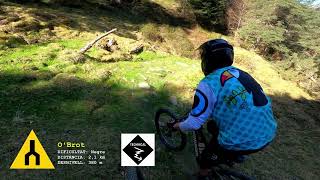
Cette piste très roulante sur sa partie supérieur, devient technique à
mesure que vous descendez pour finir par des sections engagées au
milieu de blocs. Esthétique et ludique si vous avez le niveau
d'engagement adéquat cette ligne comporte de nombreuses surprises
et trajectoires.

English :
This very rolling track on its upper part, becomes technical as you
descend to end up with sections engaged in the middle of blocks.
Aesthetic and playful if you have the right level of commitment this
line has many surprises and trajectories.

Spain :
Esta pista muy rodante en su parte superior se convierte en técnica a
medida que desciendes y terminas con secciones en medio de bloques.
Estético y lúdico si tienes el nivel de compromiso adecuado esta línea
tiene muchas sorpresas y trayectorias.

Access Info

Départ de la télécabine de Vignec saint lary. suivre le balisage FFC monté par la route jusqu'au village d'Ens.
Strat from the Gondola of Vignec/Saint Lary follow the FFC marking uphill by the road to the Ens village

Recent Activity on Trail

Past Week
  • 1 rides
  • 17.5 km average
6 Months
  • 11 rides
  • 23.1 km avg distance
All
  • 54 rides
  • Last: Jun 13, 2026
c1c2c3c4
January
February
March
April
May
June
July
August
September
October
November
December
Status:
on Jun 2, 2026
Dry
Avg: 4.69 (18 votes)
Your vote: 0

view (418)
close
3D
Trail Conditions
  • Unknown
  • Snow Groomed
  • Snow Packed
  • Snow Covered
  • Snow Cover Partial
  • Freeze/thaw Cycle
  • Icy
  • Prevalent Mud
  • Wet
  • Variable
  • Ideal
  • Dry
  • Very Dry
Trail Flow (Ridden Direction)
Trailforks scans users ridelogs to determine the most popular direction each trail is ridden. A good flowing trail network will have most trails flowing in a single direction according to their intension.
The colour categories are based on what percentage of riders are riding a trail in its intended direction.
  • > 96%
  • > 90%
  • > 80%
  • > 70%
  • > 50%
  • < 50%
  • bi-directional trail
  • no data
Trail Last Ridden
Trailforks scans ridelogs to determine the last time a trail was ridden.
  • < 2 days
  • < 1 week
  • < 2 weeks
  • < 1 month
  • < 6 months
  • > 6 months
Trail Ridden Direction
The intended direction a trail should be ridden.
  • Downhill Only
  • Downhill Primary
  • Both Directions
  • Uphill Primary
  • Uphill Only
  • One Direction
Contribute Details
Colors indicate trail is missing specified detail.
  • Description
  • Photos
  • Description & Photos
  • Videos
Trail Popularity ?
Trailforks scans ridelogs to determine which trails are ridden the most in the last 9 months. Trails are compared with nearby trails in the same city region with a possible 25 colour shades. Think of this as a heatmap, more rides = more kinetic energy = warmer colors.
  • most popular
  • popular
  • less popular
  • not popular
ATV/ORV/OHV Filter
Max Vehicle Width
inches
US Cell Coverage
Legend
cell carrier legend

Radar Time
Activity Recordings
Trailforks uses anonymized public activity data. ?
Activity Recordings
Trailforks uses anonymized public activity data. ?
Personal Heatmap
Activity Types
all / none
Options
2
Date range month
Winter Trails
Warning A routing network for winter maps does not exist. Selecting trails using the winter trails layer has been disabled.
Missing Trails
Most Popular
Least Popular
Trails are colored based on popularity. The more popular a trail is, the more red. Less popular trails trend towards green.
Jump Magnitude Heatmap
Heatmap of where riders jump on trails. Zoom in to see individual jumps, click circles to view jump details.
BC Backroad Status

Service Road Atlas is a free to use, community-driven service for viewing and creating reports on the numerous back-country service roads around B.C. and Alberta.

map legend
Slope Aspect
Direction the slope faces
Flat N NE E SE S SW W NW
Trails Deemphasized
Trails are shown in grey.
disable
Only show trails with no bike usage.
Enable
Suggested Layers
Based on selected activity type

    Save the current map location and zoom level as your default home location whenever this page is loaded.

    Save
        Directions to o-brot trailhead (42.801940, 0.323020)

        Photos

        2 more »
        109 |
        Jul 24, 2022 @ 9:01am
        Jul 24, 2022
        139 |
        Jul 24, 2022 @ 9:01am
        Jul 24, 2022

        Videos

        4 more »
        youtuber O'Brot psicòtic amb flow
        6:55 | 44 | Apr 17, 2026 , Saint Lary Soulan
        Emtb/Bajadotes en Ens , O Brot TOP. #ebike...
        16:15 | 60 | Apr 17, 2026 , Saint Lary Soulan
        VTT enduro piste noire 'O Brot' à Ens...
        7:52 | 718 | Aug 14, 2022 , Saint Lary Soulan
        louis diomede trankilmont sur...
        2:31 | 492 | Oct 5, 2020 , Saint Lary Soulan

        9 Reviews & Comments


        We hope you've been enjoying Trailforks!

        Create a FREE account to view trail comments and much more.

        • By MountainlinesTF Pro & contributors
        • #313447 - 1,910 views

        Frequently Asked Questions About O Brot

        Where is O Brot located?
        O Brot is located in Saint-Lary Enduro, Saint Lary Soulan, France. It is part of the Saint-Lary Enduro trail network. The trailhead is located at coordinates 42.80194, 0.32302.
        How hard is O Brot?
        O Brot is rated as Black difficulty. The physical rating is Hard. The average grade is 22.1%. The climb difficulty is rated Black Diamond.
        What is the elevation gain for O Brot?
        O Brot has 1 m of elevation gain. The trail has 371 m of elevation descent. The elevation ranges from 993 m to 1,362 m.
        How long is O Brot?
        O Brot is 1.7 km long. The trail type is singletrack.

        Hit the Trail

        Open in App

        Get this trail on your phone instantly.
        open trail in app

        Download Trail

        Save to wishlist, Garmin & download.
        save the trail

        Find Related Routes

        Find routes and users activities that include this trail.
        find routes for this trail

        You must enter a description before submitting.