more stats
5.2 miles
Distance
1,406 ft
Climb
-103 ft
Descent
00:52:55
Avg time
1,303 ft
Altitude change
50 ft
Altitude min
1,353 ft
Altitude max
51 ft
Altitude start
1,355 ft
Altitude end
4.7%
Grade
-11.7%
Grade max
50.2%
Grade min
4 miles
Distance climb
2,956 ft
Distance down
3,806 ft
Distance flat
00:52:55
Avg time

Oats Peak Details

  • Activities
    • Mountain Bike
    • E-Bike
    • Horse
    • Hike
    • Trail Running
  • Riding Area
    Montana de Oro State Park
    Los Osos, California
  • Difficulty Rating
  • Voted Difficulty
    Green (3 votes)
  • Local Popularity
    85 in Mountain Biking [+]
    • 60 in E-Biking
    • 65 in Trail Running
    • 85 in Hiking
    • 5 in Horseback
  • Global Ranking
    #34837 in Mountain Biking [+]
    • #43831 in E-Biking
    • #53267 in Trail Running
    • #2341 in Hiking
    • #905 in Horseback
  • Trail Type
    Singletrack
  • Direction
    Both Directions
  • Climb Difficulty
    Blue
  • Physical Rating
    Moderate
  • Trail Visibility
    Always easy to follow
  • Season
    Year Round
  • eBike Allowed
    Yes up to Class 1
  • Ride in Rain
    Yes
  • Land Owner

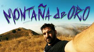
Newest trail opened to MTB in the Montana de Oro. One of four trails south of Islay Creek open to biking.(Others include Beebee trail, Reservoir Flats trail and the Bluff trail) Approx 11 miles round trip, be prepared for some pedaling and a fun descent. Last .5 mile at the summit is steep and rocky, beginners be warned. Otherwise a fun trail for almost all riders. Great views. Be mindful of poison oak in sections.

Access Info

Trailhead is located just passed Spooners Cove. Park in the general area of the white ranch house, and pedal back passed the bath rooms toward the campground. Trailhead is on your right.

Trail Supporters
  • CCCMB
    Maintainer
Local Trail Association
Traditionally Indigenous Territory

Recent Activity on Trail

Past Week
  • 3 rides
  • 12 miles average
6 Months
  • 108 rides
  • 13 miles avg distance
All
  • 407 rides
  • Last: Jun 18, 2026
c1c2c3c4
January
February
March
April
May
June
July
August
September
October
November
December
update trails status or condition

Oats Peak Trail Reports

statusdatedescription
Nov 28, 2025 @ 10:51am (America/Los_Angeles)
Nov 28, 2025
Jun 19, 2025 @ 12:06am
Jun 19, 2025
Ridden on 06/18/25 trail is running beautifully. No issues except really really dusty conditions. Brakes didn’t like it!
May 16, 2025 @ 10:03am
May 16, 2025
Some poison oak encroaching into trail. Watch the knuckles.
May 4, 2025 @ 2:48pm
May 4, 2025
some poison oak hanging over in the trail at upper Oats. I've been breaking it off but there's more ready to take its place. needs a good haircut.
Apr 26, 2025 @ 6:45pm
Apr 26, 2025
Too section after the, upper BeeBee connector, is a bit overgrown with lots of poison oak in sections. Hard to avoid on the DH
more »
Status:
on Nov 28, 2025
Ideal
Avg: 4.22 (28 votes)
Your vote: 0

view (1,926)
close
3D
Trail Conditions
  • Unknown
  • Snow Groomed
  • Snow Packed
  • Snow Covered
  • Snow Cover Partial
  • Freeze/thaw Cycle
  • Icy
  • Prevalent Mud
  • Wet
  • Variable
  • Ideal
  • Dry
  • Very Dry
Trail Flow (Ridden Direction)
Trailforks scans users ridelogs to determine the most popular direction each trail is ridden. A good flowing trail network will have most trails flowing in a single direction according to their intension.
The colour categories are based on what percentage of riders are riding a trail in its intended direction.
  • > 96%
  • > 90%
  • > 80%
  • > 70%
  • > 50%
  • < 50%
  • bi-directional trail
  • no data
Trail Last Ridden
Trailforks scans ridelogs to determine the last time a trail was ridden.
  • < 2 days
  • < 1 week
  • < 2 weeks
  • < 1 month
  • < 6 months
  • > 6 months
Trail Ridden Direction
The intended direction a trail should be ridden.
  • Downhill Only
  • Downhill Primary
  • Both Directions
  • Uphill Primary
  • Uphill Only
  • One Direction
Contribute Details
Colors indicate trail is missing specified detail.
  • Description
  • Photos
  • Description & Photos
  • Videos
Trail Popularity ?
Trailforks scans ridelogs to determine which trails are ridden the most in the last 9 months. Trails are compared with nearby trails in the same city region with a possible 25 colour shades. Think of this as a heatmap, more rides = more kinetic energy = warmer colors.
  • most popular
  • popular
  • less popular
  • not popular
ATV/ORV/OHV Filter
Max Vehicle Width
inches
US Cell Coverage
Legend
cell carrier legend

Radar Time
Activity Recordings
Trailforks uses anonymized public activity data. ?
Activity Recordings
Trailforks uses anonymized public activity data. ?
Personal Heatmap
Activity Types
all / none
Options
2
Date range month
Winter Trails
Warning A routing network for winter maps does not exist. Selecting trails using the winter trails layer has been disabled.
Missing Trails
Most Popular
Least Popular
Trails are colored based on popularity. The more popular a trail is, the more red. Less popular trails trend towards green.
Jump Magnitude Heatmap
Heatmap of where riders jump on trails. Zoom in to see individual jumps, click circles to view jump details.
BC Backroad Status

Service Road Atlas is a free to use, community-driven service for viewing and creating reports on the numerous back-country service roads around B.C. and Alberta.

map legend
Slope Aspect
Direction the slope faces
Flat N NE E SE S SW W NW
Trails Deemphasized
Trails are shown in grey.
disable
Only show trails with no bike usage.
Enable
Suggested Layers
Based on selected activity type

    Save the current map location and zoom level as your default home location whenever this page is loaded.

    Save
        Directions to oats-peak trailhead (35.274090, -120.885900)

        Photos

        110 more »
        65 |
        Nov 2, 2024 @ 1:38pm
        Nov 2, 2024
        56 |
        Oct 1, 2022 @ 3:50pm
        Oct 1, 2022
        49 |
        Oct 1, 2022 @ 3:50pm
        Oct 1, 2022
        54 |
        Oct 1, 2022 @ 3:50pm
        Oct 1, 2022

        Videos

        17 more »
        youtuber 6 Mile DH With the Ocean On Your Back: Oats Peak
        17:08 | 309 | Nov 13, 2023 , Los Osos
        youtuber Oats Peak - Los Osos\San Luis Obispo, CA
        21:41 | 325 | May 24, 2020 , Los Osos
        youtuber Oats Peak Trail - Los Oso \ San Luis Obispo, CA
        22:34 | 820 | Jun 16, 2019 , Los Osos
        Scenic Mountain Biking at Montaña de Oro
        11:41 | 79 | Jul 27, 2024 , Los Osos

        Routes with this trail

        5.0 6 miles 734 ft 9 Loop
        quick loop with some great views
        28 miles 4,199 ft 66 Loop
        Fairly Large All Mountain ride at MDO, great for visitors as you get to see all parts of the park and most...
        10 miles 1,178 ft 12
        Bday ride uphill and downhill.

        Links

        8 Reviews & Comments


        We hope you've been enjoying Trailforks!

        Create a FREE account to view trail comments and much more.

        • By krisraynerTF Pro & contributors
        • #21064 - 11,294 views

        Frequently Asked Questions About Oats Peak

        Where is Oats Peak located?
        Oats Peak is located in Montana de Oro State Park, Los Osos, California, United States. It is part of the Montana de Oro State Park trail network. The trailhead is located at coordinates 35.27409, -120.8859.
        How hard is Oats Peak?
        Oats Peak is rated as Blue difficulty. The physical rating is Moderate. The average grade is 4.7%. The climb difficulty is rated Blue.
        What is the elevation gain for Oats Peak?
        Oats Peak has 1,406 ft of elevation gain. The trail has 103 ft of elevation descent. The elevation ranges from 50 ft to 1,353 ft.
        Is Oats Peak a point to point trail?
        Oats Peak is not a point to point trail. The direction is Both Directions. The trail type is singletrack.

        Hit the Trail

        Open in App

        Get this trail on your phone instantly.
        open trail in app

        Download Trail

        Save to wishlist, Garmin & download.
        save the trail

        Find Related Routes

        Find routes and users activities that include this trail.
        find routes for this trail

        You must enter a description before submitting.