more stats
1.7 miles
Distance
18 ft
Climb
-1,102 ft
Descent
00:20:00
Avg time
-1,086 ft
Altitude change
2,399 ft
Altitude min
3,485 ft
Altitude max
3,484 ft
Altitude start
2,398 ft
Altitude end
-12.3%
Grade
-56.7%
Grade max
8.7%
Grade min
367 ft
Distance climb
1 mile
Distance down
659 ft
Distance flat
00:20:00
Avg time

Oblivion Details

  • Activities
    • Mountain Bike
    • E-Bike
  • Riding Area
    Kelowna
    , British Columbia
  • Difficulty Rating
  • Voted Difficulty
    Black Diamond (3 votes)
  • Local Popularity
    55 in Mountain Biking [+]
    • 75 in E-Biking
  • Global Ranking
    #96380 in Mountain Biking [+]
    • #50985 in E-Biking
  • Trail Type
    Singletrack
  • Bike Type
    AM
  • Physical Rating
    Hard
  • Dogs Allowed
    Yes
  • eBike Allowed
    Yes up to Class 1
  • TTFs on Trail
    Rock Face, Rock Garden

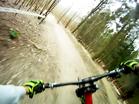
Oblivion is flowy AM descent with plenty of natural rock features, technical sections, and breathtaking views of Okanagan Lake. At times the trail can be difficult to identify especially after the last steep shoot by the gas line. Be sure to have your Trailforks app handy. You can shuttle Oblivion using Chute Lake Rd if you have a capable 4x4 vehicle. Pedaling up Chute Lake Rd takes about 1 hour from Kettle Valley subdivision. Its grueling and relentless. Oblivion ends at Cedar Mountain Regional Park where you can continue on a park trail along Lebanon Creek. Mid way down take the Pinot Dirt trail. That route will take you to Kettle Valley subdivision or continue down to Okanagan Lake. Enjoy

Local Trail Association
Traditionally Indigenous Territory

Recent Activity on Trail

Past Week
  • 0 rides
  •  
6 Months
  • 5 rides
  • 10 miles avg distance
All
  • 46 rides
  • Last: Jun 7, 2026
c1c2c3c4
January
February
March
April
May
June
July
August
September
October
November
December
update trails status or condition

Oblivion Trail Reports

statusdatedescription
Mar 28, 2026 @ 7:27pm (America/Vancouver)
Mar 28, 2026
reporter So mint. Doesn't get any better than right now.
Feb 14, 2026 @ 1:42pm (America/Vancouver)
Feb 14, 2026
February 14, 2026 and running great. No issues.
Sep 14, 2025 @ 8:49am (America/Vancouver)
Sep 14, 2025
Jul 5, 2025 @ 12:19pm
Jul 5, 2025
Apr 18, 2025 @ 3:05pm
Apr 18, 2025
reporter Mint!
more »
Status:
on Mar 28, 2026
Ideal
Avg: 4.23 (11 votes)
Your vote: 0

view (377)
close
3D
Trail Conditions
  • Unknown
  • Snow Groomed
  • Snow Packed
  • Snow Covered
  • Snow Cover Partial
  • Freeze/thaw Cycle
  • Icy
  • Prevalent Mud
  • Wet
  • Variable
  • Ideal
  • Dry
  • Very Dry
Trail Flow (Ridden Direction)
Trailforks scans users ridelogs to determine the most popular direction each trail is ridden. A good flowing trail network will have most trails flowing in a single direction according to their intension.
The colour categories are based on what percentage of riders are riding a trail in its intended direction.
  • > 96%
  • > 90%
  • > 80%
  • > 70%
  • > 50%
  • < 50%
  • bi-directional trail
  • no data
Trail Last Ridden
Trailforks scans ridelogs to determine the last time a trail was ridden.
  • < 2 days
  • < 1 week
  • < 2 weeks
  • < 1 month
  • < 6 months
  • > 6 months
Trail Ridden Direction
The intended direction a trail should be ridden.
  • Downhill Only
  • Downhill Primary
  • Both Directions
  • Uphill Primary
  • Uphill Only
  • One Direction
Contribute Details
Colors indicate trail is missing specified detail.
  • Description
  • Photos
  • Description & Photos
  • Videos
Trail Popularity ?
Trailforks scans ridelogs to determine which trails are ridden the most in the last 9 months. Trails are compared with nearby trails in the same city region with a possible 25 colour shades. Think of this as a heatmap, more rides = more kinetic energy = warmer colors.
  • most popular
  • popular
  • less popular
  • not popular
ATV/ORV/OHV Filter
Max Vehicle Width
inches
US Cell Coverage
Legend
cell carrier legend

Radar Time
Activity Recordings
Trailforks uses anonymized public activity data. ?
Activity Recordings
Trailforks uses anonymized public activity data. ?
Personal Heatmap
Activity Types
all / none
Options
2
Date range month
Winter Trails
Warning A routing network for winter maps does not exist. Selecting trails using the winter trails layer has been disabled.
Missing Trails
Most Popular
Least Popular
Trails are colored based on popularity. The more popular a trail is, the more red. Less popular trails trend towards green.
Jump Magnitude Heatmap
Heatmap of where riders jump on trails. Zoom in to see individual jumps, click circles to view jump details.
BC Backroad Status

Service Road Atlas is a free to use, community-driven service for viewing and creating reports on the numerous back-country service roads around B.C. and Alberta.

map legend
Slope Aspect
Direction the slope faces
Flat N NE E SE S SW W NW
Trails Deemphasized
Trails are shown in grey.
disable
Only show trails with no bike usage.
Enable
Suggested Layers
Based on selected activity type

    Save the current map location and zoom level as your default home location whenever this page is loaded.

    Save
        Directions to oblivion trailhead (49.758310, -119.508650)

        Photos

        40 more »
        211 |
        Nov 12, 2023 @ 12:59pm
        Nov 12, 2023
        98 |
        Jun 8, 2023 @ 5:24pm
        Jun 8, 2023
        140 |
        Jun 8, 2023 @ 5:24pm
        Jun 8, 2023
        127 |
        Jun 23, 2022 @ 3:52pm
        Jun 23, 2022

        Videos

        1 more »
        Chesty oblivion
        0:37 | 881 | Mar 22, 2016 , Kelowna

        4 Reviews & Comments


        We hope you've been enjoying Trailforks!

        Create a FREE account to view trail comments and much more.

        Nearby Trails

        • By k-towntrailryder & contributors
        • #33744 - 7,377 views

        Frequently Asked Questions About Oblivion

        Where is Oblivion located?
        Oblivion is located in Kelowna, British Columbia, Canada. It is part of the Kelowna trail network. The trailhead is located at coordinates 49.75831, -119.50865.
        How hard is Oblivion?
        Oblivion is rated as Black Diamond difficulty. The physical rating is Hard. The average grade is 12.3%.
        What is the elevation gain for Oblivion?
        Oblivion has 18 ft of elevation gain. The trail has 1,102 ft of elevation descent. The elevation ranges from 2,399 ft to 3,485 ft.
        How long is Oblivion?
        Oblivion is 1.7 miles long. The trail type is singletrack.

        Hit the Trail

        Open in App

        Get this trail on your phone instantly.
        open trail in app

        Download Trail

        Save to wishlist, Garmin & download.
        save the trail

        Find Related Routes

        Find routes and users activities that include this trail.
        find routes for this trail

        You must enter a description before submitting.