more stats
305 ft
Distance
8 ft
Climb
-32 ft
Descent
345 ft
High Point
-24 ft
Altitude change
320 ft
Altitude min
344 ft
Altitude start
320 ft
Altitude end
-7.787%
Grade
-25.248%
Grade max
2.743%
Grade min
89 ft
Distance climb
194 ft
Distance down
22 ft
Distance flat

Off camber Details

  • Activities
    • Mountain Bike
  • Riding Area
    Malvina Wood
    Nivelles
  • Difficulty Rating
  • Local Popularity
    10 in Mountain Biking
  • Global Ranking
    #153208 in Mountain Biking
  • Trail Type
    Singletrack
  • Bike Type
    DH, AM, DJ
  • Direction
    Downhill Only
  • Physical Rating
    Moderate
  • Season
    Sandy soil
  • Dogs Allowed
    Yes
  • TTFs on Trail
    Berm, Drop, Jump, Pump Track, Rock Face, Wallride
  • Ride in Rain
    Yes
  • Year Opened
    2016

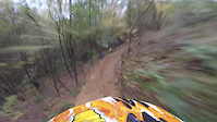
The off camber line construction began in April 2016 so it's the newest line in the wood. It's fast, sandy, off camber and technical. Jumps and rollins on the track, and a super sketchy 180 turn to join the Sand track at the end. Mega FUN

I dedicate this track to Stevie Smith who just passed, way too young. Ride in Peace Stevie #longlivechainsaw #irideforstevie

La Off camber est est la ligne la plus récente du spot, avec la création en mai 2016. C'est une ligne technique, rapide et avec du dévers, elle contient de l'aerien, et un 180 tres technique à la fin avant de rejoindre la Sand track. Mega FUN !

Je dédie cette piste à Steve Smith, qui nous a quitté beaucoup trop tôt. Ride in Peace Stevie ! #longlivechainsaw #irideforstevie

Trail Supporters

Recent Activity on Trail

Past Week
  • 0 rides
  •  
6 Months
  • 0 rides
  •  
All
  • 1 rides
  • Last: Feb 3, 2026
update trails status or condition

Off camber Trail Reports

no reports have been added for Off camber yet, add a trail report.
Trail reports are used to indicate a trails current condition and inform builders and other riders about any issues on a trail.
Status:
Avg: 4.13 (1 votes)
Your vote: 0

view (11)
close
3D
Trail Conditions
  • Unknown
  • Snow Groomed
  • Snow Packed
  • Snow Covered
  • Snow Cover Partial
  • Freeze/thaw Cycle
  • Icy
  • Prevalent Mud
  • Wet
  • Variable
  • Ideal
  • Dry
  • Very Dry
Trail Flow (Ridden Direction)
Trailforks scans users ridelogs to determine the most popular direction each trail is ridden. A good flowing trail network will have most trails flowing in a single direction according to their intension.
The colour categories are based on what percentage of riders are riding a trail in its intended direction.
  • > 96%
  • > 90%
  • > 80%
  • > 70%
  • > 50%
  • < 50%
  • bi-directional trail
  • no data
Trail Last Ridden
Trailforks scans ridelogs to determine the last time a trail was ridden.
  • < 2 days
  • < 1 week
  • < 2 weeks
  • < 1 month
  • < 6 months
  • > 6 months
Trail Ridden Direction
The intended direction a trail should be ridden.
  • Downhill Only
  • Downhill Primary
  • Both Directions
  • Uphill Primary
  • Uphill Only
  • One Direction
Contribute Details
Colors indicate trail is missing specified detail.
  • Description
  • Photos
  • Description & Photos
  • Videos
Trail Popularity ?
Trailforks scans ridelogs to determine which trails are ridden the most in the last 9 months. Trails are compared with nearby trails in the same city region with a possible 25 colour shades. Think of this as a heatmap, more rides = more kinetic energy = warmer colors.
  • most popular
  • popular
  • less popular
  • not popular
ATV/ORV/OHV Filter
Max Vehicle Width
inches
US Cell Coverage
Legend
cell carrier legend

Radar Time
Activity Recordings
Trailforks uses anonymized public activity data. ?
Activity Recordings
Trailforks uses anonymized public activity data. ?
Personal Heatmap
Activity Types
all / none
Options
2
Date range month
Winter Trails
Warning A routing network for winter maps does not exist. Selecting trails using the winter trails layer has been disabled.
Missing Trails
Most Popular
Least Popular
Trails are colored based on popularity. The more popular a trail is, the more red. Less popular trails trend towards green.
Jump Magnitude Heatmap
Heatmap of where riders jump on trails. Zoom in to see individual jumps, click circles to view jump details.
BC Backroad Status

Service Road Atlas is a free to use, community-driven service for viewing and creating reports on the numerous back-country service roads around B.C. and Alberta.

map legend
Slope Aspect
Direction the slope faces
Flat N NE E SE S SW W NW
Trails Deemphasized
Trails are shown in grey.
disable
Only show trails with no bike usage.
Enable
Suggested Layers
Based on selected activity type

    Save the current map location and zoom level as your default home location whenever this page is loaded.

    Save
        Directions to off-camber-55815 trailhead (50.675640, 4.554160)

        Photos

        1 more »
        384 |
        Jan 26, 2018 @ 1:46pm
        Jan 26, 2018

        Videos

        2 more »
        The Off Camber
        0:39 | 215 | Oct 31, 2017 , Nivelles
        Citadelle DH
        0:07 | 112 | Oct 4, 2009 , Nivelles

        Reviews / Comments

        No reviews yet, be the first to write a review or ask a question.
        Use trail reports to comment on trail conditions.


        We hope you've been enjoying Trailforks!

        Create a FREE account to view trail comments and much more.

        • By RedBurn & contributors
        • #55815 - 1,413 views

        Frequently Asked Questions About Off camber

        Where is Off camber located?
        Off camber is located in Malvina Wood, Nivelles, Belgium. It is part of the Malvina Wood trail network. The trailhead is located at coordinates 50.67564, 4.55416.
        How hard is Off camber?
        Off camber is rated as Red difficulty. The physical rating is Moderate. The average grade is 7.787%.
        What is the elevation gain for Off camber?
        Off camber has 8 ft of elevation gain. The trail has 32 ft of elevation descent. The elevation ranges from 320 ft to 345 ft.
        Is Off camber a point to point trail?
        Yes, Off camber is a point to point trail. The direction is Downhill Only. The trail type is singletrack.

        Hit the Trail

        Open in App

        Get this trail on your phone instantly.
        open trail in app

        Download Trail

        Save to wishlist, Garmin & download.
        save the trail

        Find Related Routes

        Find routes and users activities that include this trail.
        find routes for this trail

        You must enter a description before submitting.