more stats
2.0 miles
Distance
41 ft
Climb
-878 ft
Descent
00:16:45
Avg time
-839 ft
Altitude change
1,981 ft
Altitude min
2,820 ft
Altitude max
2,820 ft
Altitude start
1,982 ft
Altitude end
-7.8%
Grade
-30.9%
Grade max
18.9%
Grade min
925 ft
Distance climb
2 miles
Distance down
476 ft
Distance flat
00:16:45
Avg time

Off The Grid (OTG) Details

  • Activities
    • Mountain Bike
    • Winter Fat Bike
  • Riding Area
    Tiger Mountain State Forest
    Issaquah, Washington
  • AKA
    OTG
  • Difficulty Rating
  • Voted Difficulty
    Blue (29 votes)
  • Local Popularity
    80 in Mountain Biking
  • Global Ranking
    #180 in Mountain Biking
  • Trail Exposure
    High Risk
  • Trail Type
    Singletrack
  • Bike Type
    DH, AM
  • Climb Difficulty
    Blue
  • Physical Rating
    Hard
  • Trail Visibility
    Always easy to follow
  • Season
    3
  • Dogs Allowed
    Yes
  • eBike Allowed
  • TTFs on Trail
    Berm, Drop, Jump
  • Ride in Rain
    Yes
  • Land Owner
    Washington State DNR

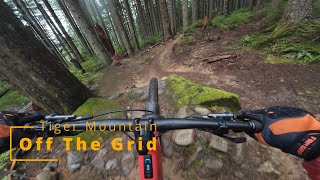
A truly great trail. Catch the start by taking a right at the trail junction off the East Tiger Summit trail after it crosses the summit road. Like the other new trails on Tiger, OTG has a bit of everything. It's mostly flowy, but also has its share of tech and gnar (roots and some short rocks gardens). This is a long descent, broken up by a punchy uphill section about a 3rd of the way down. For a descent, it's pretty aerobic. The rock gardens can be very greasy when wet, and thus can be difficult to ride cleanly then - especially the off-camber one. OTG exits right at the top of Fully Rigid.

Local Trail Association
Traditionally Indigenous Territory

Recent Activity on Trail

Past Week
  • 21 rides
  • 13 miles average
6 Months
  • 233 rides
  • 12 miles avg distance
All
  • 2,652 rides
  • Last: Jun 16, 2026
c1c2c3c4
January
February
March
April
May
June
July
August
September
October
November
December
Status:
on Jun 11, 2026
Ideal
Avg: 4.43 (122 votes)
Your vote: 0

view (15,050)
close
3D
Trail Conditions
  • Unknown
  • Snow Groomed
  • Snow Packed
  • Snow Covered
  • Snow Cover Partial
  • Freeze/thaw Cycle
  • Icy
  • Prevalent Mud
  • Wet
  • Variable
  • Ideal
  • Dry
  • Very Dry
Trail Flow (Ridden Direction)
Trailforks scans users ridelogs to determine the most popular direction each trail is ridden. A good flowing trail network will have most trails flowing in a single direction according to their intension.
The colour categories are based on what percentage of riders are riding a trail in its intended direction.
  • > 96%
  • > 90%
  • > 80%
  • > 70%
  • > 50%
  • < 50%
  • bi-directional trail
  • no data
Trail Last Ridden
Trailforks scans ridelogs to determine the last time a trail was ridden.
  • < 2 days
  • < 1 week
  • < 2 weeks
  • < 1 month
  • < 6 months
  • > 6 months
Trail Ridden Direction
The intended direction a trail should be ridden.
  • Downhill Only
  • Downhill Primary
  • Both Directions
  • Uphill Primary
  • Uphill Only
  • One Direction
Contribute Details
Colors indicate trail is missing specified detail.
  • Description
  • Photos
  • Description & Photos
  • Videos
Trail Popularity ?
Trailforks scans ridelogs to determine which trails are ridden the most in the last 9 months. Trails are compared with nearby trails in the same city region with a possible 25 colour shades. Think of this as a heatmap, more rides = more kinetic energy = warmer colors.
  • most popular
  • popular
  • less popular
  • not popular
ATV/ORV/OHV Filter
Max Vehicle Width
inches
US Cell Coverage
Legend
cell carrier legend

Radar Time
Activity Recordings
Trailforks uses anonymized public activity data. ?
Activity Recordings
Trailforks uses anonymized public activity data. ?
Personal Heatmap
Activity Types
all / none
Options
2
Date range month
Winter Trails
Warning A routing network for winter maps does not exist. Selecting trails using the winter trails layer has been disabled.
Missing Trails
Most Popular
Least Popular
Trails are colored based on popularity. The more popular a trail is, the more red. Less popular trails trend towards green.
Jump Magnitude Heatmap
Heatmap of where riders jump on trails. Zoom in to see individual jumps, click circles to view jump details.
BC Backroad Status

Service Road Atlas is a free to use, community-driven service for viewing and creating reports on the numerous back-country service roads around B.C. and Alberta.

map legend
Slope Aspect
Direction the slope faces
Flat N NE E SE S SW W NW
Trails Deemphasized
Trails are shown in grey.
disable
Only show trails with no bike usage.
Enable
Suggested Layers
Based on selected activity type

    Save the current map location and zoom level as your default home location whenever this page is loaded.

    Save
        Directions to off-the-grid-otg trailhead (47.491250, -121.944100)

        Photos

        79 more »
        1,765 |
        Sep 22, 2015 @ 10:14am
        Sep 22, 2015
        1,447 |
        Sep 22, 2015 @ 10:14am
        Sep 22, 2015
        1,154 |
        Sep 22, 2015 @ 10:14am
        Sep 22, 2015
        1,682 |
        Sep 22, 2015 @ 10:17am
        Sep 22, 2015

        Videos

        23 more »
        youtuber Seattle 2017: Eating #%@ on 'Off the Grid',...
        0:49 | 2142 | Sep 23, 2017 , Issaquah
        youtuber POV: After The Spring Storm Ride of Tiger...
        8:10 | 60 | Mar 30, 2026 , Issaquah
        STAR WARS SPEEDS on TIGER MOUNTAIN, WA -  OTG,...
        22:47 | 210 | Nov 3, 2024 , Issaquah
        Off The Grid It's a ripper of a trail!
        11:50 | 460 | Jul 22, 2024 , Issaquah

        Trail Lists

        Routes with this trail

        10 miles 2,051 ft 8
        Tiger loop up to OTG and then over to EBAD and out
        4.4 10 miles 1,955 ft 6 Loop
        This is the standard Tiger lap from the top. From either parking lot, take the and trails and then the...
        3.7 10 miles 2,367 ft 13 Loop
        Great All Mountain bang-for-the-buck route. Over 3,500 feet vert of climbing, great summit views, followed...

        30 Reviews & Comments


        We hope you've been enjoying Trailforks!

        Create a FREE account to view trail comments and much more.

        • By jebikeTF Pro & contributors
        • #17243 - 32,268 views

        Frequently Asked Questions About Off The Grid (OTG)

        Where is Off The Grid (OTG) located?
        Off The Grid (OTG) is located in Tiger Mountain State Forest, Issaquah, Washington, United States. It is part of the Tiger Mountain State Forest trail network. The trailhead is located at coordinates 47.49125, -121.9441.
        How hard is Off The Grid (OTG)?
        Off The Grid (OTG) is rated as Black Diamond difficulty. The physical rating is Hard. The average grade is 7.8%. The climb difficulty is rated Blue.
        What is the elevation gain for Off The Grid (OTG)?
        Off The Grid (OTG) has 41 ft of elevation gain. The trail has 878 ft of elevation descent. The elevation ranges from 1,981 ft to 2,820 ft.
        How long is Off The Grid (OTG)?
        Off The Grid (OTG) is 2.0 miles long. The trail type is singletrack.

        Hit the Trail

        Open in App

        Get this trail on your phone instantly.
        open trail in app

        Download Trail

        Save to wishlist, Garmin & download.
        save the trail

        Find Related Routes

        Find routes and users activities that include this trail.
        find routes for this trail

        You must enter a description before submitting.