more stats
47.4 miles
Distance
9,359 ft
Climb
-9,632 ft
Descent
15:11:57
Avg time
-273 ft
Altitude change
109 ft
Altitude min
4,417 ft
Altitude max
385 ft
Altitude start
112 ft
Altitude end
-0.1%
Grade
-67.5%
Grade max
90.8%
Grade min
21 miles
Distance climb
23 miles
Distance down
3 miles
Distance flat
15:11:57
Avg time

Old Ghost Road Details

  • Activities
    • Mountain Bike
    • Hike
    • Trail Running
  • Riding Area
  • Difficulty Rating
  • Voted Difficulty
    Black Diamond (1 vote)
  • Local Popularity
    100 in Mountain Biking [+]
    • 100 in Trail Running
    • 5 in Hiking
  • Global Ranking
    #326 in Mountain Biking [+]
    • #34 in Trail Running
    • #2044 in Hiking
  • Hiking SAC Scale
    T3 Demanding Mountain Hiking
  • Trail Type
    Singletrack
  • Bike Type
    AM, XC
  • Direction
    Both Directions
    Popular Direction Shown
  • Climb Difficulty
    Blue
  • Physical Rating
    Moderate
  • Trail Visibility
    Always easy to follow
  • Alpine Trail
    Yes
  • Dogs Allowed
    Yes
  • TTFs on Trail
    Berm, Bridge, Rock Garden, Other
  • Land Owner

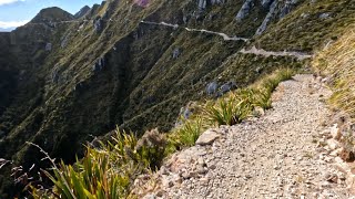
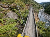
In the North West corner of the South Island of New Zealand a ghost is awakening. A long-forgotten gold miners’ road is being revived as a mountain biking and tramping trail – connecting the old dray road in the Lyell (Upper Buller Gorge) to the mighty Mokihinui River in the north. The 85km-long Old Ghost Road will traverse majestic native forest, open tussock tops, river flats and forgotten valleys.

A proud member of the New Zealand Cycle Trail, the volunteer-driven Mokihinui-Lyell Backcountry Trust is partnering with a range of other entities to make The Old Ghost Road a reality. It’s almost as if the engineers from the 1870’s knew we were coming The spirits of the old miners and track builders are inescapable. No less than five ghost towns populate the route. The Old Ghost Road is quite literally an 85km-long outdoor museum.

The Old Ghost Road is a work in progress and is due for completion in late 2015 (refer to our Trail Status page for updates).
Our volunteers and supporters know that each generation grows up in an increasingly urbanised environment. The connection to the land dims. Here, on The Old Ghost Road, heritage, wilderness, accessibility and storytelling come together in an unforgettable way. We invite you to join the journey……

See http://www.oldghostroad.org.nz/ for updated information on trail status and hut booking.

Access Info

The Old Ghost Road’s trail heads are two hours drive apart – or 4-5 days tramp Various options are available for cyclists and trampers.

Due to The Old Ghost Road’s elevation profile, Lyell is the suggested starting point for through-trampers (and, by late 2015, through-cyclists). 1200m elevation is gained via a steady climb past the Lyell Saddle Hut and up to Ghost Lake, while the descent into Stern Valley and Goat Creek is steeper and more technical. Riders and trampers can enjoy day and overnight trips from this end, which features lush beech forest, historic artifacts, and in the Lyell Saddle to Ghost Lake section, sweeping views.
The Lyell Historic Reserve has ample parking, a Department of Conservation Campground, water and toilet facilities. It is 62km east of Westport, 15km east of Inangahua or 35km south of Murchison on State Highway 6 in the Upper Buller Gorge.
Grid reference: NZTM2000, E1520990-N5372328
Latitude: -41.79697466, Longitude: 172.04899791

Trail Supporters
Local Trail Association

Recent Activity on Trail

Past Week
  • 0 rides
  •  
6 Months
  • 14 rides
  • 65.2 km avg distance
All
  • 65 rides
  • Last: May 14, 2026
c1c2c3c4
January
February
March
April
May
June
July
August
September
October
November
December
update trails status or condition

Old Ghost Road Trail Reports

statusdatedescription
Aug 5, 2025 @ 12:57pm
Aug 5, 2025
Mostly dry, some wet spots between Sedonville and Specimens Point. One tree down on climb up to lyells hut from Lyells car park.
Jun 18, 2025 @ 4:23pm
Jun 18, 2025
Mar 23, 2025 @ 1:59pm
Mar 23, 2025
Mar 23, 2025 @ 1:59pm
Mar 23, 2025
Sep 17, 2024 @ 9:27pm
Sep 17, 2024
Uphill bits to Ghost Lake hut very well manicured. Drop down to Stern Valley less maintained and a better downhill for it. Skyline step bypass...
more »
Status:
on Aug 5, 2025
Ideal
Avg: 4.42 (34 votes)
Your vote: 0

view (467)
close
3D
Trail Conditions
  • Unknown
  • Snow Groomed
  • Snow Packed
  • Snow Covered
  • Snow Cover Partial
  • Freeze/thaw Cycle
  • Icy
  • Prevalent Mud
  • Wet
  • Variable
  • Ideal
  • Dry
  • Very Dry
Trail Flow (Ridden Direction)
Trailforks scans users ridelogs to determine the most popular direction each trail is ridden. A good flowing trail network will have most trails flowing in a single direction according to their intension.
The colour categories are based on what percentage of riders are riding a trail in its intended direction.
  • > 96%
  • > 90%
  • > 80%
  • > 70%
  • > 50%
  • < 50%
  • bi-directional trail
  • no data
Trail Last Ridden
Trailforks scans ridelogs to determine the last time a trail was ridden.
  • < 2 days
  • < 1 week
  • < 2 weeks
  • < 1 month
  • < 6 months
  • > 6 months
Trail Ridden Direction
The intended direction a trail should be ridden.
  • Downhill Only
  • Downhill Primary
  • Both Directions
  • Uphill Primary
  • Uphill Only
  • One Direction
Contribute Details
Colors indicate trail is missing specified detail.
  • Description
  • Photos
  • Description & Photos
  • Videos
Trail Popularity ?
Trailforks scans ridelogs to determine which trails are ridden the most in the last 9 months. Trails are compared with nearby trails in the same city region with a possible 25 colour shades. Think of this as a heatmap, more rides = more kinetic energy = warmer colors.
  • most popular
  • popular
  • less popular
  • not popular
ATV/ORV/OHV Filter
Max Vehicle Width
inches
US Cell Coverage
Legend
cell carrier legend

Radar Time
Activity Recordings
Trailforks uses anonymized public activity data. ?
Activity Recordings
Trailforks uses anonymized public activity data. ?
Personal Heatmap
Activity Types
all / none
Options
2
Date range month
Winter Trails
Warning A routing network for winter maps does not exist. Selecting trails using the winter trails layer has been disabled.
Missing Trails
Most Popular
Least Popular
Trails are colored based on popularity. The more popular a trail is, the more red. Less popular trails trend towards green.
Jump Magnitude Heatmap
Heatmap of where riders jump on trails. Zoom in to see individual jumps, click circles to view jump details.
BC Backroad Status

Service Road Atlas is a free to use, community-driven service for viewing and creating reports on the numerous back-country service roads around B.C. and Alberta.

map legend
Slope Aspect
Direction the slope faces
Flat N NE E SE S SW W NW
Trails Deemphasized
Trails are shown in grey.
disable
Only show trails with no bike usage.
Enable
Suggested Layers
Based on selected activity type

    Save the current map location and zoom level as your default home location whenever this page is loaded.

    Save
        Directions to old-ghost-road trailhead (-41.796130, 172.049620)

        Photos

        304 more »
        27 |
        Mar 13, 2026 @ 1:48pm
        Mar 13, 2026
        83 |
        Sep 18, 2024 @ 1:17am
        Sep 18, 2024
        85 |
        Sep 18, 2024 @ 1:17am
        Sep 18, 2024
        144 |
        May 25, 2023 @ 4:22pm
        May 25, 2023

        Videos

        18 more »
        youtuber Old Ghost Road, Day 2
        37:10 | 152 | Jun 30, 2025 , Westport
        youtuber Old Ghost Road. Day 3.
        35:29 | 72 | Jul 3, 2025 , Westport
        youtuber Old Ghost Road, Day 1
        9:14 | 135 | Jun 23, 2025 , Westport
        Part 2 Frothing cream on the Old Ghost Road -...
        9:07 | 1 | Jun 14, 2026 , Westport

        Trail Lists

        Routes with this trail

        423 miles 53,084 ft 5 Loop
        is a multi day advanced bike packing route around This route has been named by as one of the best...

        15 Reviews & Comments


        We hope you've been enjoying Trailforks!

        Create a FREE account to view trail comments and much more.

        • By YogiNZ & contributors
        • #32191 - 39,515 views

        Frequently Asked Questions About Old Ghost Road

        Where is Old Ghost Road located?
        Old Ghost Road is located in Westport, New Zealand. It is part of the Westport trail network. The trailhead is located at coordinates -41.79613, 172.04962.
        How hard is Old Ghost Road?
        Old Ghost Road is rated as Advanced difficulty. The physical rating is Moderate. The average grade is 0.1%. The climb difficulty is rated Blue.
        What is the elevation gain for Old Ghost Road?
        Old Ghost Road has 2,853 m of elevation gain. The trail has 2,936 m of elevation descent. The elevation ranges from 33 m to 1,346 m.
        Is Old Ghost Road a point to point trail?
        Old Ghost Road is not a point to point trail. The direction is Both Directions. The trail type is singletrack.

        Hit the Trail

        Open in App

        Get this trail on your phone instantly.
        open trail in app

        Download Trail

        Save to wishlist, Garmin & download.
        save the trail

        Find Related Routes

        Find routes and users activities that include this trail.
        find routes for this trail

        You must enter a description before submitting.