more stats
3,944 ft
Distance
-363 ft
Descent
00:06:10
Avg time
-362 ft
Altitude change
793 ft
Altitude min
1,158 ft
Altitude max
1,158 ft
Altitude start
797 ft
Altitude end
-9.2%
Grade
-33.9%
Grade max
2.8%
Grade min
75 ft
Distance climb
3,576 ft
Distance down
292 ft
Distance flat
00:06:10
Avg time

Flowtrail Oliver Details

  • Activities
    • Mountain Bike
    • E-Bike
  • Riding Area
    Stará Turá
    Nove Mesto nad Vahom
  • Difficulty Rating
  • Local Popularity
    85 in Mountain Biking [+]
    • 40 in E-Biking
  • Global Ranking
    #29511 in Mountain Biking [+]
    • #68898 in E-Biking
  • Trail Type
    Singletrack
  • Direction
    One Direction
    Popular Direction Shown
  • Physical Rating
    Easy
  • Trail Visibility
    Always easy to follow
  • Family Friendly
    Yes
  • Dogs Allowed
    Yes
  • eBike Allowed
    Yes up to Class 1
  • TTFs on Trail
    Berm, Drop, Rock Face, Rock Garden, Roller Coaster, Skinny

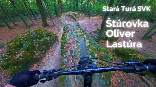
Flowtrail Oliver sa nachádza v rekreačnej oblasti Dubník 1 pri Starej Turej. Ide o hravý a plynulý trail s dĺžkou 1 350 metrov a klesaním približne 110 výškových metrov, ktorý ponúka ideálnu kombináciu zábavy a techniky pre jazdcov všetkých úrovní.

Na trati ťa čaká množstvo zábavných prvkov – klopenky, vlny, lavice, skinny, rockgardeny aj menšie skoky, ktoré si môžeš podľa chuti aj obísť. Trail je vedený v modrej obtiažnosti, takže je vhodný aj pre menej skúsených bikerov, no na viacerých miestach sa nachádzajú alternatívne pasáže s červenou obtiažnosťou, ktoré ponúkajú náročnejšie línie pre pokročilých.

Vďaka svojmu plynulému charakteru a rozmanitosti prvkov je Oliver perfektný trail na zdokonaľovanie techniky, trénovanie flow jazdy a hlavne – na čistú zábavu na dvoch kolesách.


---


Flowtrail Oliver is located in the recreational area Dubník 1 near Stará Turá. It’s a playful and smooth trail, 1,350 meters long with 110 meters of descent, offering a great mix of fun and technical riding for riders of all levels.

Along the trail, you’ll find plenty of exciting features – berms, rollers, tables, skinnies, rock gardens, and smaller jumps that can be rolled or bypassed. The main line follows a blue difficulty, suitable for less experienced riders, while several sections feature optional red lines that challenge advanced riders.

With its smooth flow and variety of features, Oliver is perfect for improving skills, practicing flow riding, and most importantly – having pure fun on two wheels.


-

Recent Activity on Trail

Past Week
  • 0 rides
  •  
6 Months
  • 3 rides
  • 11 miles avg distance
All
  • 29 rides
  • Last: Jun 27, 2026
c1c2c3c4
January
February
March
April
May
June
July
August
September
October
November
December
update trails status or condition

Flowtrail Oliver Trail Reports

statusdatedescription
Apr 30, 2026 @ 2:59pm (Europe/Bratislava)
Apr 30, 2026
Sep 13, 2025 @ 3:12pm (Europe/Bratislava)
Sep 13, 2025
Aug 29, 2025 @ 4:58pm
Aug 29, 2025
May 24, 2025 @ 1:09pm
May 24, 2025
Topka, ako píšu nižšie, treba ísť na Twins
May 23, 2025 @ 9:18am
May 23, 2025
Beautiful flow trail, you should combine it with twins since right now it ends in water
more »
Status:
on Apr 30, 2026
Very Dry
Avg: 4.58 (11 votes)
Your vote: 0

view (351)
close
3D
Trail Conditions
  • Unknown
  • Snow Groomed
  • Snow Packed
  • Snow Covered
  • Snow Cover Partial
  • Freeze/thaw Cycle
  • Icy
  • Prevalent Mud
  • Wet
  • Variable
  • Ideal
  • Dry
  • Very Dry
Trail Flow (Ridden Direction)
Trailforks scans users ridelogs to determine the most popular direction each trail is ridden. A good flowing trail network will have most trails flowing in a single direction according to their intension.
The colour categories are based on what percentage of riders are riding a trail in its intended direction.
  • > 96%
  • > 90%
  • > 80%
  • > 70%
  • > 50%
  • < 50%
  • bi-directional trail
  • no data
Trail Last Ridden
Trailforks scans ridelogs to determine the last time a trail was ridden.
  • < 2 days
  • < 1 week
  • < 2 weeks
  • < 1 month
  • < 6 months
  • > 6 months
Trail Ridden Direction
The intended direction a trail should be ridden.
  • Downhill Only
  • Downhill Primary
  • Both Directions
  • Uphill Primary
  • Uphill Only
  • One Direction
Contribute Details
Colors indicate trail is missing specified detail.
  • Description
  • Photos
  • Description & Photos
  • Videos
Trail Popularity ?
Trailforks scans ridelogs to determine which trails are ridden the most in the last 9 months. Trails are compared with nearby trails in the same city region with a possible 25 colour shades. Think of this as a heatmap, more rides = more kinetic energy = warmer colors.
  • most popular
  • popular
  • less popular
  • not popular
ATV/ORV/OHV Filter
Max Vehicle Width
inches
US Cell Coverage
Legend
cell carrier legend

Radar Time
Activity Recordings
Trailforks uses anonymized public activity data. ?
Activity Recordings
Trailforks uses anonymized public activity data. ?
Personal Heatmap
Activity Types
all / none
Options
2
Date range month
Winter Trails
Warning A routing network for winter maps does not exist. Selecting trails using the winter trails layer has been disabled.
Missing Trails
Most Popular
Least Popular
Trails are colored based on popularity. The more popular a trail is, the more red. Less popular trails trend towards green.
Jump Magnitude Heatmap
Heatmap of where riders jump on trails. Zoom in to see individual jumps, click circles to view jump details.
BC Backroad Status

Service Road Atlas is a free to use, community-driven service for viewing and creating reports on the numerous back-country service roads around B.C. and Alberta.

map legend
Slope Aspect
Direction the slope faces
Flat N NE E SE S SW W NW
Trails Deemphasized
Trails are shown in grey.
disable
Only show trails with no bike usage.
Enable
Suggested Layers
Based on selected activity type

    Save the current map location and zoom level as your default home location whenever this page is loaded.

    Save
        Directions to flowtrail-oliver trailhead (48.756140, 17.692780)

        Photos

        37 more »
        33 |
        Nov 9, 2025 @ 12:06pm
        Nov 9, 2025
        34 |
        Nov 9, 2025 @ 12:06pm
        Nov 9, 2025
        34 |
        Nov 9, 2025 @ 12:06pm
        Nov 9, 2025
        31 |
        Nov 9, 2025 @ 12:06pm
        Nov 9, 2025

        Videos

        2 more »
        Štúrovka Oliver Lastúra  |  Stará Turá
        8:40 | 171 | Dec 14, 2024 , Nove Mesto nad Vahom
        First ride on Oliver Trail
        4:24 | 297 | Sep 13, 2020 , Nove Mesto nad Vahom

        4 Reviews & Comments


        We hope you've been enjoying Trailforks!

        Create a FREE account to view trail comments and much more.

        • By StrenkiTF Pro & contributors
        • #275843 - 4,634 views

        Frequently Asked Questions About Flowtrail Oliver

        Where is Flowtrail Oliver located?
        Flowtrail Oliver is located in Stará Turá, Nove Mesto nad Vahom, Slovakia. It is part of the Stará Turá trail network. The trailhead is located at coordinates 48.75614, 17.69278.
        How hard is Flowtrail Oliver?
        Flowtrail Oliver is rated as Blue difficulty. The physical rating is Easy. The average grade is 9.2%.
        What is the elevation gain for Flowtrail Oliver?
        The trail has 111 m of elevation descent. The elevation ranges from 242 m to 353 m.
        Is Flowtrail Oliver a point to point trail?
        Yes, Flowtrail Oliver is a point to point trail. The direction is One Direction. The trail type is singletrack.

        Hit the Trail

        Open in App

        Get this trail on your phone instantly.
        open trail in app

        Download Trail

        Save to wishlist, Garmin & download.
        save the trail

        Find Related Routes

        Find routes and users activities that include this trail.
        find routes for this trail

        You must enter a description before submitting.