more stats
2,703 ft
Distance
3 ft
Climb
-264 ft
Descent
00:03:18
Avg time
-261 ft
Altitude change
492 ft
Altitude min
754 ft
Altitude max
754 ft
Altitude start
492 ft
Altitude end
-9.7%
Grade
-45.6%
Grade max
33 ft
Distance climb
2,451 ft
Distance down
138 ft
Distance flat
00:03:18
Avg time

Omega Man Details

  • Activities
    • Mountain Bike
    • E-Bike
  • Riding Area
  • AKA
    Shredder Lower
  • Difficulty Rating
  • Local Popularity
    100 in Mountain Biking [+]
    • 100 in E-Biking
  • Global Ranking
    #19676 in Mountain Biking [+]
    • #2599 in E-Biking
  • Trail Type
    Singletrack
  • Bike Type
    DH, AM, XC
  • Direction
    One Direction
  • Physical Rating
    Moderate
  • Dogs Allowed
    Yes
  • eBike Allowed
    Yes up to Class 1
  • TTFs on Trail
    Drop, Jump
  • Ride in Rain
    Yes
  • Land Owner

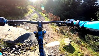
The challenges of this final section demand that you keep your attention focused on the trail ahead as you claw your way around the hillside to gain the jumps and berms leading to the final thrilling decent: a white knuckle ride of step-downs, singles, doubles and tabletops that's as fast (or slow) as you want to make it, with a black-graded option to the left half way down. Either way, you have the choice of the skinny log ride (black grade) or curving but not-too-narrow timber trail (suitable for most riders) that lands you right back at the start.

source: 7stanes - Ae

Recent Activity on Trail

Past Week
  • 1 rides
  • 12 miles average
6 Months
  • 43 rides
  • 12 miles avg distance
All
  • 282 rides
  • Last: Jun 13, 2026
c1c2c3c4
January
February
March
April
May
June
July
August
September
October
November
December
update trails status or condition

Omega Man Trail Reports

statusdatedescription
Apr 6, 2026 @ 8:35pm (Europe/London)
Apr 6, 2026
Running well, minimal breaking bumps
May 26, 2025 @ 12:05pm
May 26, 2025
Mar 10, 2024 @ 3:19pm
Mar 10, 2024
Agreed with previous report it’s not “dangerous” it’s just shite with a couple braking bumps
Oct 25, 2023 @ 12:02pm
Oct 25, 2023
ignore previous reports, trail is ok albeit pretty rubbish
Oct 25, 2023 @ 11:42am
Oct 25, 2023
lots of trail erosion and an already dodgy right/left corner is blown out in the middle making it extra dangerous and sending folk down the...
more »
Status:
on Apr 6, 2026
Ideal
Avg: 3.99 (12 votes)
Your vote: 0

view (5,845)
close
3D
Trail Conditions
  • Unknown
  • Snow Groomed
  • Snow Packed
  • Snow Covered
  • Snow Cover Partial
  • Freeze/thaw Cycle
  • Icy
  • Prevalent Mud
  • Wet
  • Variable
  • Ideal
  • Dry
  • Very Dry
Trail Flow (Ridden Direction)
Trailforks scans users ridelogs to determine the most popular direction each trail is ridden. A good flowing trail network will have most trails flowing in a single direction according to their intension.
The colour categories are based on what percentage of riders are riding a trail in its intended direction.
  • > 96%
  • > 90%
  • > 80%
  • > 70%
  • > 50%
  • < 50%
  • bi-directional trail
  • no data
Trail Last Ridden
Trailforks scans ridelogs to determine the last time a trail was ridden.
  • < 2 days
  • < 1 week
  • < 2 weeks
  • < 1 month
  • < 6 months
  • > 6 months
Trail Ridden Direction
The intended direction a trail should be ridden.
  • Downhill Only
  • Downhill Primary
  • Both Directions
  • Uphill Primary
  • Uphill Only
  • One Direction
Contribute Details
Colors indicate trail is missing specified detail.
  • Description
  • Photos
  • Description & Photos
  • Videos
Trail Popularity ?
Trailforks scans ridelogs to determine which trails are ridden the most in the last 9 months. Trails are compared with nearby trails in the same city region with a possible 25 colour shades. Think of this as a heatmap, more rides = more kinetic energy = warmer colors.
  • most popular
  • popular
  • less popular
  • not popular
ATV/ORV/OHV Filter
Max Vehicle Width
inches
US Cell Coverage
Legend
cell carrier legend

Radar Time
Activity Recordings
Trailforks uses anonymized public activity data. ?
Activity Recordings
Trailforks uses anonymized public activity data. ?
Personal Heatmap
Activity Types
all / none
Options
2
Date range month
Winter Trails
Warning A routing network for winter maps does not exist. Selecting trails using the winter trails layer has been disabled.
Missing Trails
Most Popular
Least Popular
Trails are colored based on popularity. The more popular a trail is, the more red. Less popular trails trend towards green.
Jump Magnitude Heatmap
Heatmap of where riders jump on trails. Zoom in to see individual jumps, click circles to view jump details.
BC Backroad Status

Service Road Atlas is a free to use, community-driven service for viewing and creating reports on the numerous back-country service roads around B.C. and Alberta.

map legend
Slope Aspect
Direction the slope faces
Flat N NE E SE S SW W NW
Trails Deemphasized
Trails are shown in grey.
disable
Only show trails with no bike usage.
Enable
Suggested Layers
Based on selected activity type

    Save the current map location and zoom level as your default home location whenever this page is loaded.

    Save
        Directions to omega-man trailhead (55.202760, -3.595740)

        Photos

        18 more »
        32 |
        Aug 26, 2025 @ 1:32am
        Aug 26, 2025
        187 |
        Apr 2, 2020 @ 2:34pm
        Apr 2, 2020
        242 |
        Feb 12, 2020 @ 11:39am
        Feb 12, 2020
        229 |
        Feb 12, 2020 @ 11:40am
        Feb 12, 2020

        Videos

        7 more »
        Ae for Alpha to Omega.  MTB at Ae Forest,...
        3:09 | 566 | Jul 22, 2020 , Ae
        Forest of Ae | Omega Man (2011)
        0:51 | 288 | Oct 17, 2020 , Ae
        Ae Forest Mountain Biking!
        3:32 | 143 | Jan 17, 2018 , Ae
        New Whip
        2:02 | 96 | Sep 25, 2016 , Ae

        2 Reviews & Comments


        We hope you've been enjoying Trailforks!

        Create a FREE account to view trail comments and much more.

        • By bobochobo & contributors
        • #18444 - 4,294 views

        Frequently Asked Questions About Omega Man

        Where is Omega Man located?
        Omega Man is located in Forest of Ae, Ae, United Kingdom. It is part of the Forest of Ae trail network. The trailhead is located at coordinates 55.20276, -3.59574.
        How hard is Omega Man?
        Omega Man is rated as Red difficulty. The physical rating is Moderate. The average grade is 9.7%.
        What is the elevation gain for Omega Man?
        Omega Man has 1 m of elevation gain. The trail has 81 m of elevation descent. The elevation ranges from 150 m to 230 m.
        Is Omega Man a point to point trail?
        Yes, Omega Man is a point to point trail. The direction is One Direction. The trail type is singletrack.

        Hit the Trail

        Open in App

        Get this trail on your phone instantly.
        open trail in app

        Download Trail

        Save to wishlist, Garmin & download.
        save the trail

        Find Related Routes

        Find routes and users activities that include this trail.
        find routes for this trail

        You must enter a description before submitting.