more stats
7.2 miles
Distance
354 ft
Climb
-354 ft
Descent
00:47:50
Avg time
0 ft
Altitude change
1 ft
Altitude min
44 ft
Altitude max
2 ft
Altitude start
2 ft
Altitude end
0.001%
Grade
-12.049%
Grade max
12.588%
Grade min
3 miles
Distance climb
3 miles
Distance down
2 miles
Distance flat
00:47:50
Avg time

Oostvoorne Details

  • Activities
    • Mountain Bike
  • Riding Area
    Oostvoornse meer
    Oostvoorne
  • AKA
    Oostvoornse meer
  • Difficulty Rating
  • Voted Difficulty
    Blue (2 votes)
  • Local Popularity
    100 in Mountain Biking
  • Global Ranking
    #34540 in Mountain Biking
  • Trail Type
    Singletrack
  • Bike Type
    XC
  • Direction
    One Direction
  • Climb Difficulty
    Green
  • Physical Rating
    Moderate
  • Season
    All season.
  • Dogs Allowed
    Yes
  • TTFs on Trail
    Drop, Jump, Pump Track, Skinny
  • Ride in Rain
    Yes
  • Year Opened
    2009
  • Land Owner

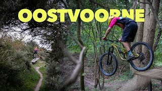
Challenging crosscountry trail. Lots of short ascents and descents. Some intermediate to difficult jumps. Lot's of different terrains; Dirt, sand, clay and even mud. Quite a lot of artificial obstacles as well. Should be ridden counterclockwise so from South eastern corner to north western corner.

Access Info

Can be started from various locations. Location where gps file starts is not recommended since there is no parking space. Easiest place to start would be Hotel van Marion; Zeeweg 60, Oostvoorne.

Local Trail Association

Recent Activity on Trail

Past Week
  • 0 rides
  •  
6 Months
  • 2 rides
  • 12 miles avg distance
All
  • 36 rides
  • Last: Jun 16, 2026
c1c2c3c4
January
February
March
April
May
June
July
August
September
October
November
December
update trails status or condition

Oostvoorne Trail Reports

statusdatedescription
Sep 5, 2025 @ 7:54am
Sep 5, 2025
Just got new jumps and the plants are cut down
Jun 11, 2025 @ 9:29pm
Jun 11, 2025
Some parts a bit overgrown, nice jungle feeling but long sleeve and gloves spare one scratches
May 11, 2025 @ 5:52am
May 11, 2025
Mar 9, 2025 @ 12:57pm
Mar 9, 2025
Nov 10, 2024 @ 2:17pm
Nov 10, 2024
more »
Status:
on Sep 5, 2025
Ideal
Avg: 4.21 (8 votes)
Your vote: 0

view (1,014)
close
3D
Trail Conditions
  • Unknown
  • Snow Groomed
  • Snow Packed
  • Snow Covered
  • Snow Cover Partial
  • Freeze/thaw Cycle
  • Icy
  • Prevalent Mud
  • Wet
  • Variable
  • Ideal
  • Dry
  • Very Dry
Trail Flow (Ridden Direction)
Trailforks scans users ridelogs to determine the most popular direction each trail is ridden. A good flowing trail network will have most trails flowing in a single direction according to their intension.
The colour categories are based on what percentage of riders are riding a trail in its intended direction.
  • > 96%
  • > 90%
  • > 80%
  • > 70%
  • > 50%
  • < 50%
  • bi-directional trail
  • no data
Trail Last Ridden
Trailforks scans ridelogs to determine the last time a trail was ridden.
  • < 2 days
  • < 1 week
  • < 2 weeks
  • < 1 month
  • < 6 months
  • > 6 months
Trail Ridden Direction
The intended direction a trail should be ridden.
  • Downhill Only
  • Downhill Primary
  • Both Directions
  • Uphill Primary
  • Uphill Only
  • One Direction
Contribute Details
Colors indicate trail is missing specified detail.
  • Description
  • Photos
  • Description & Photos
  • Videos
Trail Popularity ?
Trailforks scans ridelogs to determine which trails are ridden the most in the last 9 months. Trails are compared with nearby trails in the same city region with a possible 25 colour shades. Think of this as a heatmap, more rides = more kinetic energy = warmer colors.
  • most popular
  • popular
  • less popular
  • not popular
ATV/ORV/OHV Filter
Max Vehicle Width
inches
US Cell Coverage
Legend
cell carrier legend

Radar Time
Activity Recordings
Trailforks uses anonymized public activity data. ?
Activity Recordings
Trailforks uses anonymized public activity data. ?
Personal Heatmap
Activity Types
all / none
Options
2
Date range month
Winter Trails
Warning A routing network for winter maps does not exist. Selecting trails using the winter trails layer has been disabled.
Missing Trails
Most Popular
Least Popular
Trails are colored based on popularity. The more popular a trail is, the more red. Less popular trails trend towards green.
Jump Magnitude Heatmap
Heatmap of where riders jump on trails. Zoom in to see individual jumps, click circles to view jump details.
BC Backroad Status

Service Road Atlas is a free to use, community-driven service for viewing and creating reports on the numerous back-country service roads around B.C. and Alberta.

map legend
Slope Aspect
Direction the slope faces
Flat N NE E SE S SW W NW
Trails Deemphasized
Trails are shown in grey.
disable
Only show trails with no bike usage.
Enable
Suggested Layers
Based on selected activity type

    Save the current map location and zoom level as your default home location whenever this page is loaded.

    Save
        Directions to oostvoorne trailhead (51.921090, 4.102300)

        Photos

        16 more »
        33 |
        May 27, 2021 @ 6:22am
        May 27, 2021
        121 |
        May 27, 2021 @ 6:20am
        May 27, 2021
        67 |
        Nov 22, 2020 @ 5:23am
        Nov 22, 2020
        81 |
        Nov 22, 2020 @ 5:21am
        Nov 22, 2020

        Videos

        12 more »
        youtuber MTB Oostvoorne || Zoveel features
        10:29 | 70 | Mar 6, 2025 , Oostvoorne
        youtuber Deze route blijft me verrassen // Oostvoorne...
        5:58 | 151 | Jan 2, 2024 , Oostvoorne
        MTB Oostvoorne 06-2020
        0:34 | 185 | Dec 1, 2020 , Oostvoorne
        Streeting whats that?
        2:15 | 40 | Jun 5, 2021 , Oostvoorne

        Trail Lists

        Reviews / Comments

        No reviews yet, be the first to write a review or ask a question.
        Use trail reports to comment on trail conditions.


        We hope you've been enjoying Trailforks!

        Create a FREE account to view trail comments and much more.

        • By schralpcc & contributors
        • #8723 - 3,918 views

        Frequently Asked Questions About Oostvoorne

        Where is Oostvoorne located?
        Oostvoorne is located in Oostvoornse meer, Oostvoorne, Netherlands. It is part of the Oostvoornse meer trail network. The trailhead is located at coordinates 51.92109, 4.1023.
        How hard is Oostvoorne?
        Oostvoorne is rated as Blue difficulty. The physical rating is Moderate. The average grade is 0.001%. The climb difficulty is rated Green.
        What is the elevation gain for Oostvoorne?
        Oostvoorne has 354 ft of elevation gain. The trail has 354 ft of elevation descent. The elevation ranges from 1 ft to 44 ft.
        Is Oostvoorne a point to point trail?
        Yes, Oostvoorne is a point to point trail. The direction is One Direction. The trail type is singletrack.

        Hit the Trail

        Open in App

        Get this trail on your phone instantly.
        open trail in app

        Download Trail

        Save to wishlist, Garmin & download.
        save the trail

        Find Related Routes

        Find routes and users activities that include this trail.
        find routes for this trail

        You must enter a description before submitting.