more stats
3,373 ft
Distance
-509 ft
Descent
00:05:13
Avg time
-509 ft
Altitude change
401 ft
Altitude min
911 ft
Altitude max
911 ft
Altitude start
404 ft
Altitude end
-15.1%
Grade
-43.7%
Grade max
1.8%
Grade min
26 ft
Distance climb
3,284 ft
Distance down
66 ft
Distance flat
00:05:13
Avg time

Oriente Express Details

  • Activities
    • Mountain Bike
    • Hike
    • Trail Running
  • Riding Area
    Tinjan
    Koper
  • Difficulty Rating
  • Voted Difficulty
    Blue (1 vote)
  • Local Popularity
    55 in Mountain Biking [+]
    • 5 in Trail Running
    • 5 in Hiking
  • Global Ranking
    #28980 in Mountain Biking [+]
    • #128269 in Trail Running
    • #121366 in Hiking
  • Trail Type
    Singletrack
  • Bike Type
    DH, AM
  • Direction
    Downhill Primary
    Popular Direction Shown
  • Season
    all year
  • Dogs Allowed
    Yes
  • TTFs on Trail
    Roller Coaster

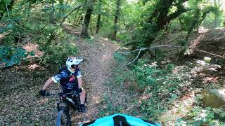
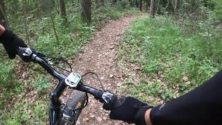
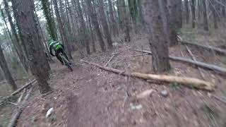
Nice trail born from an old Motorcycle line reshaped for bike use. The name comes from the fact that the start and the end of the trail are close to the railway and this is the trail that bring you to the far est trail area. First part alternate little steep part to flatter one with a good flow. A small rollercoaster bring you to a a fabulous pine forest and "black heart" zone. It's not the longest trail of the area but for sure one of the nicest one

Access Info Restricted Access

from Crni Kal follow the signs for the climbing cliff parking. From the parking take the fireroad also used by the climbers to reach the cliff. Ride it (first part up then down) and when the downhill get flatter at your right you have the trailhead (you will also see an old hunter house on a tree just next to it)

Disclaimer

troubles due to locals

Local Trail Association

Recent Activity on Trail

Past Week
  • 0 rides
  •  
6 Months
  • 2 rides
  • 11 miles avg distance
All
  • 34 rides
  • Last: Dec 29, 2025
c1c2c3c4
January
February
March
April
May
June
July
August
September
October
November
December
update trails status or condition

Oriente Express Trail Reports

Status:
on Jan 3, 2026
Avg: 4.55 (12 votes)
Your vote: 0

view (491)
close
3D
Trail Conditions
  • Unknown
  • Snow Groomed
  • Snow Packed
  • Snow Covered
  • Snow Cover Partial
  • Freeze/thaw Cycle
  • Icy
  • Prevalent Mud
  • Wet
  • Variable
  • Ideal
  • Dry
  • Very Dry
Trail Flow (Ridden Direction)
Trailforks scans users ridelogs to determine the most popular direction each trail is ridden. A good flowing trail network will have most trails flowing in a single direction according to their intension.
The colour categories are based on what percentage of riders are riding a trail in its intended direction.
  • > 96%
  • > 90%
  • > 80%
  • > 70%
  • > 50%
  • < 50%
  • bi-directional trail
  • no data
Trail Last Ridden
Trailforks scans ridelogs to determine the last time a trail was ridden.
  • < 2 days
  • < 1 week
  • < 2 weeks
  • < 1 month
  • < 6 months
  • > 6 months
Trail Ridden Direction
The intended direction a trail should be ridden.
  • Downhill Only
  • Downhill Primary
  • Both Directions
  • Uphill Primary
  • Uphill Only
  • One Direction
Contribute Details
Colors indicate trail is missing specified detail.
  • Description
  • Photos
  • Description & Photos
  • Videos
Trail Popularity ?
Trailforks scans ridelogs to determine which trails are ridden the most in the last 9 months. Trails are compared with nearby trails in the same city region with a possible 25 colour shades. Think of this as a heatmap, more rides = more kinetic energy = warmer colors.
  • most popular
  • popular
  • less popular
  • not popular
ATV/ORV/OHV Filter
Max Vehicle Width
inches
US Cell Coverage
Legend
cell carrier legend

Radar Time
Activity Recordings
Trailforks uses anonymized public activity data. ?
Activity Recordings
Trailforks uses anonymized public activity data. ?
Personal Heatmap
Activity Types
all / none
Options
2
Date range month
Winter Trails
Warning A routing network for winter maps does not exist. Selecting trails using the winter trails layer has been disabled.
Missing Trails
Most Popular
Least Popular
Trails are colored based on popularity. The more popular a trail is, the more red. Less popular trails trend towards green.
Jump Magnitude Heatmap
Heatmap of where riders jump on trails. Zoom in to see individual jumps, click circles to view jump details.
BC Backroad Status

Service Road Atlas is a free to use, community-driven service for viewing and creating reports on the numerous back-country service roads around B.C. and Alberta.

map legend
Slope Aspect
Direction the slope faces
Flat N NE E SE S SW W NW
Trails Deemphasized
Trails are shown in grey.
disable
Only show trails with no bike usage.
Enable
Suggested Layers
Based on selected activity type

    Save the current map location and zoom level as your default home location whenever this page is loaded.

    Save
        Directions to oriente-express trailhead (45.546680, 13.887530)

        Photos

        5 more »
        308 |
        Nov 29, 2017 @ 2:14am
        Nov 29, 2017
        380 |
        Nov 29, 2017 @ 2:00am
        Nov 29, 2017
        348 |
        Nov 29, 2017 @ 1:59am
        Nov 29, 2017
        308 |
        Nov 29, 2017 @ 1:59am
        Nov 29, 2017

        Videos

        5 more »
        Oriente expres 2021
        4:44 | 455 | Sep 13, 2021 , Koper
        Orient Express Trail
        6:51 | 355 | Jul 11, 2021 , Koper
        Oriente Express - Črni Kal - 30 may 2021
        6:16 | 315 | Jun 11, 2021 , Koper
        Oriente Express MTB Trail
        3:44 | 582 | Jan 27, 2019 , Koper

        8 Reviews & Comments


        We hope you've been enjoying Trailforks!

        Create a FREE account to view trail comments and much more.

        • By VarneTF Pro TMTBT & contributors
        • #111376 - 5,586 views

        Frequently Asked Questions About Oriente Express

        Where is Oriente Express located?
        Oriente Express is located in Tinjan, Koper, Slovenia. It is part of the Tinjan trail network. The trailhead is located at coordinates 45.54668, 13.88753.
        How hard is Oriente Express?
        Oriente Express is rated as Blue difficulty. The average grade is 15.1%.
        What is the elevation gain for Oriente Express?
        The trail has 509 ft of elevation descent. The elevation ranges from 401 ft to 911 ft.
        Is Oriente Express a point to point trail?
        Oriente Express is not a point to point trail. The direction is Downhill Primary. The trail type is singletrack.

        Hit the Trail

        Open in App

        Get this trail on your phone instantly.
        open trail in app

        Download Trail

        Save to wishlist, Garmin & download.
        save the trail

        Find Related Routes

        Find routes and users activities that include this trail.
        find routes for this trail

        You must enter a description before submitting.